
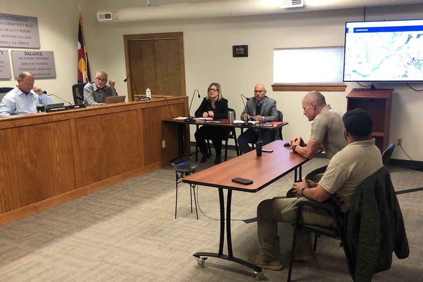
Photo: Archuleta County Sheriff Mike Le Roux outlines a wildfire mitigation proposal at the May 19 meeting of the Archuleta Board of County Commissioners. The map in the background shows the Martinez Canyon area.
Many individual property owners and neighborhood groups, here in Archuleta County, have been considering the wisdom of mitigating the flammable vegetation in their immediate vicinity. Removing trees and brush close to structures, for example.
On a larger scale, we have governments in Colorado making plans and laws for dealing with wildfire risk in entire communities.
We heard about some of these bigger plans at local government meetings over the past several days.
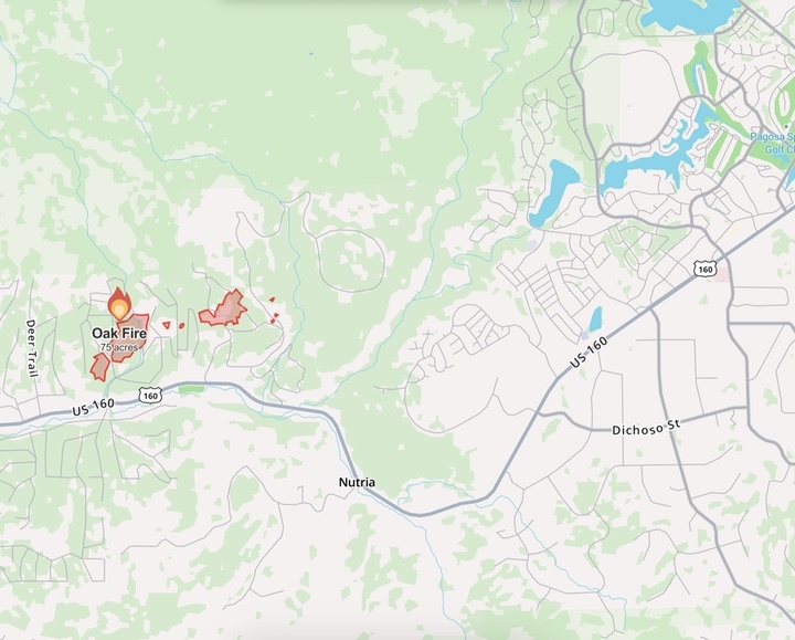
For example, we heard a presentation by County Sheriff Mike Le Roux at Tuesday’s Board of County Commissioners’ meeting. Sheriff Le Roux began by reminding the commissioners about the 2025 Oak Fire that burned about 75 acres in the Aspen Springs area.
Not that the commissioners needed reminding.
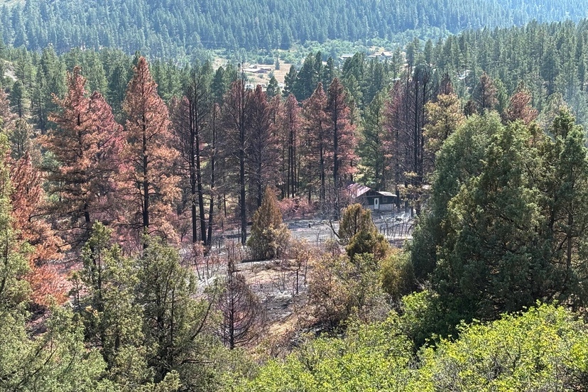
Daily Post writer DC Duncan wrote an essay about that event back in August, shortly after the fire was contained.
From that essay, written from the perspective of an Aspen Springs neighbor who was, fortunately, not directly affected:
I have been fire mitigating our property for years now, and still need to mitigate down the hill. (Fire loves hills!) I even forbade my brother from smoking in our shop. But there’s only so much one can do; it takes the whole community, hand in hand, to make a difference. Everyone needs to exercise great caution, clean up their property and vote for people who respect our precious environment. (You won’t know you need FEMA, until it’s too late.)
I’m thankful that we survived the Oak Fire, and we are thinking of our neighbors who lost so much. It was quite a scare.
Lesson learned: Sometimes in life, survival depends upon something so simple as which way the wind blows.
Historically, much of the wildfire mitigation that’s been done in Archuleta County — forest thinning, prescribed burns, and so on — has been handled by the U.S. Forest Service, which make a lot of sense, given that about 50% of the county is federally owned — National Forest, National Monument, or BLM (U.S. Bureau of Land Management). Another portion has been mitigated by private property owners like Mr. Duncan.
But as Mr. Duncan noted, survival can depend on something as simple as which way the wind blows.
Here in southwest Colorado, the wind typically comes from the west, as it did last August 10, blowing flames and embers towards one of the most populated areas in the county: Pagosa Lakes.
Given stronger winds on August 10 and 11, the fire could have easily burned its way through Elk Park and spread to the densely-populated Lakes area.
This event formed the background for the proposal made by Sheriff Le Roux to the BOCC yesterday, concerning a possible grant application to treat the flammable fuels in Martinez Canyon.
“We’ve been putting some figures and facts together, and by June 1, we have to submit the grant application — not the entire application but a portion — to the Division of Homeland Security Emergency Management. They will do a review and then June 15 will be the final application deadline…
“So we have a little bit of time…”
He brought up a map of the area west of town where the Oak Fire had threatened to spread — but didn’t, thanks in part to an aggressive suppression effort.
“The crew did a fabulous job… and one of the primary objectives was to keep it out of Martinez Canyon, which you can see here…” (pointing to the map) “this deep, dark vein of untreated fuel, that brings us all the way up into the Lakes area, here…”
Here’s a Google map of the area threatened by the Oak Fire. Martinez Canyon does indeed show up as a deep, dark vein in the center of the map, running in a generally northeasterly direction from Highway 160 and forming a western boundary for the Pagosa Lakes neighborhoods.
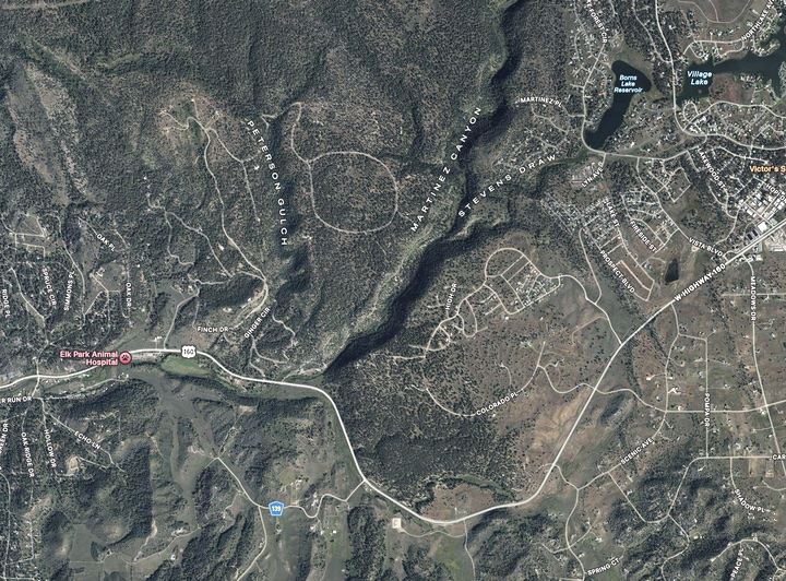
Most of us might describe the canyon as “forested”. But to folks involved in emergency management, it’s a rich source of “untreated fuels”.
What might it cost the taxpayers to “treat” the untreated fuels?
Sheriff Le Roux:
“You can see that the canyon splits about 2/3 of the way up, [Stevens Draw] run up to [Lake Forest] which is critical infrastructure for us. The rest of the canyon runs up into the Forest Service and runs across the back there. Over the years, in Turkey Springs, the Forest Service has done a great job there of mastication and mitigation, on the west side of the canyon. There’s talk of them potentially doing some more thinning on the east side of the canyon, which backs up against all these residences here…
“If I zoom out, you can see what’s potentially affected by a fire in that canyon, coming all the way up. The canyon’s about 2.8 miles long and runs in the same direction as the prevailing wind… and it’s nasty in there…”
Presumably, the Sheriff and his team are concerned about this particular canyon, not just because it contains “untreated fuels” but also because of the difficulties controlling a fire on steep slopes and at the bottom of a burning canyon.
During the Oak Fire, the residents living near Martinez Canyon were put on pre-evacuation notice.
Sheriff Le Roux:
“We did have an assessment done, and there’s about $720 million worth of property in that area. And that’s only about 1/3 of the PLPOA area…”
He noted that this assessment of property values did not include the commercial area around City Market… which also could potentially be threatened by a fire spreading from Martinez Canyon…