
Some people have been working hard, these past few decades, to put Pagosa Springs on the map, so to speak.
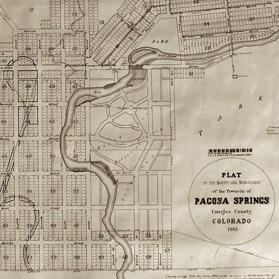
Not “on the paper maps”. Pagosa has been on paper maps since at least 1883.
And we’ve been on the online Google maps since at least 2005.
But some people have been working to put us “on the map” in the sense of “somewhere in the forefront of people’s consciousness”. A place that comes easily to mind, without the need to think too hard.
For this editorial series, I looked up definitions for the word “map” , because I was planning to write about a different kind of map. Not a “paper map” or a “Google map”, but a conceptual map.
Here are just a few of the ways we Americans use the word “map”:
noun. A representation, usually on a plane surface, of a region of the earth or heavens.
noun. In mathematics, the correspondence of elements in one set to elements in the same set or another set.
noun. In biology, a genetic map.
transitive verb. To explore or make a survey of (a region) for the purpose of making a map.
transitive verb. To plan or delineate, especially in detail; to arrange.
idiom. “all over the map” Showing great variety; varied or diverse.
idiom. “put something on the map” To make well-known, prominent, or famous.
noun. Figuratively, a distinct and precise representation of something.
My goal this week is to address the last definition shown in the list above — to sketch out a “distinct and precise representation” of my town.
We’re tempted, often, to think of Pagosa Springs in terms of “a collection of “places where things happen”. Streets where people drive. Stores where people shop. Jails where people are locked up. Cemeteries where people are buried. Places, located at certain distances from one another.
A physical map is also typically related to a specific date in history, because we humans are typically busy, working to alter the landscape.
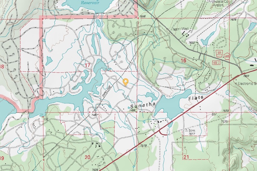
The topographic map image above appears to date from around 1975. I noted a few details… things that have changed since the 1970s. Hot Springs Boulevard didn’t exist. There was a gravel pit in the middle of what is now the Town-owned wetlands. The largest building complex was the Sawmill, at the intersection of Highways 160 and 84. The High School was centrally located in downtown, and didn’t include an enormous parking lot, or a football stadium.
But otherwise, downtown Pagosa, then, looked a lot like it does in 2021, in terms of streets and buildings, to judge by this topo map.
Uptown is a different story. The same online topo map shows the Pagosa Lakes subdivisions laid out in a typical 1970s subdivision pattern, but as yet, very few homes. No commercial development along Highway 160. No hospital. No Walmart. No City Market Shopping Center. Just acres and acres of (rather poorly constructed?) subdivision roads, waiting for a population influx.
If Pagosa Lakes had stayed this way, what a different Google map we would be viewing in 2021.
But as I mentioned, this editorial series aims to draw a different type of map. Thanks to modern satellite imagery, we can find informative, relatively accurate physical maps — on Google, for example, and on the Archuleta County website.
Something that’s harder to find: “Figuratively, a distinct and precise representation of Pagosa Springs.” A map of how Pagosa Springs operates. A map of relationships. A map of needs, met and unmet.
As I begin writing this, during the beginning of Spring Break 2021, I’m not sure exactly what this conceptual map will look like, or whether it will be “precise”. I’ve never tried to make a conceptual map, before.
But it will be some kind of a map, reflecting as best I can, a certain rural town in Colorado, on a certain date in history.
One piece of the map will concern the physical health of Pagosa Springs.
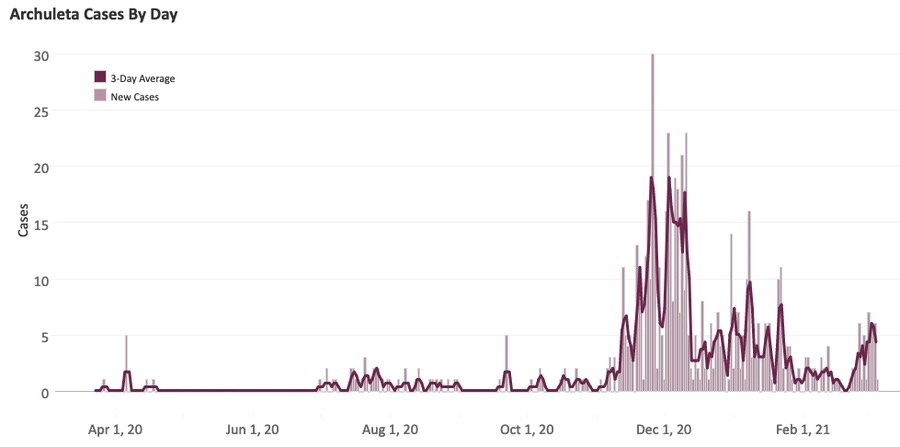
Our local public health agency, San Juan Basin Public Health, has been tracking, fairly religiously, one particular aspect of the community’s health — a certain viral infection known as COVID-19. The virus was hard to find in Archuleta County, between April and October, 2020, but became much more obvious between November and February. Since the end of February, the community has been seeing something of a spike, similar to what we saw during early January, when the town was still in Level Red on Colorado’s COVID Dial.
Despite these variations, only one Archuleta County death has been attributed to COVID-19 by San Juan Basin Public Health, since the pandemic was officially announced over a year ago.
Although COVID data is fairly easy to find in March 2021, several things related to public health have not been tracked. I cannot locate any current Archuleta County data related to mental health… or suicides… or drug addiction… or alcoholism… or malnutrition… or hunger. I haven’t been able to find any current data related to chronic illnesses… or any contagious diseases other than COVID. Maybe we’re too busy tracking COVID?
How many people, in March 2021, are reluctant to seek health care services in Archuleta County — for physical or mental health issues — because they can’t afford the medical bills? We don’t really know.
As far as I can tell, we have some huge holes in the “public health” portion of our map.
How about “shelter”?
Here’s a detail that could appear in a different and much larger map — an conceptual map of the United States. It purports to show the availability of homes for sale in the US. It was created by The New York Times, from a February 26, 2021 article titled, “Where Have All the Houses Gone?”
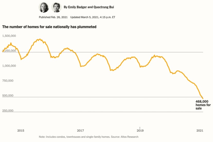
Can we create a map element like this for Pagosa Springs? I wonder…