
Cartography has gone through a number of phases during human history. Back in 1190 AD, a European theologian known as ‘Honorius of Autun’ created a map of the Earth based on the concept that the world was an enormous flat disc, occupied by three continents surrounded by a circular ocean. Near the center of the disc one finds, appropriately enough, the Mediterranean Sea — “Mediterranean” meaning, after all, “the middle of the earth” — and one also finds the perceived centers of human spirituality: Rome, Athens, Jerusalem.
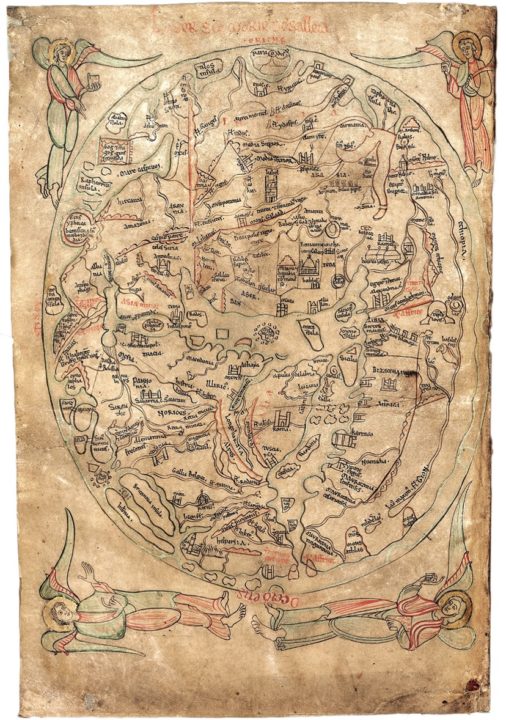
China and Japan are at the very top of the map. Africa is off to the lower right. The two little blobs at the bottom left are presumably the wild, unexplored islands of Great Britain and Ireland.
Fast forward to the 1500s, when European cartographers were trying to wrap their heads around the concept of a spherical — rather than flat — Earth. They understood that something of importance lay ‘out there’… off to the west, across the Atlantic Ocean… but for the time being, that part of the map was mostly left blank.

Living in the 21st century, during a time when orbiting satellites are constantly creating detailed photographic images of our planet, it’s difficult to imagine the intellectual processes a 16th century cartographer must have used to create an “Orbis Typus Universalis” like the one shown above.
Physical maps… we’ve got that trick down pat. A few keystrokes on a computer keyboard can bring up a visual representation that cartographers in the 1500s could only dream about.
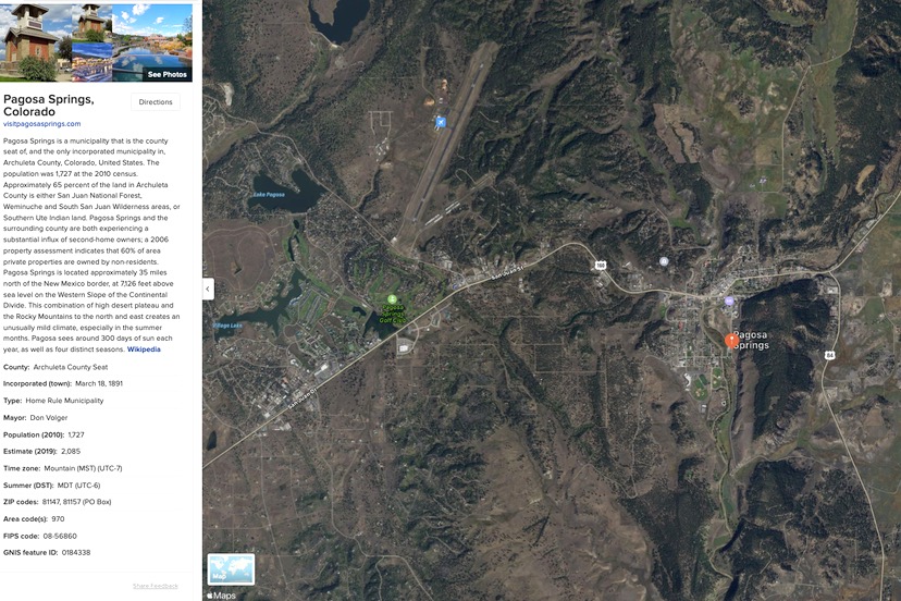
The map can even include “local color” by way of a photograph of the downtown Bell Tower and the downtown Springs Resort, with an option to view more photos with the click of your mouse (or poke of your finger).
We find some map-related information as well, taken from Wikipedia:
Pagosa Springs, Colorado
Pagosa Springs is a municipality that is the county seat of, and the only incorporated municipality in, Archuleta County, Colorado, United States. The population was 1,727 at the 2010 census… Pagosa Springs and the surrounding county are both experiencing a substantial influx of second-home owners; a 2006 property assessment indicates that 60% of area private properties are owned by non-residents…
County: Archuleta County Seat
Incorporated (town): March 18, 1891
Type: Home Rule Municipality
Mayor: Don Volger
Population (2010): 1,727
Estimate (2019): 2,085
Time zone: Mountain (MST) (UTC-7)
ZIP codes: 81147, 81157 (PO Box)
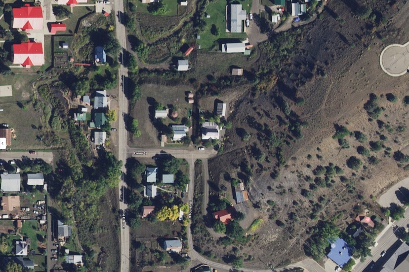
We can zoom in on a particular neighborhood. Here’s my neighborhood. The Daily Post home office is at the very center of this map. Based on the automobiles shown parked next to the house, I’m guessing the image is about one year old.
 We live in a world where physical maps are incredibly accurate and detailed. “Blank spaces” no longer exist — practically speaking.
But other types of “mapping” projects can reveal some blank spaces in our knowledge of the world.
Our (ambitious?) Daily Post project this week: to create a ‘conceptual map’ of Pagosa Springs in March 2021, based upon a less familiar definition of the word “map”.
noun. Figuratively, a distinct and precise representation of something.
Yesterday, we discussed some blank spaces in our conceptual map of Pagosa. During a moment in time when so much focus is on the prevention of illness, we actually have very little information about many types of physical disease, mental illness, and nutritional distress. We know there is something important ‘out there’… but we don’t know what it is.
We also began a discussion, yesterday, about another part of Pagosa’s conceptual map, when we shared this graph created by The New York Times, from a February 26, 2021 article titled, “Where Have All the Houses Gone?”
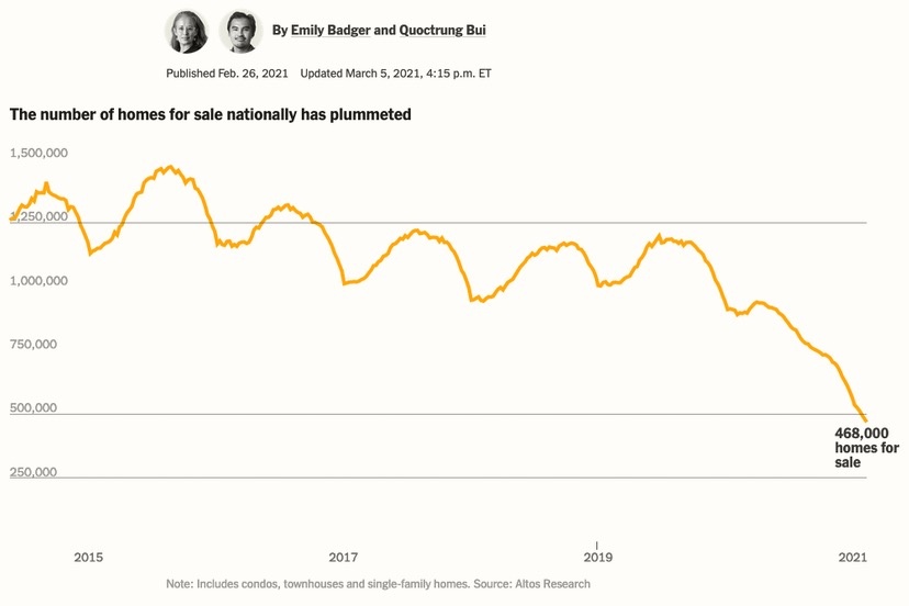
I interpret this map element to be an illustration of a national (and perhaps international) trend during the COVID pandemic — a year of economic and physical stress. The NYT reporters used real estate data from Altos Research to sketch out a temporal map of the US market. Apparently, during the summer of 2016, US real estate agents were listing close to 1.5 million homes available for purchase.
The number of available homes had dropped below 1.2 million, by the summer of 2019.
According to Altos Research, the US real estate market currently has less than 500,000 homes on the market — about one-third the number in the summer of 2016.
One of my projects this week will be to create a “map” of the housing market in Pagosa Springs, with an eye to inventory changes over the past few years. We’ve been told, by the New York Times reporters, that the inventory of homes for sale has declined sharply in some major US cities.
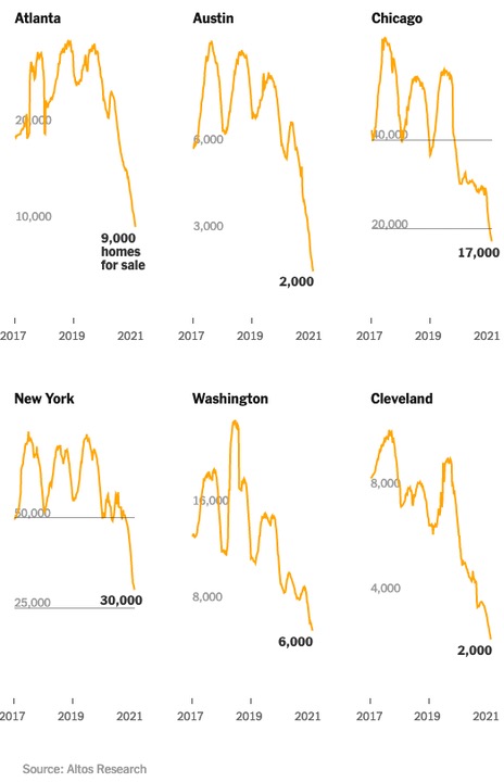
The inventories in Atlanta, Chicago and Washington DC appear to fallen to less than half the number of available homes, since 2017. In Austin and Cleveland, it appears that the inventory is less than one-quarter what it was in the summer of 2017.
I’ve heard rumors that a similar dynamic is taking place in Pagosa Springs, accompanied by skyrocketing home prices.
Can we put those numbers into a ‘map’?