
As mentioned previously in this article series, Forest Health Timber Products LLC — which I believe is Pagosa’s largest forest mitigation company — has been treating forested areas in Archuleta County since about 2012. These treatments typically accomplish one or more important goals.
Removing some of the trees and masticating the underbrush in ‘overgrown’ forests can theoretically reduce the chances of a catastrophic wildfire. Historically, wildfires occurred in southwestern Colorado forests every 12-20 years, as part of a natural cycle that contributed to overall forest health. But when American governments and corporations began aggressively snuffing out forest fires and grassland fires 100 years ago, our forests gradually became unhealthy… in the eyes of contemporary forestry scientists.
The removal of biomass from the forest — and hopefully, productive use of the removed biomass — can theoretically create forests less likely to be destroyed by fire, and less likely to spread into urban and suburban areas.
So Goal Number One: Healthier, safer forests that can burn with less collateral damage .
Goal Number Two: Protection and enhancement of the community’s water supplies. Following a catastrophic fire, the protective vegetation is gone and no longer holds the soil in place — and rainstorms then cause the soil to wash into rivers and creeks, polluting the water, killing fish and marine animals and vegetation, and clogging the equipment in water treatment plants. Following the 416 Fire in Durango, for example, some sources estimated an 80% reduction in fish in the Animas River due to subsequent soil erosion.
Goal Number Three: Protection of the community’s infrastructure such as electric power lines… water pipelines and diversion structures… and roadways.
Goal Number Four: Subsidizing the timber industry. Southwestern Colorado has become ever more dependent on the tourism industry in ways that some see as detrimental, and forest mitigation and biomass use can help diversify local economies.
Goal Number Five: Subsidizing Colorado’s recreation industry. Catastrophically destroyed forests are — simply stated — less likely to attract the recreationalists who contribute an estimated $18 billion annually to the state’s economy. A healthy ‘treated’ forest, meanwhile, is more likely to attract birds and other wildlife, and birds and other wildlife, in turn, attract recreationalists.
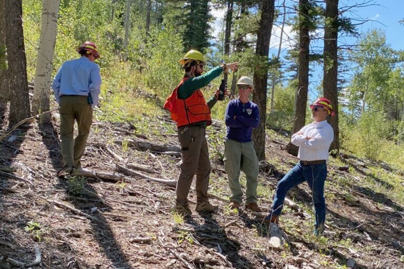
When I sat down last week with JR Ford — founder of Forest Health Timber Products LLC — he described a treatment project along the Upper Blanco Basin Road that will reduce the number of trees and remove other vegetation, extending about 300 feet into the forest on either side of the road. These treated “firebreaks” can help firefighters contain even catastrophic wildfires, assuming the winds cooperate. (As Mr. Ford notes, when the winds fail to cooperate with suppression efforts, wildfires simply do whatever they want to do.)
The treatment project involves about 300 acres and is aimed partly at protecting the the federal San Juan–Chama Project, a series of tunnels and diversions that take water from the Blanco and Navajo Rivers in Archuleta County, to supplement water resources for irrigation and municipal water for communities along the Rio Grande, including Albuquerque and Santa Fe.
So another 300 acres will be treated… out of the 873,000 acres in Archuleta County.
Are we even putting a dent in the problem? Perhaps all we can hope for are smaller, strategically-located thinning projects to minimize the very worst effects.
But where should those projects take place? And who will pay for them?
On May 14, JR Ford’s son Matt Ford — one of the founding members of the San Juan Headwaters Forest Health Partnership — gave a presentation to the Pagosa Area Water and Sanitation District (PAWSD) board of directors, concerning a “Wildfire Ready Action Plan”… more affectionately known as a “WRAP”. This plan would potentially be grant-funded, and is supported by two volunteer organizations: San Juan Headwaters Forest Health Partnership and the Upper San Juan Watershed Enhancement Partnership. The plan would align with a template developed by the Colorado Water Conservation Board.
Disclosure: I currently serve as a volunteer on the PAWSD Board of Directors, but this editorial reflects only my own opinions, and not necessarily the opinions of the PAWSD Board and staff.
We all know that the squeaky wheel gets the oil. Which, in this case, would be the grant funding. And the local-taxpayer-funded match.
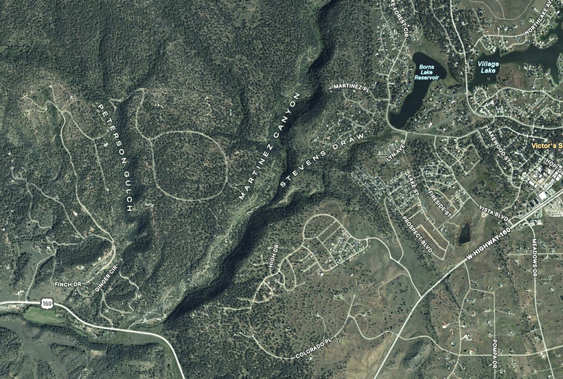
Back in Part One of this editorial series, we heard from Archuleta County Sheriff Mike Le Roux about a $750,000 grant that might pay for the treatment of about 300 acres along the east and west rims of Martinez Canyon — the ‘overgrown’ canyon that runs along the western edge of the Pagosa Lakes subdivisions. This federal grant — if awarded — would require significant matching funds from Archuleta County or other agencies.
The grant that Matt Ford described at the PAWSD board meeting would amount to perhaps $400,000, and would pay for — not actual forest treatments — but rather, the development of a plan covering much of the Upper San Juan River drainage.
It would also require matching funds. Perhaps $100,000? From whom?
From the May 14 presentation by Matt Ford, and Monica Nigon, coordinator for the San Juan Headwaters Forest Health Partnership:
Wildfire Ready Action Plan (WRAP)
Fund design and construction guidance including project types that can be implemented before and after wildfires.
Provide guidance to help predict where and what post-fire impacts will be felt in local communities.
Lead to actionable Wildfire Ready Watersheds projects.
Here’s a map from that presentation. The darker ‘orange’ areas are not necessarily more prone to wildfire than the ‘green’ areas, but the impacts in those areas would likely be more devastating.
The black line at the right is the Continental Divide, and the line at the bottom is the New Mexico border.
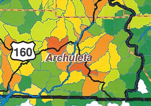
Obviously, we cannot predict where — among the 873,000 mostly-flammable acres of Archuleta County — the next wildfire will occur. But the impacts on homes, infrastructure, water, timber resources, and recreation (and tourism) will be different, depending on ‘where’. For $400,000, can we come up with a plan for future projects — before and after wildfires — so that we prepare in a way that crucial needs are most likely to be addressed?
For example. Sheriff Le Roux has proposed a $750,000 treatment project for the rim of Martinez Canyon.
Is that the best place to spend $750,000 taxpayer dollars? We do not currently have a well-documented plan that supports such an assumption. The Sheriff might be basically ‘shooting from the hip’ by picking this particular location as a place to invest money and effort.
We know, for instance, that the 2025 Oak Fire threatened to spread into Martinez Canyon… but did not. The chances that another fire will threaten Martinez Canyon, in the near future, may be rather small?
If we can treat only about 300 acres a year, perhaps what we need is a well-documented plan that tells us ‘where’ the impacts of future taxpayer investments — before and after wildfires— would be most helpful. Rather than, say, ‘shooting from the hip’.
On the other hand, maybe we’re screwed, no matter what we do.