
Colorado voters have a crucial role to play in this: we can no longer stand idly by when it comes to passing sustainable funding for Colorado’s Water Plan. We need to seriously embrace the challenge to pass meaningful water funding in 2020…
— from an op-ed by Bart Miller, Healthy Rivers Program Director at Western Resource Advocates, published on the Colorado Sun website on June 30, 2019

Speculation. It suits the American persona. We make heroes of people who are willing to venture big risks, take a leap in the dark, gamble with their fortunes. We’re not so pleased, however, if they are gambling with our public funds, or with our public resources.
Disclosure: I currently serve on the San Juan Water Conservancy District board, but this essay does not necessarily reflect the opinions of the SJWCD board as a whole or of any other SJWCD board members.
Water industry advocates like Healthy Rivers Program Director Bart Miller were full of hope a year ago — following two decades of inconsistent precipitation across the American West — that Colorado voters were ready to dig into their pockets and fund the still-unfunded Colorado Water Plan of 2015. He wrote about that hope in a Colorado Sun op-ed last year, and also mentioned the size of his wish. $100 million annually.
We shared some numbers around that same time, back in July 2019, in an editorial titled, “Believe It or Not, Colorado Will Soon Become a Waterless Desert…”
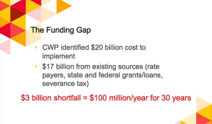
The Colorado Water Plan, developed during the Hickenlooper administration and approved in 2015, has been described as “a new path to secure a water future that protects our state’s rivers; secures clean, safe, reliable drinking water for our communities; and preserves our agricultural heritage.” In 2013, the cost of CWP implementation was estimated by plan advocates at $20 billion.
Four years later, in 2017, Becky Mitchell, the newly appointed director of the state-funded Colorado Water Conservation Board, updated the estimate. Mitchell put the anticipated price tag at $40 billion, and “maybe more”. Some $18 billion was likely to be paid by existing sources such as municipalities, water utilities, and ditch companies that deliver water to farms and ranches, she said. She described the remaining $22 billion as an “unmet funding need.”
“Cost projections have always been just estimates, and part of that is because not all the information is in,” Mitchell said. “What we’re already seeing, as folks are solidifying our numbers, is that it’s going to be more than earlier predictions.”
Two years later, in May 2019, a well-funded campaign organization called ‘For the Love of Colorado Coalition’ distributed a report quoting the estimated price of CWP implementation as $20 billion.
$20 billion… or $40 billion. Is there really any big difference? But for folks like Mr. Miller, who are hoping for just $100 million per year… maybe even $20 billion is… out of reach.
Or maybe not? Maybe that $100 million number is merely to cover a slight shortfall? That idea was suggested to us in the ‘For the Love of Colorado Coalition’ report:
This money, whatever the amount, is aimed at moving and storing water, a resource that some experts insist is in short supply.
The real water problem in the American West, however, is not a lack of rain or snow. The American West has consistently experienced inconsistent precipitation, for extended periods of time, such as during the late 1800s and during the 1930s, for example. The real problem was accurately and succinctly described by Henry “Scoop” Jackson, US Senator from Washington State:
“The Colorado River doesn’t have a water scarcity problem; it has a planning and zoning problem.”
Although the Colorado provides the water for America’s two largest reservoirs — Lake Mead and Lake Powell — the river’s average flow does not even qualify it as one of the 20 largest rivers in the US. Yet water industry experts have long believed that, with the able assistance of Mead and Powell, the Colorado was capable of serving a happy and growing population in the American Southwest of perhaps 40 million people — while also helping to serve, through transmountain diversions, the growing urban centers on the other side of the Continental Divide: Denver, Colorado Springs, Boulder and so on.
It’s become gradually more apparent that the water industry experts might be dead wrong about that. (But do experts ever admit that they are wrong?) As I peruse various articles about water in the Southwest, written by many of these same experts, I am told that the real problem is not planning and zoning after all. It’s ‘climate change.’ The American West is, quite simply, drying up. Or so they say.
If you happen to search on Google for graphs showing the ‘historic flows’ of the Colorado River, you will come across numerous charts that illustrate the river flows starting in about 1905 or maybe 1910. I assume the point is to show “the most recent century’s worth of data”… and perhaps to show the effects of climate change with a slowly-descending green line?
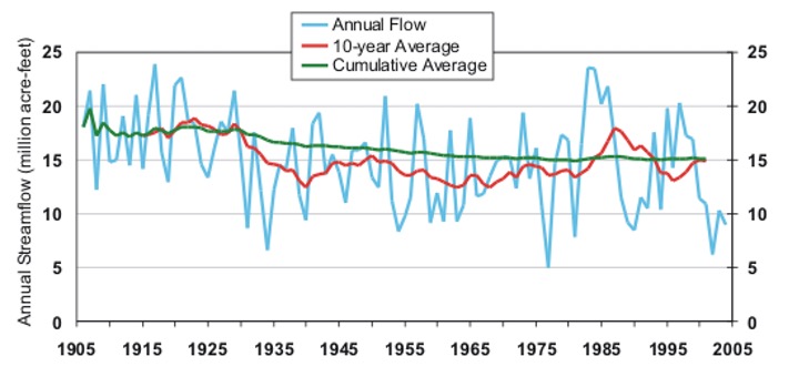
The blue line on this graph indicates wildly inconsistent amounts of precipitation in teh American West since 1905. The Colorado River hit some dramatic high points several times between 1905 and 1930, and between 1983 and 1987, and then again in the late 1990s. Dramatic low points are seen around 1934 and 1954, and then again around 1977 and 2002.
But if we search a bit harder, we also have access to scientific estimates dating back to the 8th century. These charts are more difficult to locate… and not too popular with water industry experts, perhaps, because they do not show a slowly declining green line.
The chart below was constructed by scientists who analyzed “tree rings” going back to the year 762. Their theory is that trees always grow faster when we have above-average precipitation, and grow almost not at all during a drought. In the chart, they drew a dotted line at 15 million acre feet, which was the amount of water assumed to be the “average flows”… back in 1922 when the Colorado River Compact was signed by the seven states sharing water from the river. (Some scientists were arguing, even in 1922, that 15 million acre feet was an unreasonable average, but they were ignored.)
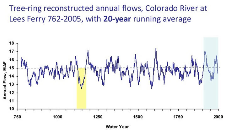
The 1922 agreement was signed in the midst of one of the wettest periods in recent history for the American West. As you see in the chart, the analyzed flow of the Colorado is generally less than 15 million acre feet – and very often precipitously less. Between the years 800 AD and 1200 AD — that’s a 400 year period — the Colorado River only rarely flowed at 15 million acre feet.
But to this day, the political decisions in Congress and among the seven Colorado Basin states have been consistently based on 15 million acre feet as a reasonable average. And for the final third of the 19th century, the flow remain far below 15 million acre feet.
But with all the talk about water, (and about “sustainable funding for the Colorado Water Plan”) much of the well-publicized distress about the falling lake levels at Powell and Mead is actually related to a different issue: hydroelectricity. The Hoover Dam produced more than 10 TWh (trillion watt hours) of electricity in 1984. In 2015, due to lower water levels, the production was only 3.6 TWh. If the lake level drops below 1,050 feet elevation, the dam will no longer be able to generate power.
The Glen Canyon Dam, on Lake Powell, generated 8.7 TWh in 1984. In 2005, the dam was able to generate only 3.3 TWh. If the reservoir elevation drops below 3,490 feet, there won’t be enough water flowing through Glen Canyon Dam’s turbines to generate electricity.

Even though both reservoirs are currently at near record-low levels, both must continue to release water, for several reasons. Obviously, both release water when they’re producing electricity. Lake Mead must release water to fill the numerous aqueducts and downstream reservoirs that serve Arizona and California, as well as for environmental reasons — to preserve plant and animal life in and along the river. Lake Powell, meanwhile, is legally required to release water to keep Lake Mead above 1,050 feet elevation, and to maintain some kind of water level in the Grand Canyon, for environmental and recreational needs.
In the face of all these problems, the population of the American West keeps growing. And our governments keep promoting that growth.
A good time to invest in senior water rights?