
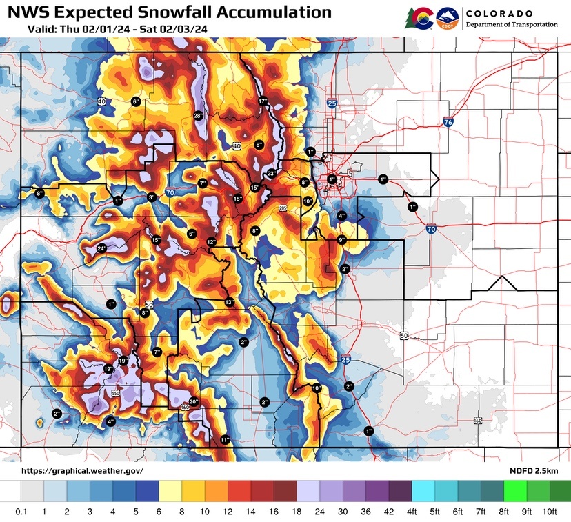
Another round of snow is making its way across the state this weekend, with the majority of impacts occurring in southwest Colorado and the high country. Rain/snow showers began spreading into the Four Corners on Thursday night, expanding northward through Friday afternoon.
The heaviest snow during this period should largely favor the Southern mountains. Snow is predicted to make its way to Colorado’s northern and central mountains on Friday evening, lasting through Saturday night.
This snowfall is expected to overlap with ski traffic along the I-70 Mountain Corridor on Friday night. Motorists should prepare for travel disruptions anticipated for Saturday throughout the day. Current snow totals of one to two feet or more are likely for the majority of Colorado’s mountain passes.
“Travel along Colorado’s mountain roads, specifically the I-70 Mountain Corridor, will be challenging this weekend, not only because of the weather that is predicted, but also due to heavy traffic as folks make their way up to take advantage of fresh snow,” said John Lorme, the Colorado Department of Transportation’s director of maintenance and operations. “It will be slow moving along the Corridor this weekend, so remember to be patient and make sure you are not the cause of a road closure. Ensure your vehicle is fully equipped to handle winter weather before heading out, and pack the essentials in your vehicle such as blankets, extra coats, water, food and entertainment in the likely event of a closure. The best way to arrive at your destination safely is to drive for the conditions and maintain a safe space between you and the car ahead of you.”
A significant amount of snow is expected to hit southwest Colorado’s high country and US 40 Berthoud Pass over the weekend, popular backcountry recreation destinations, which may pose avalanche risks throughout the weekend. With heavy snow anticipated, backcountry recreationalists are urged to avoid venturing into areas alongside roadways not only for their safety, but also for the safety of motorists along Colorado’s highways, to prevent people recreating from triggering snow slides onto the roadway. Motorists should be prepared for potential safety closures as CDOT and Colorado Avalanche Information Center crews conduct avalanche mitigation operations. Backcountry users should be aware of avalanche conditions before heading out by visiting Colorado.gov/avalanche for current snow condition forecasts.
“Backcountry avalanche conditions are going to be changing throughout the weekend as the storm moves through the state,” said Ethan Greene, director of the Colorado Avalanche Information Center. “We expect high avalanche danger in most mountain areas on Saturday and dangerous conditions lasting into Monday.”
If you encounter an avalanche while in your vehicle, there are several things you can do to help keep you safe:
- Stay in your vehicle and keep the windows up.
- Turn off your vehicle to prevent carbon monoxide from filling the car.
- Call for help on a cell phone.
- Plan ahead during the winter season and keep additional food, water, warm clothes and blankets in your vehicle.
East of the Continental Divide, the storm will arrive later and is expected to be shorter in duration. Heavy rain and snow is expected Friday evening into Saturday night over portions of east Colorado. The Foothills and Palmer Divide may experience a wet, slushy snow mix Friday evening into Saturday night. Urban areas along I-25 may receive a mix of rain and snow Saturday to Sunday morning. While the bulk of the storm will wind down on Sunday morning, there may still be a few rain/snow showers that will linger over the eastern plains.
While backcountry recreation is not recommended near roadways or in avalanche terrain this weekend, CDOT advises anyone recreating elsewhere to take care when parking. Skiers, snowshoers, and snowmobilers should park only in clearly marked and designated parking areas. Look for caution signs at avalanche areas that indicate no stopping or standing at that location. These areas are prone to snow slides and vehicles or trailers should never be parked at these potential avalanche sites. The slide areas are also often at locations where avalanche mitigation operations may be planned. Never park Also be aware that vehicles parked on highway shoulders can prevent CDOT maintainers from safely clearing the roads of snow and ice, presenting safety hazards for plow equipment, other motorists and commercial traffic.
Before heading out this weekend, motorists should take advantage of CDOT’s COtrip.org or the COtrip Planner app to get real-time information regarding road closures and conditions, take a look at its live cameras or see if the Chain or Traction Laws are in effect. Please visit COtrip.org or download the COtrip Planner app for updates, or sign up to subscribe to travel alerts delivered straight to your phone