
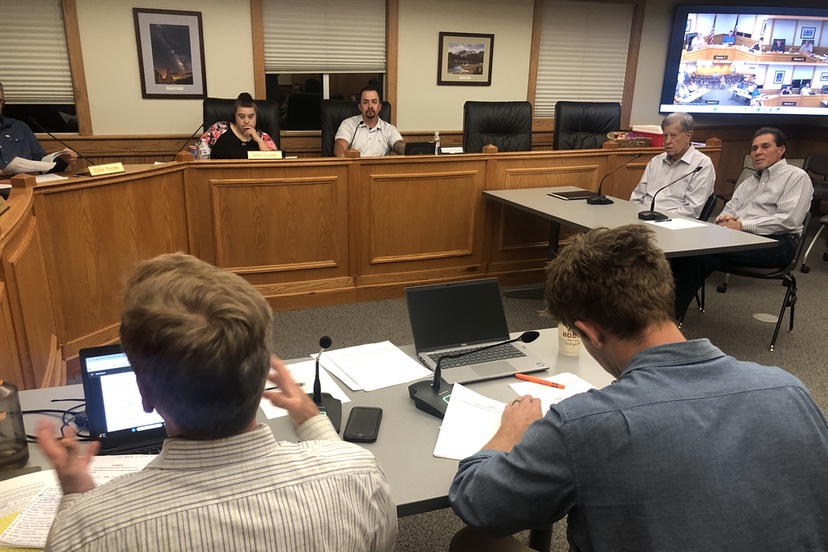
The Town staff had to bring additional chairs into the Planning Commission meeting at Town Hall, last night. About 50 local residents had shown up to hear what the five Planning Commissioners — Chris Pitcher, Julie Gurule, Mont McCallister, Brian Reid, and Mike Torres — would do with a “Sketch Plan” for developing 70 vacant acres adjacent to Great West Avenue and the Alpha/Rock Ridge subdivision.
Based on the testimony offered by audience members during public comment, it sounded like nearly all the attendees lived near the proposed new subdivision.
The first order of business was the approval of a plan to remodel some of the buildings at the existing Healing Waters Resort. When I had reviewed the information packet on Monday, I had the impression that the entire 2-acre resort was due to be re-developed, but the Planning Commission discussion made it clear that only about half of the resort would be affected by this first phase of the plan. The bathhouses and swimming pool would remain the same for the time being, according to the architects from Reynolds Ash + Associates. The Planning Commission approved the plan without too much discussion.
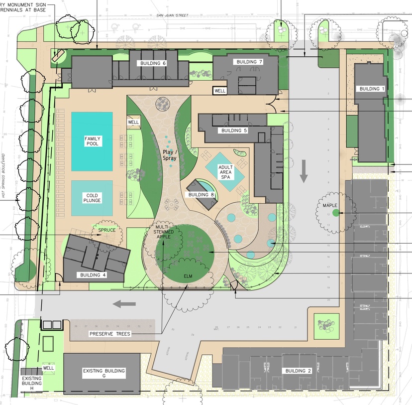
We then arrived at the two highly contentious items that the audience had shown up to protest.
1. Ponderosa Major Subdivision, Sketch Plan Review
2. Ponderosa Mountain Planned Development Agreement
As mentioned yesterday in Part One, the proposal to convert 70 acres of wetlands and Ponderosa pine forest into a residential and lodging subdivision would involve a massive change to the current zoning for that large, vacant parcel, converting it from “Rural Transitional” — allowing about one dwelling unit per acre — into partly “Mixed Use Commercial” and mostly “R-22” which would allow up to 22 dwelling units per acre.
Here’s the vicinity map of the proposed major subdivision.
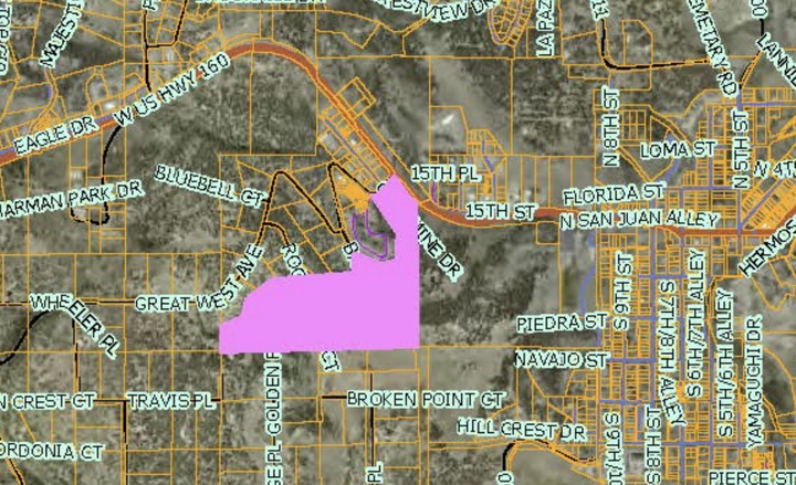
Instead of being a “transitional” development that respected and reflected the generally rural, semi-agricultural properties nearby, the proposal presented to the Planning Commission would allow for the very highest density allowed in the Town of Pagosa Springs.
When I say that the audience had shown up to protest the two proposed Planning Commission approvals, I mean that maybe 48 people had come to show their opposition to the proposed development as presented…
…and two people — the real estate agent representing the seller, and one local landscape architect — had come to speak in favor of the development proposal.
The discussion between the two out-of-town developers of the proposed Ponderosa Mountain subdivision… the Town commissioners… the two members of the Town Planning staff — Planning Manager Owen O’Dell and Development Director James Dickhoff… and the audience… took four hours.
It appeared to me, about halfway through the four-hour hearing, that the Planning Commission was leaning towards ‘tabling’ the two items, to allow the developers to come back with a better plan — one that more fully respected the surrounding property uses.
But in the end, the commissioners approved both proposals, with modifications.
By that point, nearly all of the audience had departed. Presumably, they could see the writing on the wall.
Nevertheless, a lot of interesting ideas were brought up during a four-hour conversation, as you well can imagine.
As we see in the Town Zoning Map detail shown below, the property is part of a large area zoned “Rural Transitional”, surrounded by areas that are outside the town limits — shown in white — and areas within the town limits, zoned for various uses such as “Commercial”, “Open Space” and “Low-Density Residential”.
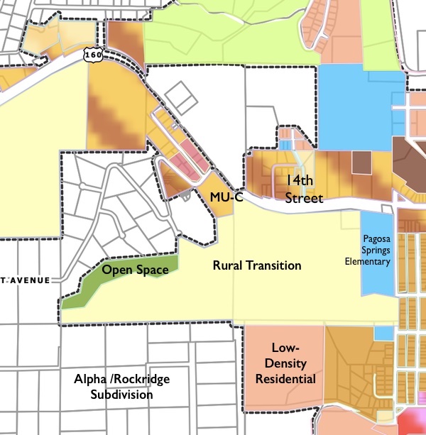
You might note, in the map above, the location of 14th Street. To be discussed in a moment.
We have a curious situation, here in 21st century America. We believe, on the one hand, in private property rights — the right to own, and use, property for private purposes as determined by the owner.
On the other hand, we believe in the power of local government to limit the uses of our private property, when a proposed use might negatively affect neighboring property owners.
We embrace both of these conflicting ideas, and so find ourselves often in conflict about land uses.
The negative effects of the proposed Ponderosa Mountain subdivision cited most often last night:
1. The residential density proposed — 22 units per acre — would allow (theoretically) up to 1,500 dwelling units on the 70 acres. That would be nearly twice as many dwellings as currently exist within the town limits. Parts of the proposed subdivision would be designated as “open space” so the actual number of theoretical homes would be much less than 1,500.
2. The new residents would have a choice, when leaving home to shop uptown, to access the rural roads through the Alpha subdivision as a ‘short cut’. Those are privately maintained roads, funded and maintained by the property-tax-funded Alpha Metro District, but the residents of Ponderosa Mountain would not be members of that metro district and would not contribute to the road maintenance.
3. The other access to the subdivision would be the intersection at Highway 160 and Great West Avenue, which has historically been one of the most dangerous intersections in the community. Adding the traffic from perhaps 1,000 future families could make the intersection even more dangerous.
4. Pagosa Springs is currently suffering a drought and residents are restricted as regards outside irrigation. Is this drought a symptom of ongoing climate change, as many people assume? What will be the impacts on our limited water supply, if 1,000 more homes are added to the Pagosa Area Water and Sanitation District (PAWSD) water system?
To the west of the Pagosa Springs Elementary School is a 80-acre parcel that was tentatively approved, back in 2022, for a residential development called “Pagosa Views”. That parcel is zoned “Rural Transitional” on the map, but the Town approved a “Planned Development Overlay” for that parcel in 2022, that allowed for 675 dwelling units.
The 70-acre parcel under discussion last night is immediately west of the “Pagosa Views” property.
The managing member of Modern Community Builders LLC — Jonathan Fink from Los Angeles, California — presented an overview of the Ponderosa Mountain project. He stated that he had attempted to purchase the 80-acre property owned by “Pagosa Views” but was unable to convince the owners to sell. He stated that he then learned that the adjacent 70-acre parcel was on the market, and would actually be a better choice for the type of subdivision project he had in mind.
One of the main reasons why the Ponderosa Mountain project might be a better choice?
It seems to me that, based on what I’ve heard, the Pagosa Views project is at a standstill partly because it doesn’t have direct access to Highway 160.
Pagosa Views proposed back in 2022 that they would pay to construct a new intersection at 14th Street, as the main entrance to their development. A local businessman here in town suggested to me, at the time, that such a new intersection would cost in excess of $10 million.
One of the curious aspects to the new proposal… the developer is proposing a brand new road that would connect Great West Avenue to the Pagosa Views property on the east.
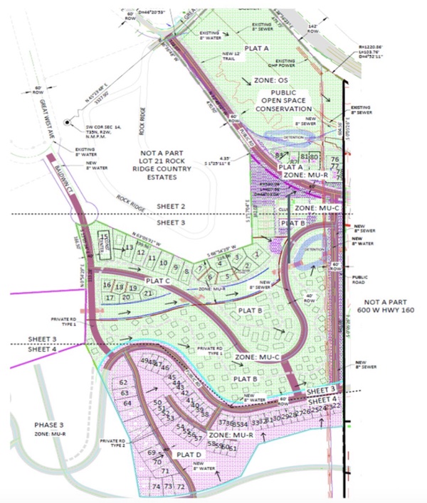
Theoretically, could the development of Ponderosa Mountain, as proposed, make Pagosa Views more feasible by eliminating the need for an intersection at 14th Street?
Would then all of the traffic from a future Pagosa Views development as well be added to Great West Avenue?
Read Part Three… tomorrow…