
The BBC posted an article this week, written by reporter Paige Sutherland and entitled, “The water fight over the shrinking Colorado River”. I guess that officially makes us — the folks dependent upon that same Colorado River — famous.
But does this have to be a “fight”? How about, instead, “The earnest conversation over the shrinking Colorado River”?
A river fulfills many purposes, some of which we might find “necessary” and some “extraneous” to human existence. The presence of trout and other riparian lifeforms might feel indispensable to some of us; to others, a living river might rank as a relatively low priority. Certainly, to the engineers, politicians, and construction companies that designed and funded and built the mighty Hoover Dam, the movement of fish and other aquatic life up and down the Colorado River during various stages of their life-cycles had no importance whatsoever.
The important things were flood control, irrigation, population growth, and electricity generation. To achieve those goals, the natural ecology of the Colorado River had to be sacrificed to create the nation’s largest reservoir, Lake Mead.
For the men who were surveying the site for the Hoover Dam in 1922, the people of the future — the folks living along the Colorado River and its tributaries in 2021 — were figments of their imagination, as-yet-unborn Americans who would benefit from what became, in 1935, the tallest dam in the world. And there’s little doubt that the American West, in general, has flourished as a result of the various dams built during the heyday of the US Bureau of Reclamation, from about 1930 until about 1970.
California’s Imperial Valley, for example, diverts about 2.6 million acre-feet of water annually from the Colorado River — more than the entire state of Colorado pulls from the river (2.4 million acre-feet) and ten times what the state of Nevada diverts from the river.
In return for that diversion, the Imperial Valley produces more than 2/3 of the vegetables consumed in the United States during the winter months, according to the Imperial Valley Farm Bureau website. In 2015, Imperial County farmers produced 1.8 million tons of hay — alfalfa, Bermuda grass, Sudan grass and klein grass — making the region a vital producer of feed for California’s enormous dairy industry, the number one agricultural industry in California and producer of about 20% of the nation’s dairy products.
The Imperial Valley contains about 500,000 acres of irrigated cropland. For comparison, Archuleta County measures about 827,000 acres. (Mostly trees.)
The bloom is off the rose known as the Hoover Dam, however, after the past twenty years of average and below-average precipitation, putting Lake Mead at about 1,084 feet in elevation this week — lower than its 2019 level, and far lower than its 2020 level, at this time of year.
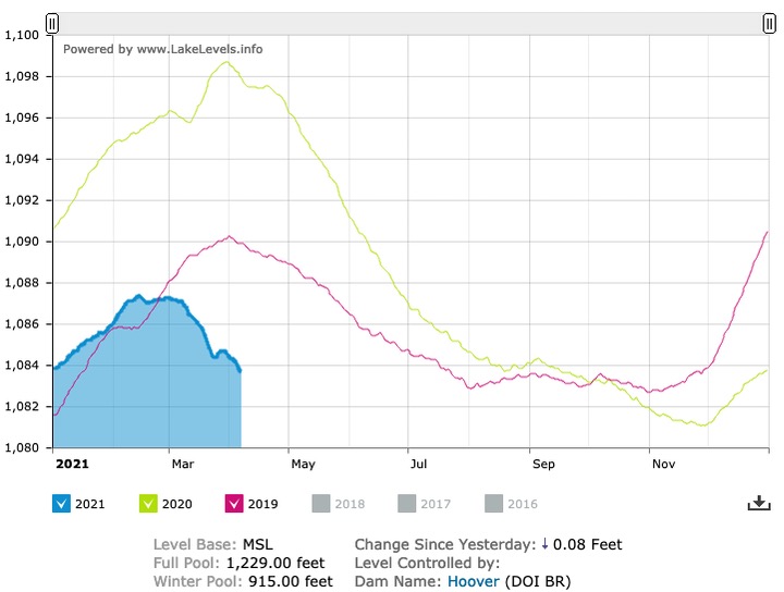
Combined, Lakes Powell and Mead are forecast later this year to hit their lowest levels since the two reservoirs filled decades ago.
These events and conditions may seem far away, but in fact, they could someday affect the way we use water — or cannot use water — here in Archuleta County.
The Upper San Juan Water Enhancement Partnership is currently completing Phrase II of a three-phase “Stream Management Plan” that will have its own suggestions about using — or not using — San Juan River water. I presume that whatever plan this team develops will need to win the approval of several stakeholder groups, starting with the group that consumes 94% of the water diverted in Archuleta County: the agricultural industry.
As I mentioned in a previous installment, I found the presentation by Cynthia Purcell to be the most interesting, in the sense that the data — about some of the agricultural ditches in Archuleta County — seemed the most “down to earth” of the four presentations that day. It’s easy for a person like myself to find data on various websites, or listen to presentations, or read BBC articles… and then give my armchair quarterback’s view of a situation. But Ms. Purcell and her team of researchers reportedly walked 71 miles of agricultural ditches and photographed 500 diversion structures and ditch details, and assembled the information into a spreadsheet (which I hope will someday be publicly available, so I can give another armchair quarterback’s analysis of the final data.)
If you want to watch to the full two-hour WEP presentation, given on March 31, you can do so at the Mountain Studies Institute website.
Meanwhile, the presentation by Lotic Hydrological’s Seth Mason also stood out, in the sense that he shared a generous portion of charts and graphs about “recreational and environmental” data and suppositions related to the San Juan River that will probably take many months to integrate and make sense of.
Note: I currently serve on the San Juan Water Conservancy District board of directors, but this editorial series reflects only my personal perspectives and opinions, and not necessarily the perspectives or opinions of anyone else on the SJWCD Board.
Over the past several decades, new concerns about the Colorado River and its tributaries have developed — concerns that didn’t exist when the Hoover Dam was built. We not only worry about irrigating our food crops, and watering livestock, we now have multi-million-dollar water districts constantly upgrading their treatment facilities to meet the latest Colorado Department of Public Health and Environment regulations, and fixing leaking pipelines that were poorly installed in the 1970s.
On top of those worries, and expenses, the state of Colorado has determined that we need to leave enough water in the stream to allow fish and other aquatic lifeforms to thrive. I’m not sure if the term “thrive” has been conclusively defined.
If that doesn’t provide enough water anxiety, we now need to worry about keeping the water levels high enough so that tourists can float in rafts or tubes while wearing cowboy hats and drinking Lone Star beer.
To make the anxiety problem worse, almost every reporter who writes about water in the American West reminds us that climate change will gradually but inexorably reduce the amount of water in our rivers and streams. (I once found a scientific article that suggested southern Colorado would actually see increased precipitation if the world’s overall temperature increases, but I can never seem to find that article when I want to quote it.)
During our analysis, this year, of a new report by Wilson Water Group concerning San Juan Water Conservancy District water rights, I pulled out my pocket calculator to estimate how much water the average, non-agricultural resident of Pagosa Springs might be using, and found an interesting trend. From my review of PAWSD water sales, it appears that, in 2001, district residents were averaging about 186 gallons per day (GPD) per capita. By 2007, the per capita water consumption had dropped to about 136 GPD.
In 2019, PAWSD sold about 1,237 acre-feet of water to about 10,500 customers. About 105 GPD.
From 2001 to 2019, it would appear that municipal water consumption, per capita, declined by about 4% per year, on average. I find those numbers to be amazing, considering how uncomfortable ‘change’ is for most people, typically.
Does this portend anything about how Americans might deal with water in the future?