
While trying to get a better handle on the current political maneuvering among the states served by water from the Colorado River Basin, I paid a visit to the US Bureau of Reclamation website, and found this map:
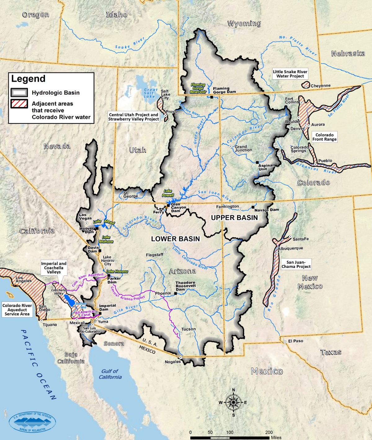
You can click on the map to open a larger version.
The map shows the Colorado River drainage within the gray outlined area, denotes the “Upper Basin” and the “Lower Basin,” and marks the major dams within the basin. The Four Corners — the geographical spot where the four states of Colorado, New Mexico, Arizona and Utah meet — is roughly in the center of the map. And so is Lake Powell, where only two of the eleven boat launches are fully operational.
The map also shows, in red cross-hatching, some of the major metropolitan areas that draw water out of the Colorado River Basin — and put basically nothing back in. Los Angeles, San Diego, Salt Lake City, Denver, Aurora, Colorado Springs, Pueblo, Santa Fe, Albuquerque. If we were to include in that list, Phoenix and Las Vegas — two major cities located within the Basin — we have maybe 29 million non-farmers who help suck the Basin dry each year. Add to those city dwellers, millions of acres of industrially farmed vegetables and fruits and fiber crops, and various industrial “water contractors”… (like the oil and gas industry)… and we end up, in 2019, with a huge political and social problem.
I use the term, “suck the Basin dry” because, once upon a time, the mighty Colorado River flowed freely into the Gulf of California, but lately, not even a trickle makes it to the sea.
On the Bureau of Reclamation’s website (here,) I also found an official statement by the Bureau about the controversial “Drought Contingency Plan” process, which reads, in part:
Since 2000, the Colorado River Basin has experienced historic drought and dry conditions. Currently, the combined storage in Lakes Powell and Mead are at their lowest levels since Lake Powell initially began filling in the 1960s…
On March 19, 2019, the Governors’ representatives of the seven Colorado River Basin States and key water districts formally submitted Drought Contingency Plans to Congress for immediate implementation. The Department of the Interior commends the Basin States and key water contractors on this important milestone…
The Bureau’s web statement also hints at a threat by the federal government to assume control of water distribution in the Colorado River Basin — if the Upper and Lower Basin states did not provided their “Drought Contingency Plans” by March 19 — and a comment that such a threat had been mitigated by the formal submission of each state’s plan. Whether that implied assumption of federal control might have involved the US military is not immediately clear, based on my limited research. But it sure seemed like the water industry in the American West was doing some scrambling to get those contingency plans written and approved prior to the March 19 deadline.

We have a basic problem with water here in the American West, and its partly a problem with poor government decisions. It’s also partly a problem of ordinary human greed and selfishness. Yes, the Colorado River Basin has experienced “historic drought and dry conditions” over the past 18 years — if you define “drought” as meaning “less water than we need to maintain the status quo.” The current status quo, however, has never been fully aligned with the actual patterns of nature, and with the amount of water historically produced by the Colorado River Basin. The Bureau of Reclamation’s two key reservoirs — Lake Mead and Lake Powell — would currently be full to the top, except that human desires have been draining them at an unsustainable rate.
It’s not a matter of “drought” so much as it’s a matter of “we stupidly got ourselves addicted to water.” But of course, the US government, and the state and local governments in the American West, will never admit to stupidity.
As mentioned in Part One of this editorial series, the Bureau operates 338 water reservoirs across the western US, capable of containing (in a good year) 140 million acre feet of water. Most of those reservoirs were built between 1910 and 1970, and they changed what could have been an arid desert wasteland into millions of acres of farmland and growing metropolitan cities.
And golf courses.

According to an article on the AZCentral website:
Government statistics show that golf courses in and around Phoenix consume more water than any other place in the country.
Maricopa County golf courses averaged more than 80 million gallons daily for irrigation, according to a 2010 U.S. Geological Survey report. That is more than double second-ranked Riverside County, which includes Palm Springs, Calif. The report is compiled every five years.
The water used to maintain golf courses like Westin Kierland, in the middle of Arizona’s desert, comes mainly from Lake Mead… and the water in Lake Mead comes down the Colorado River from Lake Powell. As of 2018, Lake Powell was about 1/3 full, the lowest level its been since 1969, when it was still in the filling process. But when the Bureau of Reclamation talks about a “drought” they are actually talking about a level of precipitation that’s very normal for the American West, if you look at the historic and prehistoric data.
When the Colorado River Compact was drafted in the 1920s, however, it was based on barely 30 years of streamflow records. That meager data suggested an average annual flow of 17.5 million acre feet past Lee’s Ferry. Since then, modern studies of tree rings revealed that those three particular decades were probably the wettest in the past 500 to 1,200 years — and that the natural long-term annual flow past Lee’s Ferry is probably closer to 13.5 million acre feet. So the Colorado River Compact has resulted in more water being allocated to river users — farmers, cities, golf courses, oil companies — than actually flows through the Colorado Basin. Especially since 2000, drought conditions have exacerbated the issue of water over-allocation.
Following the November 2018 elections, Colorado activist Gary Wockner wrote an opinion piece about the Colorado Water Plan, and we published his thoughts here in the Daily Post. There’s a kind of consensus among the big players in the Colorado water industry that the 2015 ‘Plan’ represents a workable solution to the future management of Colorado’s numerous rivers — nearly all of which flow beyond Colorado’s borders and into neighboring states… and Mexico.
The Plan refers to itself as the “largest civic engagement process in our state’s history.”
One of the details the ambitious Plan failed to thoroughly plan for, however, was funding. Putting a very expensive plan into effect, for example, naturally suggests that we pay for its implementation. Who pays for that? It’s one thing to get hundreds and hundreds of citizens to offer suggestions about the future of our water resources. It’s quite a different matter to get them to agree to pay for implementation…