
John Wesley Powell told us, back in the 1870s, that the American West was an arid land, and that drought conditions were common. Surely, he would never in his wildest dreams imagine 40 million people, and 5 million acres of farmland, drawing water from the Colorado River. Nor could he have imagined, I suspect, a dam the size of the 710-foot-tall Glen Canyon Dam, nor the creation of a reservoir the size of Lake Powell — visible from space.
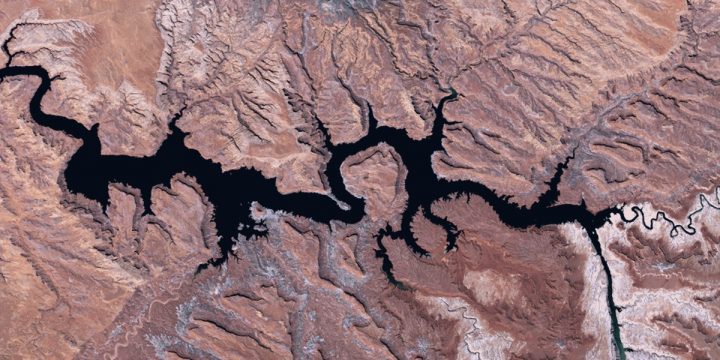
Here’s how Lake Powell looked in 1991 at the beginning of a three-year drought, when the water level was about 80 feet below maximum.
The water elevation at Powell has sunk about 94ft since 2000. Although the lake has seen years of high and low river flows during the past two decades, one of the main reasons for the current low water levels is political, not environmental. Since 2007, Lake Powell has been drained regularly and purposely to keep Lake Mead, downstream, from sinking to an elevation of 1,075ft, the point at which the federal government must declare a water shortage under a 2007 agreement. This would cause mandatory water delivery cuts to the Lower Basin states, triggering widespread water rationing.
Another reason for the low water levels, which is rarely talked about by the water industry, has to do with natural water loss. Lake Powell can hold a maximum of about 25 million acre feet of water, but the rock beneath the lake is sandstone, and it leaks like a sieve. The reservoir also loses a massive amount of water to evaporation. Between those two natural processes, Lake Powell manages to leak and evaporate away about 6 percent of the entire annual flow from the Colorado River. That’s more water than the state of Nevada draws out of Lake Mead each year.
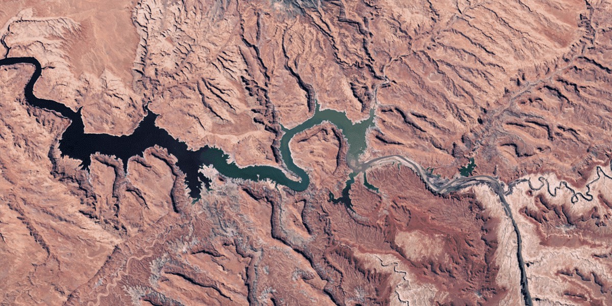
Here’s Lake Powell in 2015, when it was about 50 percent of “full pool.” (Last year it dropped to about 38 percent full, I understand.)

On Tuesday, Colorado’s US Senators Michael Bennet and Cory Gardner introduced the bipartisan, bicameral Colorado River Drought Contingency Plan Authorization Act “to ensure the wide-reaching Drought Contingency Plan forged between the seven Colorado River Basin states and Indian tribes can be implemented without delay while fully respecting important environmental protections in the process.”
The bill was introduced simultaneously in the House of Representatives.
From the Senators’ joint press release:
“The Colorado River is the lifeblood of our economy, but in recent years we’ve experienced some of the worst drought conditions in centuries.” Bennet said. “Years of hard work from individuals across seven states have gone into developing the Drought Contingency Plan to respond to this drought and avoid the most severe consequences… We must act quickly to safeguard Colorado’s agricultural and outdoor recreation based economy…”
We’re not sure what the most severe consequences might be. Farmers who can no longer farm? Dams that can no longer generate electricity?
The press release concludes:
The Drought Contingency Plan was negotiated between the seven Colorado River Basin States and Indian tribes to respond to this prolonged drought. It is designed to protect Lakes Mead and Powell from reaching certain critical water elevations that would trigger severe water supply reductions and hydropower impacts, including the risk of reaching crises levels where operational control of the Colorado River System is lost.
I’ve been following the ups and downs of the Colorado water industry for the past decade, and this might be the first time I’ve heard the suggestion that “operational control of the Colorado River System” might be lost. I’m not sure exactly what that means. We’ve never had “operational control” of the amount of water contributed to the river by Mother Nature. On the other end of things — the way we use the water we’re provided — that’s been a constant stream of compromises.
“40 million people in the western United States depend on the health of the Colorado River to provide water for agricultural, municipal, and consumptive use,” Gardner said. “The river also supports a growing recreation economy. However, in the face of long term drought, the basin states have come together to create coordinated plans that should aid efforts to prevent severe water shortages in the west and stabilize water storage levels at Lake Mead and Lake Powell. I congratulate the states on the successful collaboration that has produced this plan…”
The chart below was constructed by scientists who analyzed “tree rings” going back to the year 762. Their theory is that trees always grow faster when we have above-average precipitation, and grow almost not at all during a drought. In the chart, they drew a dotted line at 15 million acre feet, the amount of water believed to be the “average annual flow” of the Colorado River – believed, that is, in 1922 when the Colorado River Compact was signed by the seven states sharing water from the river.
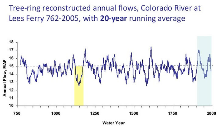
The 1922 agreement came in the midst of one of the wettest periods in recent history for the American West. As you see in the chart, the analyzed flow of the Colorado is generally less than 15 million acre feet – and very often precipitously less. But to this day – April 4, 2019 – the political decisions in Congress and among the seven Colorado Basin states appear to be consistently based on 15 million acre feet.
But with all this talk about water, it would seem that the central issue in the controversial Drought Contingency Plan — now being considered by the US Congress — is not really ‘water’ at all. It’s hydroelectricity. The Hoover Dam produced more than 10 TWh (trillion watt hours) of electricity in 1984. In 2015, due to lower water levels, the production was only 3.6 TWh. If the lake level drops below 1,050 feet elevation, the dam will no longer be able to generate power.
The Glen Canyon Dam, on Lake Powell, generated 8.7 TWh in 1984. In 2005, the dam was able to generate only 3.3 TWh. If the reservoir elevation drops below 3,490 feet, there won’t be enough water flowing through Glen Canyon Dam’s turbines to generate power.

Those elevations are the ones referenced in the 2019 Drought Contingency Plans and in previous attempts to maintain “operational control of the Colorado River System.”
But even though both reservoirs are currently at nearly record-low levels, both must continue to release water, for several reasons. Obviously, both release water when they’re producing electricity. Lake Mead must release water to fill the numerous aqueducts that serve Arizona and California, and for environmental reasons, to preserve plant and animal life in and along the river. Lake Powell is legally required to release water to keep Lake Mead above 1,050 feet elevation, and to maintain some kind of water level in the Grand Canyon, for environmental and recreational needs.
In the face of all these problems, the population of the American West keeps growing. And our governments keep promoting that growth…