
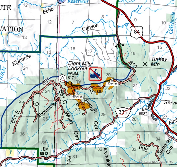
The Pagosa Ranger District is planning prescribed fire operations on Thursday, October 8, pending all required approvals and favorable environmental conditions. This project is located six miles south of Pagosa Springs on the top of Eight Mile Mesa between the communities along County Road 335/Lower Blanco and Loma Linda. Fire managers will be targeting roughly 250 acres of the total 579 acres available in the project area. Smoke will be visible from U.S. 160, U.S. 84, downtown Pagosa Springs, Loma Linda, and County Road 335/Lower Blanco.
Sign boards with information will be at the base of 8-Mile Road, Loma Linda subdivision and CR335.
The Forest Service will be placing several smoke monitors at locations around the fire and are communicating with Archuleta County Public Health for sharing information about smoke. Officials do expect smoke to settle on the Highway 84 corridor overnight and CDOT will have signage on Highway 84. Forest Service does expect smoke to linger for a day or two post burn.
This fuels reduction work is immediately adjacent to two subdivisions and is a critical step in protecting lives and property from unwanted fire in a landscape prone to lightning-caused wildfires. The Eight Mile Prescribed Fire will build upon mastication work funded by the Rio Chama Collaborative Forest Landscape Restoration Program (CFLRP) completed in 2022, as well as thinning work from 2023. These efforts on the mesa top complement critical defensible space work on adjacent private lands being implemented by partners including Wildfire Adapted Partnership, San Juan Headwaters Forest Health Partnership, as well as others.
While the summer was hot and dry, fall has brought cooler temperatures, higher relative humidity, and significant rainfall. Prescribed fires are often implemented on the cusp of wildfire season to effectively consume the targeted vegetation. We use prescribed fires to help reduce overgrown vegetation to help protect local communities, infrastructure and natural resources from wildfires. The forests in Southwest Colorado are part of a fire-adapted ecosystem, which has historically experienced frequent, low-intensity fires on a large scale. Prescribed fire replicates that fire regime under controlled conditions.
We will evaluate weather conditions in the hours before a burn begins. If conditions warrant, scheduled prescribed fire activities may be canceled.
Project maps and additional details can be found on the 2026 San Juan National Forest Prescribed Fire Program page.