
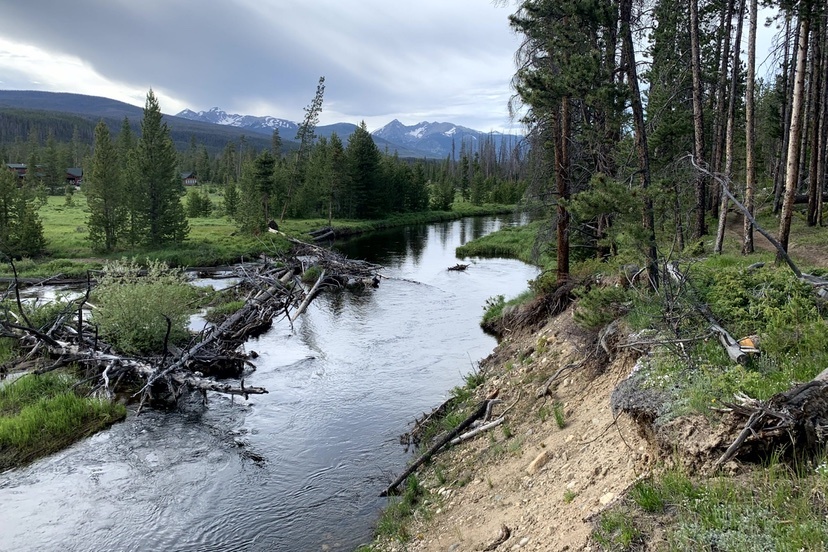
Photo: Headwaters of the Colorado River.
This story by Allen Best appeared on BigPivots.com on February 17, 2026, with the headline ‘Compromise is so terribly, terribly hard’. We are sharing it in three parts. Read the complete article here on Big Pivots.
The Bureau of Reclamation issued five alternatives in its draft environmental impact statement for how it will operate Glen Canyon Dam. The federal government can implement only two of them, according to Jim Lochhead, former CEO of Denver Water. Those two are deeply flawed. The first is “no action”, and the second would impose shortages on Arizona and Nevada approaching 7 million acre-feet. Both alternatives would almost certainly be challenged in court. Both would quickly result in Lake Powell reaching deadpool with compact litigation and unspecified federal actions in the upper basin to protect Powell.
The three other alternatives contain the essential elements of an agreement among the states, he said, including up to four million acre-feet of shortages in the lower base, but not by priority, and leaving pools in the two big reservoirs for conserved water by both upper and lower basins.
“Not surprising, the alternatives with the highest shortages in the two basins and the greatest flexibility perform the best again potential hydrology that illustrates the magnitude of the problem we’re in, and the actions required by both upper and lower basins to address it,” he said. For any of this to work, he added, “we need long-term funding to mitigate the impacts and build resilience in both basins.
A brief recent history
Lochhead also sketched a brief history of agreements during recent decades on the Colorado River. His excerpted comments follow:
This slide shows the combined contents of lakes Powell and Mead for the last 25 years juxtaposed against some of the key events and agreements that have occurred during that 25-year period.
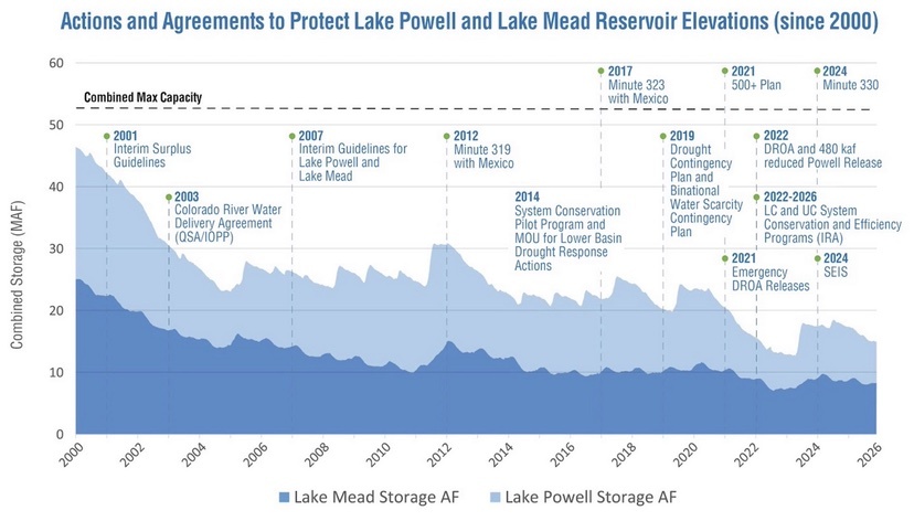
Despite the best efforts of the states, reservoir levels have continued to decline over time. The states, though, have made important agreements and have significantly reduced uses in response to changing conditions on the river. But clearly, much more needs to be done.
Starting in the early 1990s we had 10 years of negotiations that led to Federal Surplus Guidelines in 2001. You can see, at the beginning of this century, the reservoirs were virtually full, and we were arguing about surpluses.
Those guidelines also contained a deadline for California to finalize and implement the Quantification Settlement Agreement among California agencies to define priorities and implement ag-urban transfers necessary to get California’s water use from 5.3 million acre-feet a year down to 4.4 million acre-feet a year. The negotiations were driven by the direct involvement and pressure from Secretary (Bruce) Babbitt and his team at the Department Interior. That’s a theme — federal pressure being necessary to agreements of the Basin States over the last 25 years.
The California agencies had to come together and agree on how they were going to reduce their use by 800,000 acre-feet. They couldn’t reach agreement, and so Interior imposed limitations on water use in the Imperial Valley, prompting litigation that was eventually settled in 2003.
Lochhead credited Interior Secretary Gayle Norton and Bennet Raley, the assistant secretary for water, for pushing California to this agreement. Both, incidentally, were Colorado natives, Norton from Denver’s northern suburbs and Raley from southwest Colorado. Upon Raleys’ departure from the Interior in 2004, the Los Angeles Times had this to say:
“Raley may be remembered best as the folksy but firm bureaucrat who finally made good on the federal government’s long-standing threat to put California on a water diet. He did it by forcing the state to agree to stop using more than its share of the Colorado River, freeing up water for other Western states.”
Despite the arguments about surplus waters in the 1990s, some observers could see troubles ahead of a river overcommitted. Troubles arrived in a big way with the water-poor year of 2002 — a runoff that may turn out better than this year’s.
Lochhead recalled that the upper-basin states, wanting to maintain storage in Lake Powell, asked the Interior Department — the operator of the dam — to release less than 8.23 million acre-feet from the reservoir. Lower-basin states, primarily Arizona, resisted. Difficult meetings ensued, litigation was threatened, legal war chests were readied — then Norton interceded, issuing a deadline by the end of 2007 for an agreement about lower basin shortage guidelines and operational guidelines for releases of water from Powell and Mead.
The states met that deadline — unlike those of the last year — and the guidelines helped. But, said Lochhead, they have proven, over time, to be inadequate. It seemed like every year we were one foot over or under, those triggers that caused distrust and accusations between the upper and lower basins of gaming the system.
Meanwhile, the river produced less than anybody had expected. The states agreed to additional interim measures, and they, too, proved inadequate.
In 2019, the states agreed to a drought contingency plan and drought response agreement, more interim measures designed to protect the system’s major reservoirs from falling to critically low levels. The lower-basin states agreed to plan that added an extra layer of protection. The goal was to maintain a half million acre-feet of water in Lake Mead.
Lochhead showed a chart of water use in the lower basin but with caveats. It did not include the tributaries, including the Gila River — a conversation unto itself. Nor does it show reservoir evaporation and losses, which add up to about 1.5 million acre-feet annually, what is often called the structural deficit.
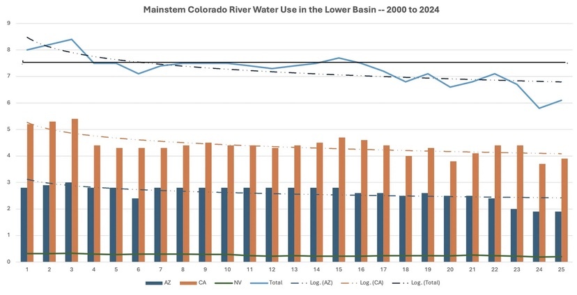
The blue line at the top showed a significant reduction in use starting in 2001, then a fairly steady use of about 7.5 million acre-feet until about 2017, when withdrawals begin to drop due to shortages.
The next slide showed the variations of use by the upper-basin states. The chart shows ups and downs, which can be attributed to wetter and dryer cycles. Overall, though, water use in the upper-basin states has remained fairly constant. Those uses, he added, do not include reservoir evaporation — because those losses are explicitly included in upper-basin consumptive use.
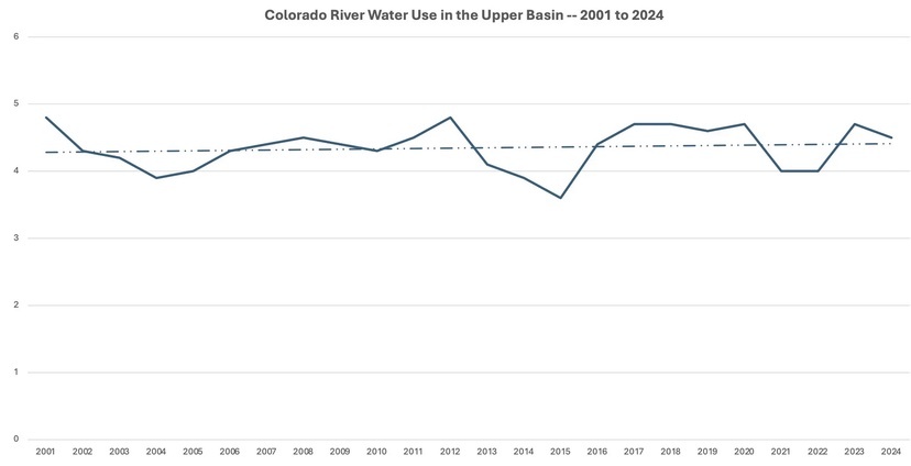
“Part of the argument, part of the confusion, comes from these different accounting methodologies in the upper and lower basins,” he said.
The upper basin has made a couple of arguments. One is that the upper basin has the right to develop more water, up to 7.5 million acre-feet, but also that hydrology is the limiting factor. Users suffer shortages every year. I’m not sure you can have both.”
Again, hydrology is the limiting factor.
Allen Best publishes the e-journal Big Pivots, which chronicles the energy transition in Colorado and beyond.