
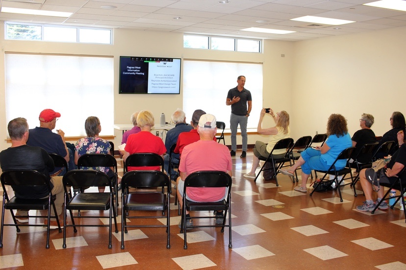
Photo: ‘Pagosa West’ public presentation at the Community Center, hosted by architect Brad Ash and the Pagosa Springs Community Development Corporation, August 19, 2025.
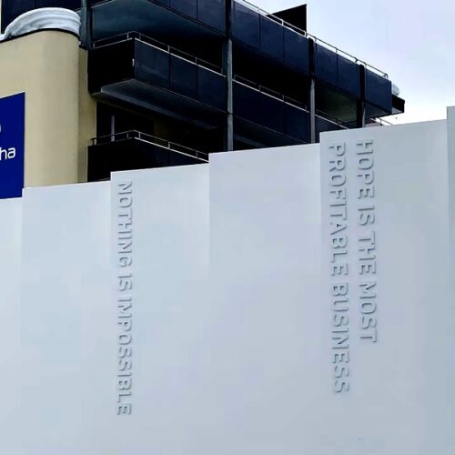
One of our humor writers, Louis Cannon, shared a photograph in a column last year, displaying a message posted by the United Arab Emirates (UAE) outside their pavilion at the 2024 World Economic Forum.
The message:
“Hope is the Most Profitable Business”
We witnessed a couple of versions of ‘hope’ at the August 19 and 21 presentations by Pagosa architect Brad Ash at the Ross Aragon Community Center.
Mr. Ash has been retained by Montrose, Colorado-based ArenaLabs LLC, to help design a proposed mixed-use subdivision on 100 acres across from the City Market shopping center, on the opposite side Highway 160.
No doubt ArenaLabs LLC and Reynolds Ash & Associates hope the ‘Pagosa West’ subdivision can be approved by the Town government at some point, and can generate a generous profit for both businesses.
Another type of hope was evident at the August presentations, emanating from the 20 or so neighbors to the proposed subdivision… a hope that the design will not detract from the enjoyment currently experienced by the nearby rural residents, in terms of wildlife, scenic views, peace and quiet, and a generally rural environment.
Several years ago, the Town government updated its Land Use and Development Code (LUDC) to require an additional review process for proposed subdivisions: The Sketch Plan Review. This preliminary review process is meant to allow a developer to obtain approval of the ‘general concept’ of a new subdivision before the developer starts spending tens of thousands of dollars on engineering and design. Two other approvals — Preliminary and Final — are also needed.
ArenaLabs LLC did bring a ‘Sketch Plan’ to the Town Planning Commission back in March, 2025, and the Planning Commission tabled the approval, suggesting that ArenaLabs and Reynolds Ash bring back something more suitable as a concept. Mr. Ash admitted, at the August presentations, that the March 2025 design had neglected to take into consideration the existing trees, vegetation, wildlife corridors and other topological aspects of the site, but had instead simply been overlaid the existing zoning.
None of the landscape features were shown or highlighted on the initial maps.
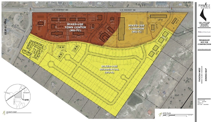
The existing zoning was created many years ago by a volunteer group, based on criteria that may or may not be applicable to the community’s needs in 2025.
Unfortunately for the neighbors, the Pagosa Springs Town Council and the Town Planning Department have already established a close partnership with ArenaLabs, prior to any plan approvals and prior to ArenaLabs even owning the property in question. In partnership with the ‘Pagosa West’ developers, the Town government obtained a $1.9 million grant from the Colorado Department of Local Affairs to help subsidize infrastructure at ‘Pagosa West’ — with the understanding that the development would include 96 units of “workforce housing” in a complex centrally located on the 100-acre parcel.
You can download that grant application document here.
According to Mr. Ash on August 21, the 96 units has now become 88 units, and the housing complex has been located closer to the development’s rural neighbors, and the three-story structures might be partly two-story.
And all of the indications of where anything else might be located on the 100-acre parcel — save for a corner gas station and a couple of streets — have been removed from the plan.

Here’s a quote from the ‘Pagosa West’ website:
“With a mix of modern homes, dynamic commercial spaces, and thoughtfully designed amenities, Pagosa West offers something for everyone…”
In fact, the map shared by Mr. Ash last week told us almost nothing about what ArenaLabs LLC plans to do with the property.
This may pose a problem for the Town Planning Commission, because the LUDC requires the following determinations to be made prior to a ‘Sketch Plan Approval’ (LUDC Section 2.2.4):
Approval criteria. The Planning Commission shall evaluate the applicant’s sketch plan application to determine whether:
The proposed subdivision complies with all applicable use, density, development, and design standards set forth in Articles 4, 5, 6, and 7 of this Land Use Code that have not otherwise been modified or waived pursuant to this Chapter and that would affect or influence the layout of lots, blocks, and streets. Applicants shall avoid creating lots or patterns of lots in the subdivision that will make compliance with such development and design standards difficult or infeasible.
The general layout of lots, roads, driveways, utilities, drainage facilities, and other services within the proposed subdivision is designed in a way that minimizes the amount of land disturbance, maximizes the amount of open space in the development, preserves existing trees/vegetation and riparian areas, protects critical wildlife habitat, and otherwise accomplishes the purposes and intent of this Land Use Code…
The applicant has provided evidence that provision has been made for a public water supply system or, if other methods of water supply are proposed…
The applicant has provided evidence that provision has been made for a public sewage disposal system or, if other methods of sewage disposal are proposed…
The applicant has provided evidence to show that all areas of the proposed subdivision that may involve soil or topographical conditions presenting hazards or requiring special precautions…
In my humble opinion, none of these determinations can possibly be made, based on the map that Mr. Ash shared with the public on August 19 and 21, with the possible exception of preservation of riparian areas.
The development of subdivisions in Archuleta County has — again, in my humble opinion — been consistently botched by our local governments, leading to the creation of hundreds of miles of failing infrastructure — roads, streets, water lines, sewer lines — that the tax base cannot support.
Within a few hundred feet from the proposed ‘Pagosa West’ subdivision are acres and acres of vacant, undeveloped commercial and residential parcels.
‘Pagosa West’ is not “needed” by our community, at this point in time. Especially, a subdivision that presents itself as 100 acres of vacant property cross-crossed by more miles of infrastructure that our community cannot afford to maintain, is not “needed” by the community.
Unfortunately, our Town government decided to create a partnership with this development even before a subdivision application was submitted.