
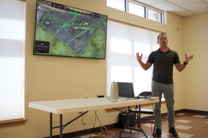
Photo: Architect Brad Ash presents a ‘subdivision map’ with remarkably little subdivision information, at a August 21, 2025 public meeting at the Ross Aragon Community Center.
I found the August 21 presentation of the proposed ‘Pagosa West’ subdivision to be encouraging, in one sense.
Instead of requiring questions and comments to be submitted in writing, and placed in a basket, to be shared later with “the experts” (the proposed developers) — as we had been instructed at an earlier August 19 presentation — the presenter, architect Brad Ash, fielded questions directly from the 20 people in the audience.
And the audience did indeed have questions.
But a couple of things, I found to be discouraging about the presentation. More about that later.
Yesterday in Part One, I summarized the May 2024 meeting of the Archuleta Board of County Commissioners (BOCC), where realtor Shelley Low and developer Doug Dragoo made their best effort at convincing the commissioners to purchase five acres across from the Pagosa Springs Medical Center on S. Pagosa Boulevard, for a future County Administration Building. They told the commissioners that the Dragoo family — which had not yet purchased the property from Kisco LLC — planned to build 120 units of ‘workforce housing’ apartments adjacent to the Administration Building, aided by a $2 million grant obtained from the Colorado Department of Local Affairs by the Town Planning Department and Town Council, on the Dragoo’s behalf.
Here’s a map showing — in green — the five acres offered to the BOCC. And in pink, the 3.5 acres suggested for 120 units of ‘workforce housing’.
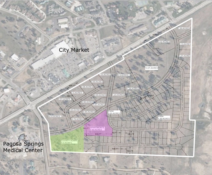
The BOCC considered the offer, but about six months later, voted to purchase, instead, 5 acres in the nearby (and already developed) Aspen Village mixed-use subdivision as the site for a future Administration Building. One of the main considerations for the BOCC was the lack of infrastructure at ‘Pagosa West’.
The Dragoo family continued their efforts to get other people to pay the cost of their proposed development, and they approached the Town Council with a request to allow the Dragoos to form one or more developer-controlled governmental units — so-called ‘metropolitan districts’ — on the 100-acre parcel, so that the future residents of the subdivision would pay for the development costs along with the accompanying interest payments on the development bonds, thus greatly enhancing the potential profits for the Dragoo family, and placing the long-term financial risks on the shoulders of the future residents.
The Town Council, in its wisdom, declined to allow the metro district scheme.
In the meantime, the development — now officially labeled as ‘Pagosa West’ — developed a website to market the subdivision (which does not yet have approval…) on property the developers do not yet own. They presented a fairly detailed map to the Town Planning Commission for a preliminary ‘sketch plan’ approval.
A fairly large number of the neighbors showed up to protest the layout of the planned mixed-use subdivision. Not a single neighbor spoke in favor of the plan as presented.
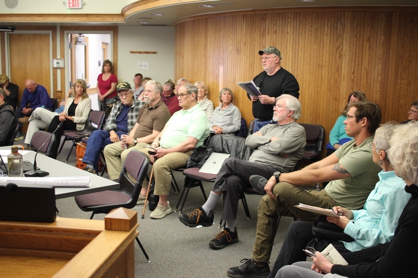
When the development came before the Town Planning Commission for its sketch plan approval, a few things had changed from the previous summer.
1. The southwest corner, where the County Administration Building had previously been indicated, was now the site of four three-story apartment buildings.
2. The map now showed a gas station at the northwest corner, and numerous commercial buildings along the north part of the property, where the Town had zoned the property as “Mixed-Use Town Center” and “Mixed-Use Corridor”.
3. The commercial development spilled into the “Residential” zoning at the far northwest corner.
4. The residential parcels along the southern boundary had been reduced from 1/3 acre lots down to 1/6 acre lots.
5. One of the heavily-treed areas, featuring some of the most mature pine trees in the town, showed storage units and a storage warehouse.
As mentioned, the neighbors were generally unhappy with the proposed sketch, particularly with the proposed high-density residential adjacent to existing low-density residential… and yet another the gas station at the Pagosa Boulvard intersection.
The green areas in the following map are private parcels outside the proposed subdivision.
The Planning Commission appeared to take the public’s objections seriously, and voted to table the sketch plan approval, directing the developers to come back with an improved plan.
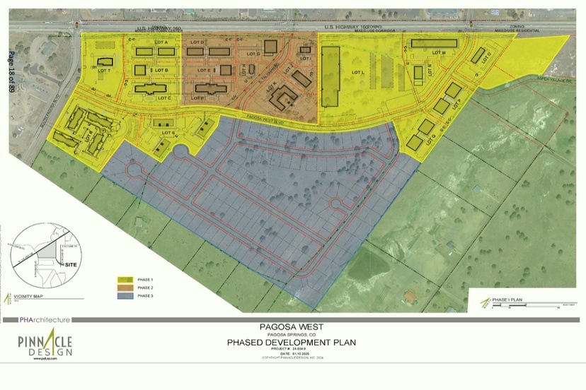
It was supposedly the ‘improved plan’ that was shared with the community on August 19 and 21 at the Ross Aragon Community Center.
I use the term “supposedly” because the plan was not really a plan at all. It was basically a blank map of where a plan might be, someday.
This “Master Plan” map was represented by architect Brad Ash as the ‘plan’ that will be presented to the Town Planning Commission later this summer or in the fall. The pink area shows a possible ‘professional workforce’ housing project — two-story and three-story buildings — and the yellow area shows the planned gas station. But all of the residential parcels have disappeared, as have all the commercial parcels.
Also missing are nearly all of the streets.

I’ve been reporting on subdivision approvals in Pagosa Springs since 2005, and I have never seen a subdivision proposal so lacking in useful information as the Pagosa West map shown to the public on August 21.
Of course, I can fully understand why a developer might present such a map. The last time ArenaLabs LLC presented their subdivision map at the Town Planning Commissioner — showing all the proposed parcels and streets — the public loudly protested some of the details illustrated on the map.
By showing a map without any information, the developers can leave everyone in the dark about the subdivision details, and thereby reduce the ability of the public to point out problems and issues.
When I mentioned to architect Brad Ash that I had never seen a subdivision proposal that failed to indicate where the subdivision parcels will be located, he replied:
“There will be parcels, but they’re going to be large parcels for the time being. We don’t know, moving forward, what those are… The maximum density that we [showed on previous maps]…”
Hudson: “But you will be showing the [individual] parcels when you present to the Planning Commission?”
Ash: “It’s going to be the Mixed-Use Town Center Parcel, the Mixed-Use Commercial Parcel and the Residential Parcel.”
Hudson: “So you’re not going to show how big the [individual] parcels are?”
Ashe: “No, we’re going to learn from the utility companies what the [maximum allowable] development is. But we’re not going to [build to the maximum density]…
“We don’t understand the impacts. We’re waiting for the utility companies…”
This appears to be a rather serious case of misinformation.