
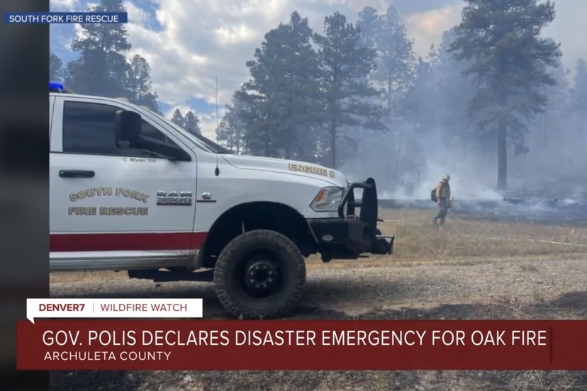
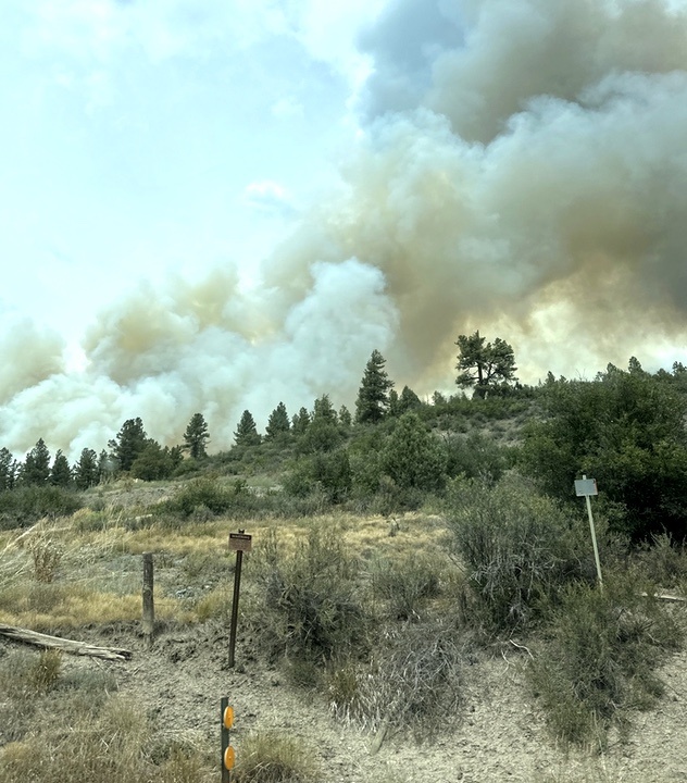
The Oak Fire is currently burning in the Aspen Springs area about 10 miles west of downtown Pagosa Springs and a few miles west and southwest of the Pagosa Lakes neighborhoods. It apparently started Sunday afternoon, August 10, as a structure fire at 38 Spruce Circle, in Aspen Springs Unit 1, and had grown to 150 acres by 7pm Sunday night. Evacuations were ordered within one mile of 38 Spruce Circle, which includes all of Unit 1 and parts of Unit 2, 3 and 4, plus the Elk Meadows/Elk Park subdivisions to the east. Aircraft are helping ground crews to control the fire.
Gov. Jared Polis has reportedly issued a verbal disaster declaration, freeing up state and federal resources for the Oak Fire.
According to a posting by the Archuleta County Sheriff’s Office, “Any residents outside of the one mile radius are on evacuation notice.”
Information posted to the nonprofit website WatchDuty suggest that fire activity was expected to quiet down during the night.
This map shows Unit 1 tinted pink, and 38 Spruce Circle tinted red. US Highway 160 runs across the bottom of the map. Click to enlarge the map.

The Emergency Call Center number is 970-422-7084.
From WatchDuty:
Pagosa Springs High School will be an overnight shelter for those unable to return home. RVs and camper trailers are welcome in the parking lot of the high school. Household pets may shelter at the Humane Society of Pagosa Springs.
From the Sheriff’s Office:
MANDATORY EVACUATIONS. Archuleta County Sheriff’s Office has ordered a mandatory evacuation for residents of Aspen Springs to Elk Park Subdivision due to Fire. This notice affects all residents and businesses from Spruce Circle in Aspen Springs to Elk Park Subdivision. All of impacted areas that are under MANDATORY evacuation are NOT accessible.
Crews continue to work in the area with additional resources joining the efforts.
EVACUATION CENTERS: Pagosa Springs High School; Humane Society Animal Shelter, 465 Cloman Blvd. is available to take small animals. The Archuleta County Fairgrounds, 433 Hwy 84, Pagosa Springs, is available to house livestock. Owners are urged to plan transportation, prepare leads and halters, and bring containers for food, water, and any necessary medications.
PRE-EVACUATION NOTICE: for all residents along US Highway 160 to North Pagosa Blvd up to Martinez Place, approximately 1 mile up North Pagosa Blvd.
Pre-Evacuation is a notice for you to start getting ready to evacuate. This is your opportunity to gather your belongings, your photos etc. Get your medications ready, have your prescriptions refilled if you need to. Have a medication list with your medication numbers listed, in case you are displaced and need to have your medication refilled. Also, it is very important to have your important paperwork together. Insurance documentation, birth certificates, bank information, and other documentation that is important to you. Make plans for your pets, and your livestock. If you don’t want your animals to go to an animal shelter, start moving them now to a location of your choice. You may not have time to do it if they issue an evacuation notice.
Middle Mesa Fire
The Middle Mesa Fire is burning in New Mexico, just south of the Southern Ute Indian Reservation, and east of Navajo Reservoir.
Acres: 5,050
Start Date: August 1, 2025
Location: 22 mi. west of Dulce, NM
Cause: Lightning
Personnel: 440
Fuels: Timber and brush
Containment: 27%
Resources: 7 crews | 28 engines | 3 helicopters | 4 bulldozers | 7 Water Tenders
Highlights: High winds caused trees to torch and increased fire activity on the northeast and southeast sides of the fire near containment lines. Containment lines continue to hold through the winds. Aerial operations supported ground resources with bucket drops just south of Trujillo Road in Carracas Canyon. Containment has increased to 27%.
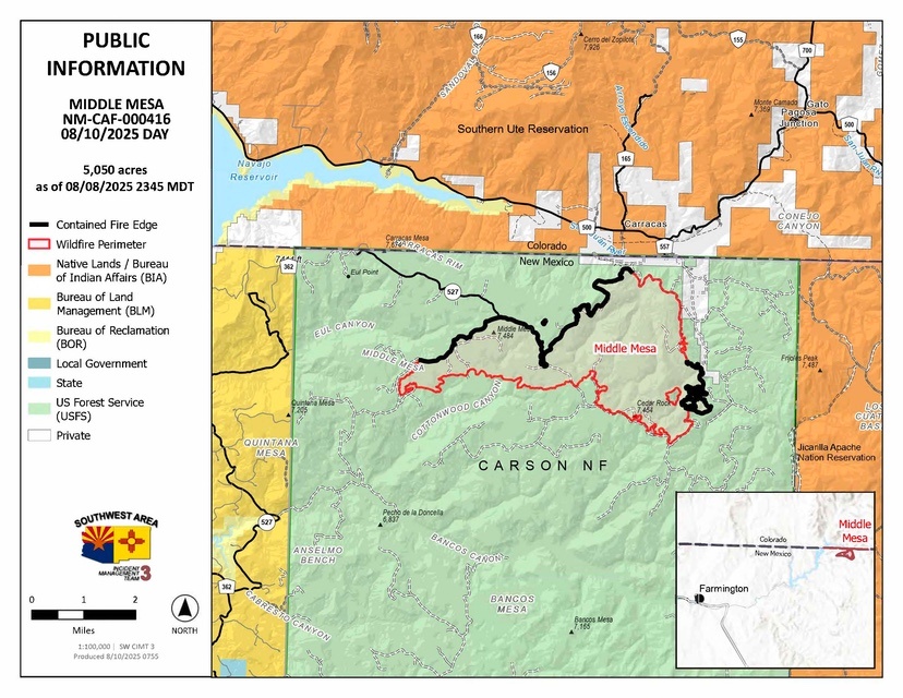
Operations: Yesterday, containment was added along Forest Road 218A on the north side of the fire. Crews continued mopping up the northeast and southeast sides of the fire. Stagnant hot and dry conditions fueled activity and caused interior pockets of green trees and brush to burn, producing light smoke throughout the day Saturday. Near Alamo Canyon, firefighters continued patrolling and extinguishing heat, taking advantage of lower winds. Patrols also continued on the western perimeter of the fire, where fire activity is minimal. Today, firefighters will continue working in all areas of the fire to extinguish heat near the firelines. Engines and water tenders are supporting crews by delivering water to aid in the mop up operations. Fire managers are being thorough in this effort as any wind can create flareups and a single ember blown outside of the lines could cause challenges. They are also working side-by-side with Resource Advisors to avoid disturbing cultural sites. Additional resources from the Middle Mesa Fire are ready to respond to any new fire starts in the area.
Weather: There is a 20% chance of dry thunderstorms today. Thunderstorms can bring gusty and erratic winds in excess of 45 mph. High temperatures will be in the 90s with low relative humidities as dry conditions continue. Winds will also be breezy in the afternoon and early evening. There are increasing moisture and thunderstorm chances Monday and Tuesday which could bring dry lightning.
Smoke: For smoke information: https://www.env.nm.gov/air-quality/fire-smoke-links/
Closures: There are no forest closures in effect. However, out of public and firefighter safety the public is urged not to go into the fire area.
Evacuations: For evacuation information: https://www.rio-arriba.org/departments_and_divisions/sheriff.html
Safety: Drivers should use caution when traveling near the fire area. Drivers are asked to be mindful of firefighting equipment and resources around the fire area. As activity increases throughout the afternoon, smoke may impact nearby roads. Drivers should use caution when traveling around the fire aera.