
Going forward it is expected the WUI will continue to expand; an anticipated amenity-seeking migration of retiring baby-boomers to smaller communities with lower costs of living close to scenic and recreational natural resources will contribute to WUI growth…
— from ‘Wildland–urban interface’ on Wikipedia.
I personally find the Jackson Mountain Landscape Project fascinating, in terms of the environmental effects potentially layered into the landscape.
And the very use of the term, ‘Landscape’ is also fascinating. What other term could possibly apply to a project that potentially includes logging, fuels reduction, the creation of 40 miles of mountain bike trails, a silviculture project, parking lots, restrooms… and a gravel pit?
Although the proposed Archuleta County gravel pit may have generated the most concern, especially among the property owners in the San Juan River Village — understandably enough — the possibility of logging and ‘fuels management’ throughout the project could have equally important results for those same property owners.
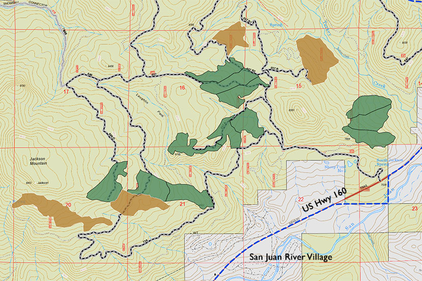
Here, again, is the map of possible vegetation treatments, as shared on the Jackson Mountain StoryMap website.
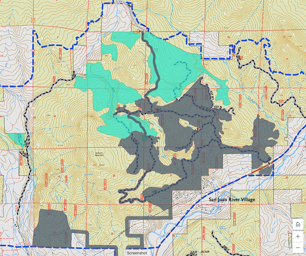
I believe the gray area on this map is the 2,000 acres of potential “fuels treatments such as mowing, mastication, chipping, and hand thinning” that would reduce density of shrubs and smaller trees to provide conditions where “fire can move naturally on the landscape, and give fire managers more opportunities to safely manage fires in the area.”
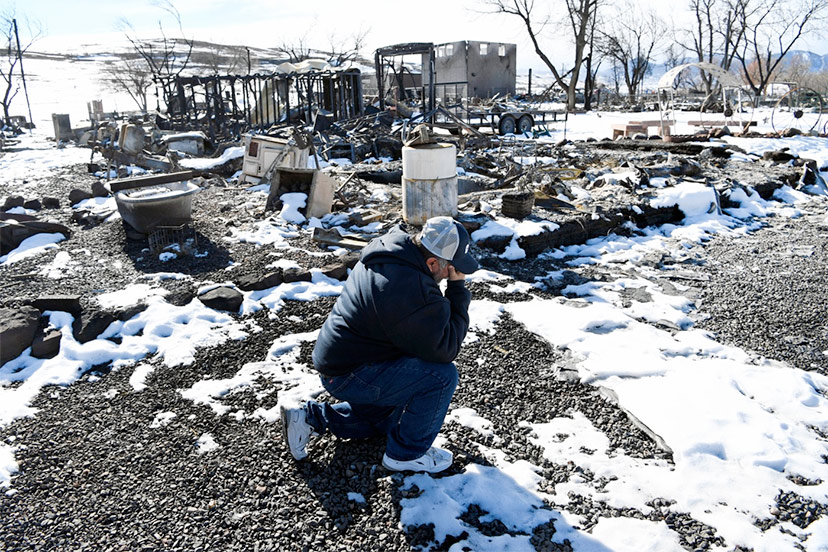
We can see that the ‘fuels treatments’ cover much of the forest immediately north of the San Juan River Village subdivision. At some point — if history provides any indication — the forest on Jackson Mountain will be subject to wildfire. Maybe next year; maybe many, many years from now. If the Forest Service can afford to perform a ‘fuels treatment’ every ten or twenty years, it might ultimately save the San Juan River Village from someday looking like this:
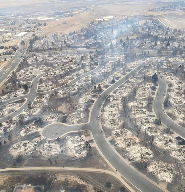
That’s a photo of a subdivision neighborhood south of Boulder, Colorado, following the 6,000-acre Marshall Fire in December 2021. This was not a heavily forested area; the wildfire spread mainly over grassland during a period of exceptionally high winds, but the homes themselves provided much of the ‘fuels’ for the fire.
The teal-colored area in the Jackson Mountain map above is, I believe, where logging — also known as “thinning” — would take place.
You can see an example of what a “thinned” forest landscape looks like, in this photo showing previous forestry work on Jackson Mountain:

Theoretically, a ‘thinned’ forest will be more resilient, in case of wildfire. No guarantees are implied, however.
Human development has increasingly encroached into the WUI… the Wildland-Urban Interface. From Wikipedia:
The WUI was the fastest-growing land use type in the United States between 1990 and 2010. Factors include geographic population shifts, expansion of cities and suburbs into wildlands, and vegetative growth into formerly unvegetated land. Of new WUI areas, 97% were the result of new housing.
In the United States there are population shifts towards the WUIs in the West and South; increasing nationally by 18 percent per decade, covering 6 million additional homes between 1990 and 2000 which in 2013 was 32 percent of habitable structures…
…Going forward it is expected the WUI will continue to expand; an anticipated amenity-seeking migration of retiring to smaller communities with lower costs of living close to scenic and recreational natural resources will contribute to WUI growth…
Development within the WUI has led to an increase in fire protection costs. Comparing the years 1985-94 and the years 2005–14, the area burned by wildfires in the United States nearly doubled from 18,000 to 33,000 square kilometers, and the cost of federal fire suppression efforts tripled from 1985 to 2016, from $400 million billion per year to $1.4 billion per year.
Development density correlates with wildfire risk for two reasons. First, people cause fires; from 2001 to 2011, humans caused 85% of wildfires recorded by the National Interagency Fire Center (NIFC). Second, housing can sometimes intensify wildfires because homes contain flammable material and produce flying embers.
But the relationship between population density and wildfire risk is ‘non-linear’. At low population densities, human ignitions are low. Generally, ignitions increase as population density increases. There is, however, a threshold of population density at which wildfire danger decreases, due to increased areas of pavement, reduced vegetation, and the availability of fire protection services.
Areas with ‘moderate population densities’ tend to exhibit higher wildfire risk than areas with low or high population densities.
I’m not sure where San Juan River Village fits into that model of fire danger.
The potential ‘fuels management’ work could also — presumably — protect the proposed gravel pit, by ‘treating’ the forest immediately surrounding the pit to the north, east and south.
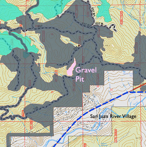
Please note that I am in no way advocating for the development of this particular gravel pit. Or any particular gravel pit.
Another project on Jackson Mountain — in this case, an ongoing study that began in 2012 — is a ‘silviculture’ project, part of an international ‘Adaptive Silviculture for Climate Change’ program. Jackson Mountain is one of ten North American experimental sites where forestry experts are purposely controlling the blend of tree species and shrubs, with certain goals on mind. From the ASCC website:
Each trial is focused on understanding and evaluating management options designed to enable forests to respond to a changing climate. Site-specific treatments were developed according to local conditions and tailored to meet site-specific management objectives, while at the same time aligned under a common framework for answering questions about how different forest types will respond to future climate…
Silvicultural treatments span a wide array of approaches, including (but not limited to) thinning, regeneration harvests, planting, site preparation, pruning, and prescribed burning. These approaches make up the toolbox that foresters utilize in managing for landowner and society’s values, such as wildlife habitat, timber, water resources, recreation, and carbon sequestration, among many others…
Here’s a map of that project, from the Jackson Mountain StoryMap page.
Considering the typical lifespan of a pine tree in the normally-arid American Southwest — 300 to 600 years — I presume that no one now alive will live long enough to see the outcome of this study.