On Monday evening, I could tell my friend was fired up. He couldn’t believe the community might be considering a new and very large gravel pit that would make use of Piedra Road as its main transportation corridor. He described Piedra Road as one of the most scenic roads in the community, and as the gateway to many of our nature-based playgrounds.
My friend was angry. Couldn’t this disaster be averted?
This was not the first time I’d been contacted about the proposed gravel mining operation on the Dutton Ranch. Daily Post readers Pam and Michael Kostin also reached out, and sent a letter to the editor which you can read here.
The Archuleta County Planning Commission’s hearing for this proposed mine was originally scheduled for January 26, 2022, but was later rescheduled for Wednesday, February 23 at 6pm — with a proposed hearing in front of the Archuleta Board of County Commissioners on Tuesday, March 1 at 1:30pm.
Both are public hearings where the commissioners are required to consider public testimony on the proposal, and will presumably be held at the County Administration Building at 398 Lewis Street — although judging by apparent public interest, it might be wise for the Planning Commission and BOCC to each consider a larger venue.
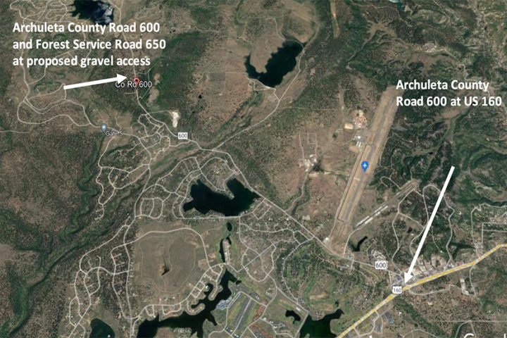
The mine is proposed for a site about 4 miles north of Highway 160, east of Piedra Road. A letter sent to County Development Director Pamela Flowers last October, from engineer Nathan Barton representing Cortez-based WASTELINE INC. reads like this:
SUBJECT: Submission of land use permit application, major sand and gravel, 112c construction materials project on Dutton Ranch
Dear Ms. Flowers:
As requested by the new owner of the Dutton Ranch, Silesia Properties LP (Silesia), represented by Mr. Rodney Urbanczyk, C&J Gravel Products Inc. has authorized WASTELINE to submit the application package, including the following items, for mining and producing (crushing and screening) sand and gravel roadbase and related construction materials on Oakbrush Hill, on Parcel No. 569906100003.
WASTELINE, Inc. is assisting both Silesia and C&J (see Attachment 1). We are requesting a County Land Use Permit for a Major Sand and Gravel project together with a Reclamation Permit from the Colorado Division of Reclamation Mining and Safety (DRMS) and other required permits to operate a 112c Regular Construction Materials operation at this same location, to produce construction materials for commercial and governmental use to meet demand in Archuleta and Hinsdale Counties. That is overlaying the area now for ranch production and includes additional land area, and a follow-up to this present ranch construction materials operation.
Hauling of construction material from the Oakbrush Hill Gravel operations will use the existing Ranch access to Piedra Road CR-600. Information on all matters of concern, as established in the Land Use Code, is provided in the DRMS application exhibits and other information enclosed…
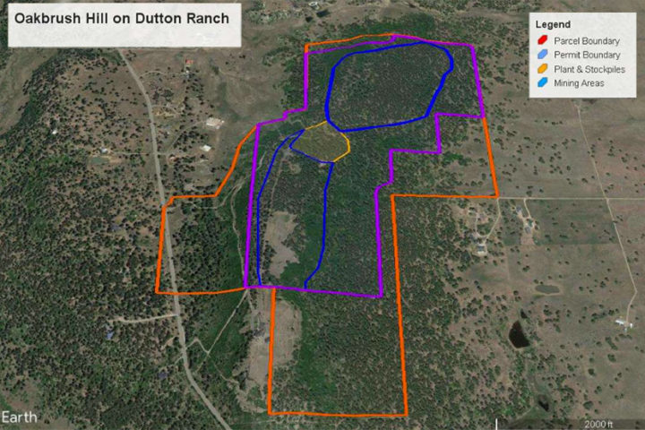
Here is a drawing of the proposed mine site as submitted to the County Planning Department.

We notice that colors in the ‘Legend’ do not match the outlines shown in the drawing. Daily Post readers are encouraged to use their imaginations.
All of the documents related to this gravel pit application are available online on the County website, here.
One of the documents indicates the potential size of the mining operation at 299 acres, or about 0.47 square miles. Apparently, the initial application mentioned the potential development of an asphalt plant and a concrete plant.
The initial response to the applicants, from Development Director Flowers, includes these comments:
After reviewing the traffic Impact Assessment from Wasteline, Inc. dated Oct 20, 2021, the proposed gravel pit would impact our road systems. Per the Archuleta County Road and Bridge Standards, Section 27.0.6.1, “New development shall be required to mitigate its proportionate share of impacts of the proposed activity on the County’s road system”…
For Air Quality Control, Archuleta County Engineering Department requires that the Applicant apply Magnesium Chloride the access road to mitigate the dust to the surrounded neighborhood…
G. Table 3: Uses by Zoning District in the Regulations does not allow asphalt or concrete batch plants in Agricultural Ranching (AR) zoning district. The narrative indicates the possibility of adding asphalt or concrete batch plants to the site in the future. Such an application could not be considered…
The application also includes a 54-page ‘Traffic Impact Study’ by Pagosa-based Bechtolt Engineering. The executive summary reads like this:
Bechtolt Engineering completed the Oakbrush Hill Gravel Development (development) Traffic Impact Study. The development is located at approximately mile point 3.8 on Archuleta County Road 600 (Piedra Road). The purpose of this study was to evaluate traffic impacts to the intersection of US 160/CR 600 based on a proposed development. This study was prepared in accordance with the State of Colorado’s Highway Access Code and existing conditions exceeds the requirements outlined in the code.
Traffic counts were conducted at the intersection of US 160 and CR 600. This data, also known as the background traffic, (existing 2021 traffic counts), was used as the base conditions. From there an analysis was conducted with the projected counts for the year 2041 and was calculated using a 22% growth rate. From there, the traffic generated from the development was added to both the base data (2021) as well as the projected counts (2041). This increase in traffic from the development reveals less than 7% increase to existing traffic and projected traffic.

In addition, we conducted a safety check to see if the design of the intersection meets or exceeds CDOT standards. The analysis conducted indicates that the existing roadway network is sufficient to provide for safe access with satisfactory operation for the development and continued acceptable operation of SH 160/CR 600.
The Bechtolt study concluded that the development can be implemented, and the highway system will continue to operate at “an acceptable Level of Service”.
