
This story was published in the Spring 2024 issue of ‘Headwaters’ magazine, a publication of Water Education Colorado. See the full contents here. We are sharing it in two parts.
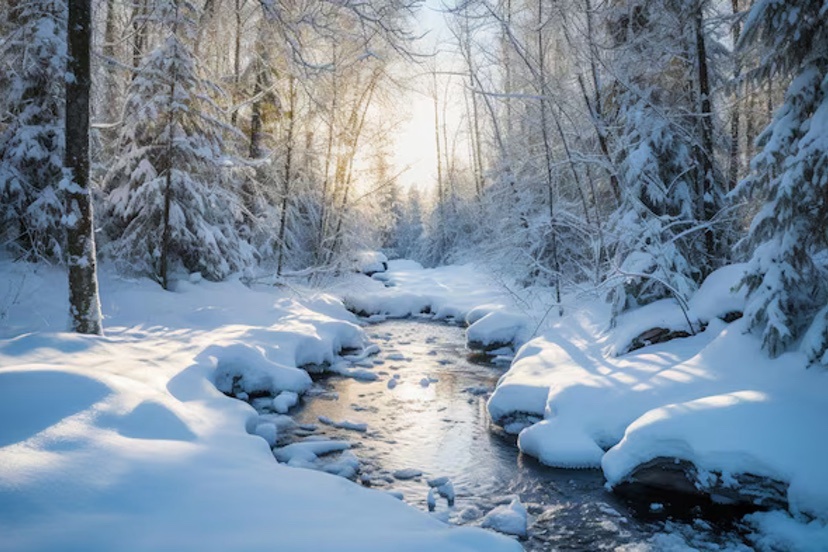
Ranchers in Colorado’s Yampa River Valley traditionally measured the severity of winters by snow accumulation on their stock fences. Plentiful accumulation put the snow at the top wire, making it a three-wire winter.
Four wires have become the norm on stock fences. No matter. By early March 2023, those wires at the foot of Rabbit Ears Pass were covered too. The Yampa Valley was sublimely white. It was a winter like the old days.
As expected, runoff was big and thrashing. Creeks tumbling through Steamboat Springs in May spilled over their banks. Downstream 75 miles, the Yampa River at Maybell peaked on May 18 at 16,500 cubic feet per second, more than 200% the average peak streamflow at that gauging station.
What happened afterward was very different. By July, the Yampa’s meager flows in Steamboat so concerned water managers that they nearly closed the warming river to recreationists in order to protect fish.
That big snowpack that resulted in head-high snowbanks along the streets in Steamboat? It produced a big runoff. But thievery had also occurred. Who, or what, absconded with the water? And how?
This mystery was not entirely new. April 1 snow depth in the Yampa and most of Colorado’s river basins has rarely correlated perfectly with runoff. Whether spring weather turns wetter and cooler, or hotter and drier, can alter the runoff dynamics.
“There is always that component of what the temperature and precipitation regimes are from April 1 through July,” says Karl Wetlaufer, a hydrologist and assistant supervisor at the Natural Resource Conservation Service, the federal agency that delivers the longest-running and most-used runoff forecasts. “They really drive a lot of what those forecast errors end up being.”
Then, too, the traditional methods for measuring snowpack have fallen short. Data from snow telemetry (SNOTEL) sites, is collected automatically from stations across Colorado. But those stations are relatively few compared to the complex geography. One station provides insights about one station, not a whole hillside or mountain. They provide an index.
A climate that has turned warmer and some say weirder during the last 10 to 20 years has some water managers wanting new tools. Whether in the San Luis Valley or the Yampa River Valley, what lies on the ground on April 1 remains the best predictor of river flows come July, August and September.
Water managers, from ranchers and farmers to reservoir operators and city staff, though, want improved models and data that more completely reveal the complexity of what is happening. They want to better understand why a huge snowpack can, by July and August, be such a dud.
What’s up with soil cracks and a changing climate?
Patrick Stanko, at his ranch four miles downstream from Steamboat Springs, has been puzzling over changes since he was a boy in the 1970s and 1980s. Summers have become hotter, winters less cold. Snow is gone sooner.
“The big snow banks of winter just disappear,” says Stanko. Water disappearing into the atmosphere is not a new process. But higher temperatures exacerbate it, whether that loss is to sublimation, where snow transforms directly into a gas, or evaporation, where snow melts and that water enters the atmosphere as a gas.
Milk Creek, which flows through the ranch that has been in his family since 1909, had become intermittent in its flows. Late-season grasses that his 100 head of cattle graze have become sparser with lessening summer rains.
Most striking are cracks in the ground that Stanko has noticed in recent years. He believes they have something to do with the shifted summer dynamics — dynamics that have implications into the next year’s runoff.
“We don’t get the rains that we used to get,” he says. “You used to be able to set your clock by the monsoon that would come.”
Haying in the Yampa River and other high country locations traditionally began in July or early August. Rain storms arrived almost simultaneously. If the rain forced ranchers to leave the grasses to dry, it was also helpful. Stanko says hay is best with 10% to 14% moisture content. Now, the timothy hay, brome grass and dryland alfalfa he grows on his 600 acres is often too dry after being cooked by hot winds.
Drying soils in fall have implications for spring runoff—the soils want their share of water first. That could bite into the total runoff, particularly in dry winters. Rainstorms in September have the reverse effect.
The 2024 Climate Change in Colorado report confirms many of Stanko’s observed changes. For example, summer precipitation has decreased 20% across northwest Colorado in the 21st century as compared to 1951-2000. Models suggest drier summers may become the norm — even with increased winter precipitation.
And warming has made the atmosphere thirstier. Evaporative demand is another name for this thirst. Warm air can hold more moisture than cool air. If nothing else changes, warmer temperatures increase evaporative demand.
The Climate Change in Colorado report, which was commissioned by the Colorado Water Conservation Board, cites a measure of evaporative demand called potential evapotranspiration (PET). It refers to the amount of water that would be evaporated or sublimated from the snow, soil, crops, and ecosystem if sufficient water was available. Between 1980 and 2022, PET increased 5% during Colorado’s growing season. When the ground holds less moisture, more of the sun’s energy heats the land’s surface and the atmosphere above it instead of evaporating moisture. This drives faster warming and lowers humidity.
Since 2000, streamflow across Colorado’s major river basins has been 2% to 19% less compared to the half-century before. Modeling studies have attributed up to half the declines to warming temperatures. And with declining streamflows, the need to make the most of available streamflows is heightened.
San Luis Valley and improved runoff forecasting
The story of dry conditions and low streamflows echoes 250 miles to the south in the San Luis Valley. There, water appropriation dates are older, elevations a little higher, and mid-summer temperatures a trifle toastier. Fifteen of the 20 hottest daily maximum temperatures recorded in Alamosa, including several in 2023, have occurred in the 21st century.
Snowfall in the San Juan Mountains largely determines how much alfalfa Cleave Simpson can grow on his farm south of Alamosa. The farm has water rights from 1879, but that isn’t senior enough to ensure reliable water deliveries, says Simpson, who is a Colorado state senator in addition to being a farmer and general manager of the Rio Grande Water Conservation District. State officials make adjustments to the water that can be diverted. “They do that every day,” says Simpson. “All in an effort to deliver to the state line as close as is possible the amount that we’re required to deliver.”
The Rio Grande Compact specifies how much water Colorado must deliver to downstream states. Depending on the year’s flows, Colorado sends between 35% and 70% of the Rio Grande’s water downstream. To ensure those deliveries, water managers must carefully calibrate flows they expect against demand from irrigators. Like those on the Yampa, water managers have wanted new ways of forecasting flows. “Because the old ways just aren’t working that well,” explains Craig Cotten, Colorado’s Division 3 water engineer, who leads administration in the Rio Grande Basin.
The old ways use primarily snow telemetry data, better known as SNOTEL data, which is automatically collected from stations across the state. That data is used to project flows using what Cotten describes as a “fairly simple regression analysis.” In other words, if X amount of snow in the past produced Y amount of water, then the same formula should hold today. But in the early 2000s, Cotten began to see that in some years, streamflow forecasts were not as accurate as he would have liked, he says.
What changed? Bark beetle infestations, by stripping trees of needles and exposing more snow to sunlight, altered runoff. So did wildfires, which in 2013 scarred 113,000 acres in Rio Grande headwaters areas. “That changed the dynamics of the forest system and how it related to the snowpack melting and running into the streams,” says Cotten, a 33-year veteran with Colorado’s Division of Water Resources. Dust-on-snow events work the same way. Dust blown from distant deserts accumulates on snow, drastically reducing the albedo, or reflectivity. The warmed snow melts more rapidly.
Overall flows have trended down. Flows on the Rio Grande at a gauging station near Del Norte, upstream from most diversions, averaged 8% less from 2000 through 2022 than during the preceding 50 years.
Snowpack in the Rio Grande’s headwaters in the San Juan Mountains was above average in 2019 and again in 2023, Cotten points out. But late-summer seasonal flows were below average. “Even in a good year, our farms and ranches struggle in the late season because we have below-average streamflow at that time.” And always, there’s the need to meet compact obligations, a task that Cotten says has become harder because of tightening water supplies.
Allen Best publishes the e-journal Big Pivots, which chronicles the energy transition in Colorado and beyond.