
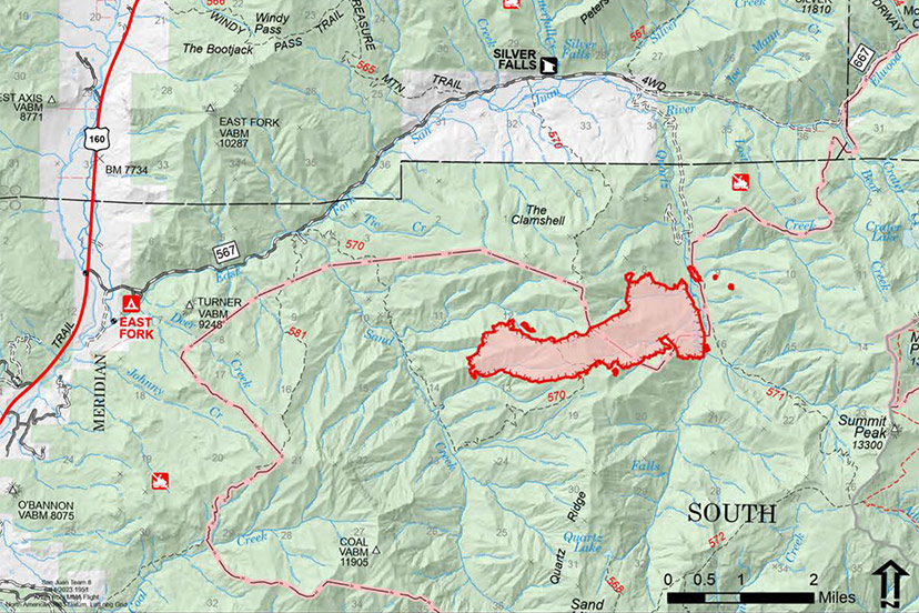
MAP: Quartz Ridge Fire
Quartz Ridge Fire
Fire start date: August 5, 2023
Cause: Lightning
Location: 13 miles Northeast of Pagosa Springs, Colorado
Incident Commander: Jay Kurth
Management Team: NIMO Team 1
Management: Suppression
Fire size (Tuesday morning): 1,440 acres
Containment: 0%
Personnel: 111
There are no current evacuations. Local residents should follow incident information for updates.
Firefighter and Public safety are the highest priority. Protect private lands within East Fork San Juan River drainage, natural resources, cultural and historic sites, recreation assets, and critical infrastructure including powerlines and gas utility lines.
Cloudy weather and rainstorms prohibited a Multi-Mission Aircraft flight to obtain updated acreage for the Quartz Ridge wildfire. Yesterday’s scattered thunderstorms and cloudy weather meant no increase in fire activity and firefighters did not smell or see any smoke from this wildfire. The three spot fires on the northeast side of Quartz Creek are diminished and the fire’s east side is holding at Quartz Creek.
The wildfire is burning in steep terrain in the South San Juan Wilderness. Indirect suppression tactics are the safest approach since significant (almost 90%) tree mortality exists which creates a potential for burning and falling trees. These hazardous conditions also limit access to crews from engaging in the spot fires that are now established on the east side of Quartz Creek.
Monday:
Continued to evaluate terrain and potential areas for containment outside of wilderness boundaries and scout for strategic areas for control.
Tuesday:
Continue with suppression tactic reviews, with the objective of keeping the fire south of East Fork Trail. Continue to improve the contingency line on the East Fork Road to the north and east of the fire. A module of firefighters will watch for spots from lookout locations. Continue to build structure protection plans both logistically and operationally. Crews will begin to use mechanized equipment along Forest Service Roads 631 and 643 to improve proposed strategic control lines. A chipper will be ordered to assist with removed trees and fuel.
Bear Creek / Mosca Fires
Bear Creek Fire start date: August 1, 2023
Mosca Fire start date: August 7, 2023
Location: 23 miles Northwest of Pagosa Springs, Colorado
Cause: Lightning
Incident Commander: Jay Kurth
Management Team: NIMO Team 1
Management: Suppression
Fire size (Tuesday morning): Bear Creek – 408 acres; Mosca – 7 acres
Containment: 0%
Personnel: 98
Weminuche Valley is under pre-evacuation notice. Local residents should follow incident information and updates.
Bear Creek Wildfire: Firefighters have been unable to directly engage the fire due to the steep remote terrain and heavy fuel loading of dead standing and down trees. The potential for spread remains in Bear Creek towards the Little Sand and Shaw Creek trails.
Mosca Wildfire: This wildfire is burning slowly in a remote area northwest of Bear Creek near Slide Mountain in steep terrain.
Firefighter and Public safety are the highest priority. Protect private lands within the Weminuche Creek drainages, natural resources, cultural and historic sites, recreation assets and critical infrastructure including powerlines and gas utility lines.
Cloudy weather and rainstorms prohibited a Multi-Mission Aircraft flight to obtain updated acreage for the Bear Creek and Mosca wildfires. Yesterday’s scattered thunderstorms and cloudy weather meant no increase in fire activity and very little smoke.
Monday:
Fire managers continued to use two masticators on the Mosca Road to the south of the fire to reduce fuels and to create a contingency line if that is needed. Crews in the Weminuche Valley area assessed risk level to private land/structures and developed and implemented structure protection plans. Local ground-fire resources continued to directly monitor fire growth and directional spread. These observations are critical to assess the probability of success with the current incident strategy. Pike hotshots were able to start a handline around the Mosca wildfire.
Tuesday: Continue fuels mitigation along the Mosca Road corridor with masticators. Utilize masticators to tie into a newly identified Forest Service Road. Begin prepping the Weminuche Trail to the wilderness boundary as a. contingency line. Operational supervisors will continue scouting indirect control opportunities to the south along the Mosca Road, connecting that into the Weminuche Valley.
Continue to collaboratively develop Management Action Points (MAP) with cooperators and stakeholders. MAPs are clearly specified incident conditions that, when reached, prompt a predefined fire management action or trigger the implementation of new strategies/tactics. Pike hotshots will work to complete the handline around the fire, monitor the fire and cut dead trees away from the fire perimeter.