
The map provided to the Pagosa Springs Town Council for their October 17 meeting proposed two different ways to extend Hermosa Street across a wild corner of our historic downtown, to make it more accessible to vehicles, and a lot less wild.
The government-sponsored development has been variously labeled as “Cottonhole Park” or as “Cotton Hole Park.”
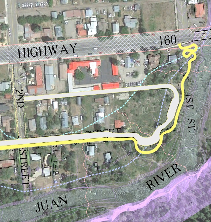
In the area of the proposed park, the provided map included a jumble of hard-to-decipher yellow and black lines drawn by local engineering firm Davis Engineering. Here’s a section of the provided map, showing Hermosa Street heading in from the west and coming to a dead end in the middle of the map, about where the “EE” of “STREET” is located :
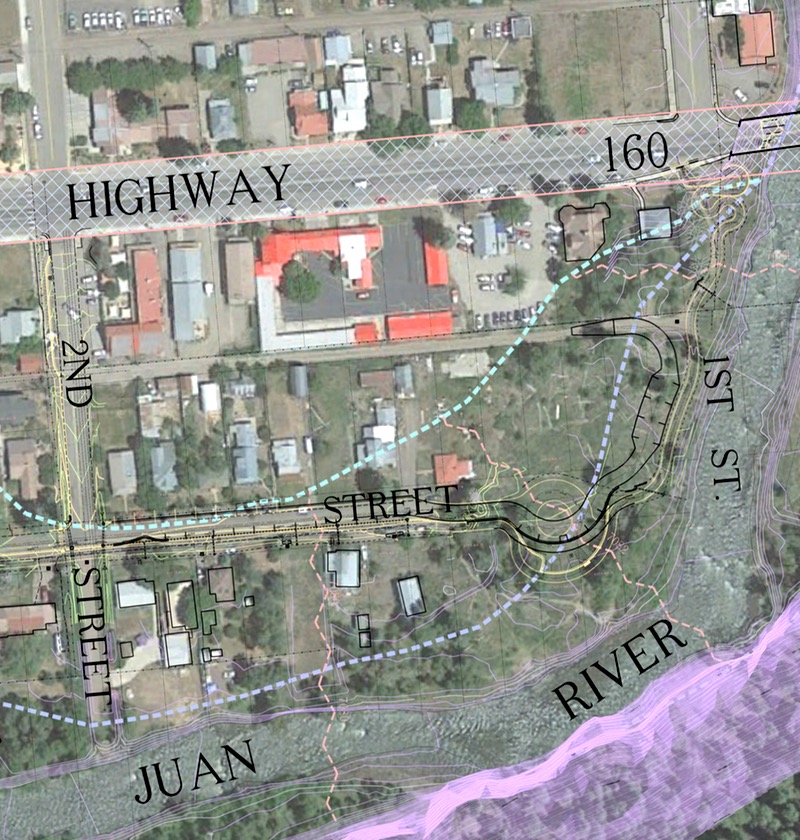
The dotted lavender-colored line shows the FEMA-defined ‘floodway’ where construction of buildings is prohibited, and the turquoise-colored dotted line shows the FEMA ‘floodplain’ where construction requires special consideration. The homes and businesses north of the ‘floodplain’ are considered safe, even in a 500-year flood event. The purple mass at the bottom indicates a steeply sloping shale hillside.
The trouble all started a couple of years ago, when the Town began getting serious about extending the River Walk Trail from Town Park — at the west end of Hermosa Street — to the First Street Bridge near the far east end of our historic downtown.
The map displayed above does not show the River Walk Trail between Town Park and South 2nd Street, but rest assured that it is proposed for along the south side of Hermosa Street as a 10-foot-wide sidewalk. Some readers might wonder why a rural town like Pagosa Springs would build a sidewalk as wide as the sidewalks in downtown Manhattan, to accommodate pedestrian traffic between Town Park and Cotton Hole Park. The reason is simple and complicated at the same time.
The Town applied for and was awarded a $400,000 grant from Colorado Parks & Wildlife for this trail extension, and the state trails people love to see trails that can accommodate both pedestrian and bicycle traffic. The state believes that bicyclists need a ten-foot-wide concrete trail in order to safely pass pedestrians, and because the federal government apparently has gobs of money to spend on transportation alternatives — and actually wants state and local governments to spend the money, as soon as it can possibly be spent — there was $400,000 available for a ten-foot-wide concrete sidewalk along Hermosa Street, continuing through Cotton Hole Park and terminating with ADA-accessible switchbacks at the 1st Street Bridge. The switchbacks are enormously expensive but are required because of the federal money involved, to permit people in wheelchairs to use the trail without undue effort.
On the David Engineering map, the River Walk Trail extension can be highlighted like this… with Cotton Hole swimming hole roughly indicated by a blue blob:
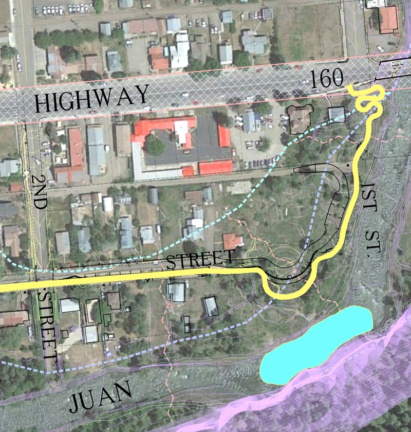
As we see in the above map, the 10-foot-wide River Walk Trail would take up about one-third of the Hermosa Street roadway, leaving about 20 feet of width for vehicle traffic.
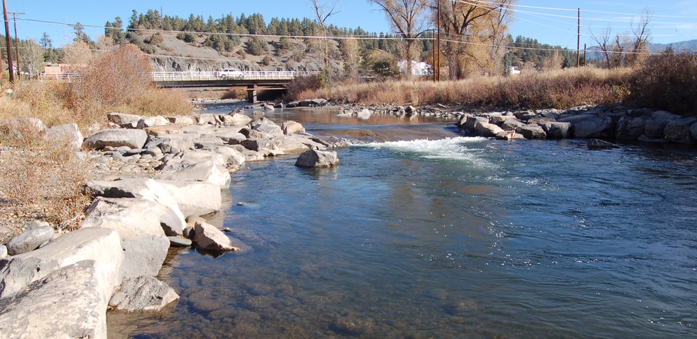
Here’s a photo of the Hermosa Street dead end, as it appears in 2019. The current dirt path to Cotton’s Hole heads straight through the cottonwood trees in the center of the photo.
A vehicle that has dropped off happy children headed for Cotton Hole can feasibly make a u-turn here. But once a 10-foot-wide concrete trail has been built on the right side of this picture, a vehicle will need to access a private driveway in order to turn around. Which is not something anyone wants.

One of the key discussion points at the October 17 Council meeting concerned a proposal by the Town Staff and Davis Engineering to extend Hermosa Street past the existing dead end, and to create either a cul-de-sac near Cotton Hole, or street that winds through the park and connects to the Hermosa Street Alley.
Here’s the cul-de-sac proposal, highlighted:
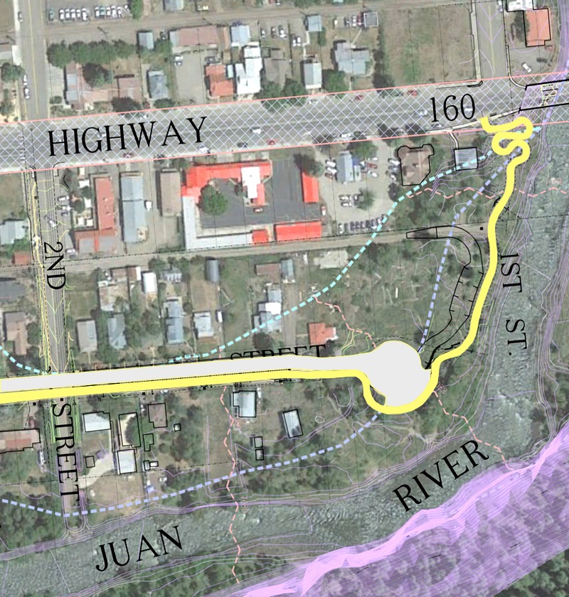
The cul-de-sac, as proposed by Davis Engineering, would include a parking area on the Cotton Hole side of the roundabout. As we notice, this accommodation for vehicles consumes a sizable portion of what was not a very large park to begin with, and turns it into asphalt pavement.
Here’s a photo of the area were this potential cul-de-sac would be located.

In other words, in an effort to preserve a quiet, rustic swimming hole for community use, the Town might end up creating a parking lot for RVs and camper trucks, to accommodate some of our tourists, or even some of our local workers who are currently unable to find affordable housing, and dramatically change the character of this (currently rustic) park.
Not everyone on the Council was excited about this possibility.
There was an second option presented — a street that would run through the middle of the park and then head north to connect with the Hermosa Alley — a narrow, gravel alley that the neighborhood uses to access their back yards. This new street would also include one parking area near the old swimming hole and another parking area near the new ‘whitewater’ feature located near the east end of the Hermosa alley. With enough tax money thrown at it, it might look something like this:
We shared a couple of photos of the new whitewater feature yesterday in Part One. Here’s another look at that recreational feature, during low water such as we typically experience in October:

And here’s another phot0 of the shale hillside that drops down into the old swimming hole.

In my experience, engineers and public works directors tend to view the world as infrastructure challenges that require solutions. Sometimes these solutions ignore the impacts on long-time residents who’ve grown accustomed to dead-end streets and unspoiled beaches. Thankfully, our Town Council is composed of non-engineers, so we sometimes hear a different perspective.
Here’s Council member Mat deGraaf, addressing the two options that had thus far been placed before the Council.
“With the second option, you’re essentially taking an alley and making it into a street, and with that comes a whole host of responsibilities, that — until right now — I didn’t put two and two together on. So, I’d like to hear what the residents think about how this will impact to their neighborhood. People who live on cul-de-sacs or on dead-end streets generally seek those areas out, because of what they are. They’re less busy, they’re safer for kids; there are reasons why individuals like to live on cul-de-sacs. Whatever we do here, we’re going to change the neighborhood — pretty drastically. And I’d like to hear what the residents have to say.”
Council member David Schanzenbaker asked if these two options were the only suggestions for dealing with Cotton Hole Park vehicle traffic.
“I dislike both of these ideas…”