Following an overview of the Division of Water Resources by Water Commissioner Joe Crabb, and a summary of the new Drought Management Plan by Pagosa Area Water and Sanitation District (PAWSD) Manager Justin Ramsey — during a Wednesday, March 31 Zoom presentation hosted by Mountain Studies Institute — we had a chance to hear about the work being done by the Upper San Juan Water Enhancement Partnership — also know as the ‘WEP’. The WEP’s work, funded mainly through grants from Colorado state agencies, will ultimately result in a ‘Stream Management Plan’.
As I understand it, the general intention behind SMPs (Stream Management Plans) is to get all the water users within a particular drainage basin to sit around a table — perhaps, a Zoom table? — and work out an equitable plan for the future of the community’s water that everyone can feel equally unhappy about. Or, looked at from another perspective, equally happy with.
Historically, in Archuleta County, nearly all of the water infrastructure consisted of a system of gravity-fed agricultural ditches and diversion gates that directed water to the various large and small ranches in the area. Another part of the water picture involved piping water from the San Juan River to downtown Pagosa Springs. Back in those days, water in Archuleta County was viewed as a boundless resource that required considerable physical labor to direct it here and there, as needed for ranching operations and for drinking water for town residents.
Later, starting in the 1970s, the PAWSD district was formed to service a planned 21-square-mile suburban development west of downtown, now known as Pagosa Lakes. In 1992, PAWSD took over the operations of the downtown water system, and also the operations of the Archuleta Water Company, which served areas outside of Pagosa Lakes and downtown. That created a water district with about 300 miles of water mains… some new, some old.
In terms of square miles, most of Archuleta County is not served by any municipal water system. The outlying areas are, however, served by ditches.
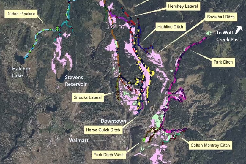
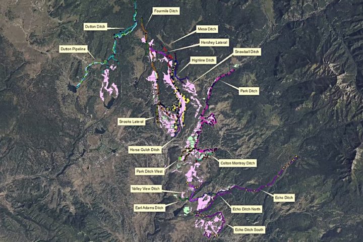
Here’s a map shared by San Juan Conservation District Manager Cynthia Purcell on Wednesday.
The San Juan Conservation District is not to be confused with the San Juan Water Conservancy District. Two different animals.
The San Juan Conservation District is federally funded by the US Department of Agriculture, and as such, works primarily with ranchers and farmers in the area. That is to say, the San Juan Conservation District concerns itself with the folks who make use of about 94% of the water diverted in Archuleta County.
The San Juan Water Conservancy District (SJWCD) is funded by your local property taxes, and has, in the past, focused on the development of new water reservoirs that might serve District residents — the urban and suburban residents who use about 5% of the water diverted in Archuleta County. Recently, SJWCD has been promoting a future reservoir in the Dry Gulch Valley, on land jointly owned by PAWSD and SJWCD. Even more recently, SJWCD has expanded its focus to consider other ways of ensuring sufficient municipal water supplies, and has documented that expanded focus in its new Strategic Plan.
Note: I currently serve on the San Juan Water Conservancy District board of directors, but this editorial reflects only my personal perspectives and opinions, and not necessarily the perspectives or opinions of anyone else on the SJWCD Board. SJWCD has been helping to fund the WEP’s research.
The map shared by Ms. Purcell shows a couple of things. It shows some of the larger ditches that direct water to local ranches and farms — and it shows the types of irrigation systems that serve those ranches and farms.
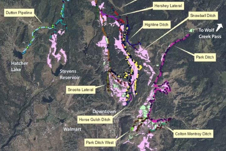
Here is a slight close-up of Ms. Purcell’s map, showing the area surrounding downtown Pagosa Springs, with some identifying words added. Hatcher Lake. Walmart. Downtown. Wolf Creek Pass.
In the top left corner, we can see the Dutton Ditch, which feeds water from Four Mile Creek to various ranches, and to the Dutton Pipeline leading to Hatcher Lake, from whence a PAWSD treatment plant dispatches drinking water to residential and commercial users in the Pagosa Lakes Area. Enclosed in a pipe, the Dutton Pipeline helps conserve water flowing into Hatcher Lake.
Other significant ditches are the Park Ditch, which delivers San Juan River water to agricultural users on the east side of Highways 160 and 84, and the Snowball Ditch, which serves users along Snowball Road.
The ‘pink’ ranches on the map basically use a 19th century irrigation method — the method Ms. Purcell referred to as “ditch irrigation”. The ‘green’ ranches on the map use a somewhat more efficient irrigation method known as “gated pipe irrigation”. We’ll be looking more closely at irrigation types — and their implications — in Part Three.
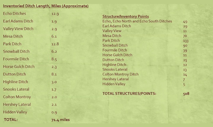
As part of the ‘Stream Management Plan’ process, Ms. Purcell and a team of researchers conducted an inventory of area ditches and diversion structures last year, including photography and analysis, and created a spread sheet that will be shared, in the near future, with ditch company members… and sometime later perhaps, with the rest of us. The inventory involved walking about 71 miles of ditches, and photographing and analyzing about 500 “structures and points” along those 71 miles.
Most of the Archuleta County ranches that are served by ditch systems date back to the late 1800s and early 1900s. As such, the water rights belonging to those ranches are ‘senior water rights’ and have priority over most of the municipal water rights owned by PAWSD and SJWCD. This explains why, for example, the Dutton Pipeline, leading from the Dutton Ditch to Hatcher Lake, typically sits empty from mid-June until mid-September, while the surrounding Dutton Ditch ranches may be able to divert all summer long.
Colorado has a lot of laws around water use, and water conservation. What Colorado does not have, at the moment, is a requirement that agricultural users — the folks responsible for 90% of the state’s water diversions — must use the most efficient irrigation methods available.
More about that little controversy in the next installment.


