
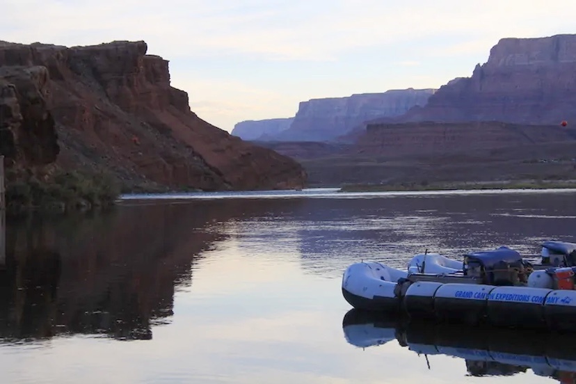
Photo: Lee Ferry, located in Arizona but a few miles downstream from Glen Canyon Dam, is the formal dividing point between the upper-basin states and lower-basin states in the Colordo River. It’s also the put-in location for boaters rafting or kayaking the Grand Canyon. Photo by Allen Best.
Andy Mueller, general manager of the Colorado River District, has used the district’s annual seminar in Grand Junction in years past to warn of a worsening situation in the Colorado River Basin. Two years ago, for example, he warned that flows were already well below the 20th century averages. Might those flows of 13.5 to 14 million acre feet further decline to 9.5 million acre-feet in decades ahead?
Even relatively healthy snowfalls don’t necessarily produce robust volumes of runoff. For example, snow during the winter of 2023-24 was good but runoff just 84% of average.
“A new different” is how Dave Kanzer, the River District’s director for science and interstate matters, described the runoff numbers.
“We are just kind of treading water, and where we are next year could be similar to where we are this year — unless something changes,” he added during the district’s seminar in Grand Junction. “There’s a lot of uncertainty.”
Warming temperatures most likely will produce continued declines in river flows. That was a key takeaway of the presentation by Russ Schumacher, the state climatologist. He’s a careful scientist, clear to differentiate what is known from that which is not. Much of what he said was not particularly new. Some of the conclusions he offered were little changed from those of a decade ago – but with one key difference. Another decade of data has been compiled to support those conclusions.
Seven of Colorado’s nine warmest years have occurred since 2012. The rise can be seen most clearly in summer and fall records. This past summer was part of that trend. It was the sixth hottest summer in Colorado’s recorded history going back to the late 1800s.
Some places were hotter than others, though. In Grand Junction, gages at Walker Airfield recorded the hottest June-August period ever, an average of more than 80 degrees. That’s the average temperature 24/7, day and night.
Precipitation? No clear trend has emerged. Levels vary greatly from year to year.
Integration of temperature and precipitation records tell a more complex and concerning story. Rising temperatures have produced earlier runoff. The warmth also exacerbates evapotranspiration, which is also called evaporative demand. The warmer it is, the more surface air draws water from the plants and dries out the soils.
“The timing shift, even if the peak doesn’t change all that much – the timing is quite important,” said Schumacher. Colorado River flows at Dotsero, near Glenwood Canyon, have already declined 25% during late summer.
Schumacher and other scientists describe predictions with various degrees of confidence. There is, he said, high confidence of a future warming atmosphere that to an even greater degree reduces runoff no matter how much snow falls in winter. We can be sure of temperatures rising between one and four degrees F by mid-century, he said.
Unless Colorado gets far more snow and rain, the Colorado River will decline further.
Future warming depends upon how rapidly greenhouse gas emissions rise globally. In mid-October, they were at 418 parts per million high on the slopes of Hawaii’s Mauna Loa. They were 315 when the first measurements were taken there in 1958 and roughly 280 at the start of the industrial era.
All of Schumacher’s presentation is valuable, as is his slide deck. Both can be found on the River District website under the annual seminar heading.
And that returns us to the Colorado River Compact, the foundation for deciding who gets what and where in the basin — and who doesn’t.
In 1922, when the Colorado River Compact was drawn up at a lodge near Santa Fe, the Colorado River had been producing uncommonly robust flows. In their 2019 book, “Science Be Dammed,” Fleck and Eric Kuhn, the former general manager of the River District, explained that ample evidence even in 1922 existed of drier times just decades before. Later evidence documented lesser flows in the centuries and millennia before.
Not only were flows in the Colorado River during the 20th century much less than was assumed by the compact, the document failed altogether to acknowledge water rights for Ute, Navajo and 28 other Native America tribes in the basin who were to get water as would be necessary to sustain agricultural ways of life. Just how much had not been determined, although it’s now estimated at 20% of the river’s total flow. Some claims still have not been adjudicated.
Mueller called it a “flawed document” produced by a “flawed process” that had “faulty hydrological assumptions” and did not include “major groups of people who reside in and own water rights in this basin.”
For its time, though, the compact was a grand bargain. Colorado’s Delph Carpenter was a key negotiator. He had realized that if diversions from the Colorado River were determined by the doctrine of prior appropriation, the bedrock for water law in Colorado and most other states, the upper-basin states would lose out because they would develop the Colorado River more slowly. Instead, the compact created an equitable apportionment, essentially a 50-50 split of the water between upper and lower-basin states.
It was the foundation for what is now called the Law of the River, by which is meant the many laws, court decrees and agreements concerning both surpluses and droughts.
Dams were built, diversion structures constructed – including, because of a law of Congress in 1968, the Central Arizona Project (which also resulted in dams on the Animas and Dolores rivers in Western Colorado). That 1968 legislation, the Colorado River Basin Project Act, recognized that the river would be short by as much as two million acre-feet, said Mueller.
And then the agreements of the 21st century have tried to acknowledge lesser flows. But they have also deferred the really hard questions. The harder questions, as Mueller suggested, may yet provoke the states to get out their legal swords.
Central to the dispute is how much water should the upper basin states be releasing from Lake Powell? This is the key clause in the compact: “The States of the Upper Division will not cause the flow of the river at Lee Ferry to be depleted below an aggregate of 75,000,000 acre-feet for any period of ten consecutive years …”
Flows from Colorado and other upper-division states have been about 86 million acre-feet over the last 10 years.
Lower-basin states say no, that’s not enough. They argue that the upper basin states need to accept cuts, too.
For now, there is no dispute that the upper basin states are meeting that obligation. But what if a string of years like those of 2002-2004 return? And what if the case ends up before the Supreme Court and that court ultimately rules against the upper basin?
This sets up the potential – Mueller characterized it as a certainty – for conflict, a court case that will have to go before the U.S. Supreme Court.
“I don’t believe we’re violating the compact today, and I don’t think we’re going to be violating the compact necessarily if the river drops, if our delivery below Glen Canyon drops,” he said. “What I can tell you is, we’re going to have litigation.”
Colorado, Mueller asserted, must put together rules for how it will handle shortages if the state must curtail it diversions in order to allow water to flow downstream. He called it a painful process but warned that the “future is not far away.”
The River District position is that the burden within Colorado cannot fall entirely on the Western Slope and its ag users. Programs designed to reduce compensation have been focused solely on the Western Slope and agriculture, says Lindsay DeFrates, deputy director of public relations.
“If we are looking to reduce water long term, we can’t put it on the backs of West Slope users,” she says. “It has to be a shared burden.”
Journalists insist that it’s Western Slope. People in the water community invariably say “West Slope.”
Allen Best publishes the e-journal Big Pivots, which chronicles the energy transition in Colorado and beyond.