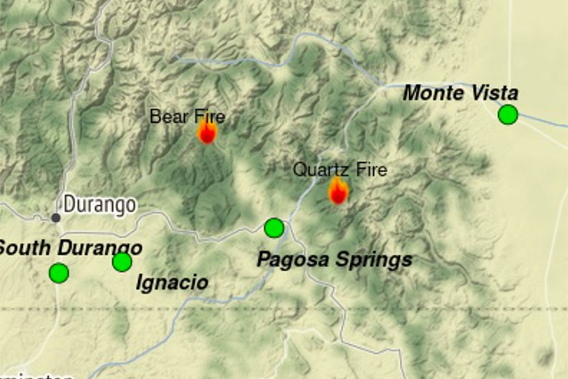
Bear Creek Fire
Bear Creek Fire start date: August 1, 2023
Mosca Fire start date: August 7, 2023
Location: 23 miles Northwest of Pagosa Springs, Colorado
Cause: Lightning
Incident Commander: Jay Kurth
Management Team: NIMO Team 1
Management: Suppression
Fire size today: Bear: 394 acres; Mosca: 7 acres
Containment: 0%
Personnel: 86
Evacuation Information: Weminuche Valley is under pre-evacuation notice. Local residents should follow incident information and updates.
Closures: Cloman Park in Pagosa Springs
Highest priority: Firefighter and Public safety. Protect private lands within the Weminuche Creek drainages, critical infrastructure including powerlines and gas utility lines, natural resources, cultural and historic sites, and recreation assets.
Wetting rains, cloudy weather and cooler temperatures assisted with slowing fire movement. The aspen stands to the east and south of the fire continued to slow fire growth, as they are less susceptible to fire spread. Firefighters have been unable to directly engage due to the dangerous loading of standing and down dead trees. While fire fighters are prepared for the fire to back down to the Weminuche Valley, significant fire growth is not expected today. The potential for spread remains in Bear Creek towards the Little Sand and Shaw Creek trails. Structure protection groups are in place and are assessing additional structures as well as monitoring the fire from the meadow.
The Mosca Fire grew slightly to 7 acres, burning in heavy down fuels and is headed toward a large aspen stand. The fire is burning in a remote area northwest of Bear Creek near Slide Mountain in difficult terrain.
Saturday: Fire managers continued to use two masticators on the Mosca Road to the south of the fire to reduce fuels and to create a contingency line if that is needed. Crews in the Weminuche Valley area assessed risk level to private land/structures and developed and implemented structure protection plans. Local ground-fire resources continued to directly monitor fire growth and directional spread. These observations are critical to assessing the probability of success of the current incident strategy being achieved.
Sunday: Continue fuels mitigation along the Mosca Road corridor with masticators. Operational supervisors will continue scouting indirect control opportunities to the south along the Mosca Road, connecting that into the Weminuche Valley. Continue to collaboratively develop Management Action Points (MAP) with cooperators and stakeholders. MAPs are clearly specified incident conditions that, when reached, prompt a predefined fire management action or trigger the implementation of new strategies/tactics. Pike hotshots will be flown into the Mosca fire to assess the fire and begin to cut an access trail.
Quartz Ridge Fire
Fire start date: August 5, 2023
Cause: Lightning
Location: 13 miles Northeast of Pagosa Springs, Colorado
Incident Commander: Jay Kurth
Management Team: NIMO Team 1
Management: Suppression
Fire size August 23: 1,374 acres
Containment: 0%
Personnel: 103
Evacuation Information: There are no current evacuations. Local residents should follow incident information for updates.
Closures:
Quartz Meadows Rd (NFSR#685)
Quartz Ridge Trail (NFST#570)
Quartz Creek Trail (NFST#571)
Highest priority: Firefighter and Public safety. Protect private lands within East Fork San Juan River drainage, critical infrastructure including powerlines and gas utility lines, natural resources, cultural and historic sites, and recreation assets.
Limited fire growth was east of the fire, with a new spot fire on the east side of Quartz Creek. Yesterday’s wetting rains, the cooler temperatures and higher humidity will slow the fire’s growth; however, fire behavior analysts anticipate the weather will only slow fire growth until warm weather returns. The influx of moisture also does not change the risk factors preventing firefighters from engaging the fire directly. The fire is burning in the South San Juan Wilderness in extremely steep terrain with standing and down dead trees; this elevates the risk to firefighters and aviators. These risk factors also exist in the Quartz Creek drainage, preventing crews from engaging the spot fires that are now established on the east side of the creek. Aviation assets may be used to support ground firefighters in this area, along with aerial supervision as needed.
Saturday: Continued to develop Management Action Points, which are clearly specified incident conditions that, when reached, prompt a predefined fire management action or trigger the implementation of new strategies/tactics. Due to muddy roads and moderate fire behavior, limited personnel were able to access the area.
Sunday: Continue with suppression tactic reviews, with the objective of keeping the fire south of E. Fork Trail. Identify additional values at risk toward Elwood Pass. Continue to scout viable control features and contingency lines, particularly on the East Fork Road to the north of the fire and to the east. Continue to build structure protection plans both logistically and operationally. Identify lookout locations to track fire progress.

