
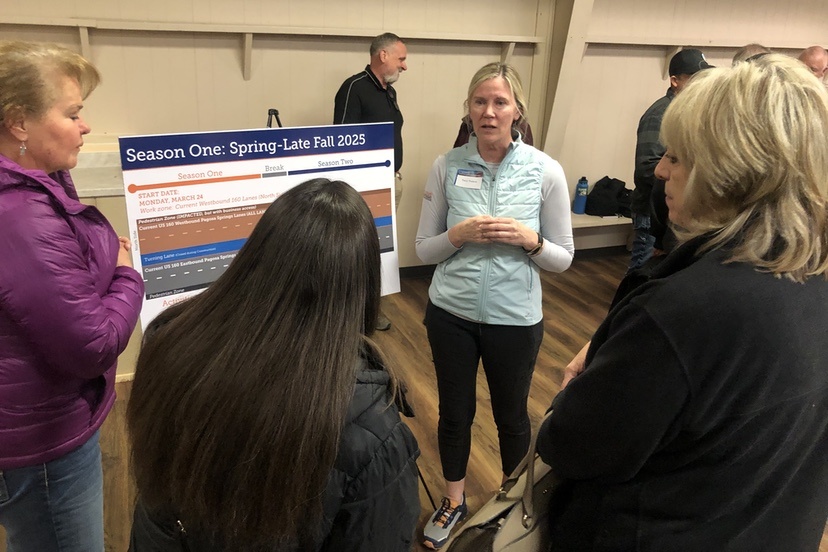
By my count, about 80 people showed up at the County Fairgrounds Extension Building on Monday evening for an ‘open house’ with representatives from the Colorado Department of Transportation, to discuss the biggest potential impact on downtown Pagosa Springs since the Adobe Building burned down in 2016.
That impact being CDOT’s planned reconstruction of U.S. Highway 160 as it runs through the historic business district.
Some older maps label the west half of this particular stretch of highway as ‘San Juan Street’… and the east half as ‘Pagosa Street’… and once upon a time, they were, indeed, ‘streets’.
But neither half has been a ‘street’ for many years now. For as long as I’ve lived here, it’s been a Highway.
The homes and businesses facing the highway, however, grew up when these were ‘streets’… used by pedestrians, horses, wagons, and eventually, automobiles… and still later, by semi trucks and RVs traveling the main east-west highway in southern Colorado.
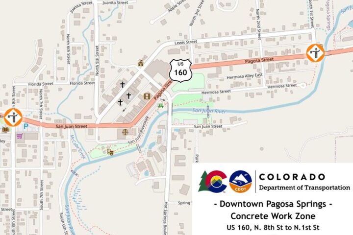
Apparently, the highway was not originally constructed to handle the number of large, heavy vehicles that now pass through Pagosa Springs, because it’s now going to get a rather complete rebuild between 8th Street and 1st Street.
Staring on March 24.
CDOT had previously announced a start date of March 17, but local business owners had urged a delay, until after Spring Break — an annual burst of economic activity here in Pagosa driven by winter sports enthusiasts from Texas and Oklahoma.
The CDOT staff — and the representative for the contractor, WW Clyde — seemed cautiously optimistic that the project can be completed by start of winter, 2026, allowing for a break during the 2025-2026 winter.
Of course, the project has already been delayed one week to accommodate downtown businesses and their Spring Break customers. Other delays will no doubt occur.
A couple of the display boards illustrated the plan for converting a sometimes-three-lanes-sometimes-four-lanes-sometimes five-lanes highway segment into a two-lane thoroughfare on the south side, and ripping up the north side. It would appear (from what I saw) that the completed project will be one lane in each direction, with a ‘turning lane’ in the middle, and with bike lanes and parking on each side. The new road surface will be concrete instead of asphalt, and brand new water and sewer lines will be installed underneath.
In a couple of spots, the center turning lane will disappear and a raised median will appear, to better accommodate pedestrian crossings mid-block.
People may wonder about the wisdom of replacing the four lanes currently striped between 4th Street and 8th Street, with two lanes and a turning lane (or median), but we can note that CDOT has already converted much of the highway through town to two-lanes-plus-turning-lane. This also reflects a change of philosophy at CDOT, giving priority to “slower traffic in urban areas” — for safety reasons — rather than focusing mainly on moving traffic faster and more efficiently.
Turns out, efficiency kills people.
The open house did not include a lecture or PowerPoint slideshow about the upcoming project, but rather, featured CDOT personnel posted at various stations, to answer our questions. And questions did indeed arise.
I live downtown myself, a couple of blocks from the highway, and the eight intersections that will be reconstructed are part of my daily travel patterns. And I recognized a number of the attendees at the open house as my residential and business neighbors. The residents are naturally interested in understanding how they will get out of downtown to do our activities and shopping in other parts of the county. The businesses are naturally interested in how their potential customers will get into downtown, and where they will park, since there will be no on-street parking allowed during the two construction seasons.
Really? Two years?
A couple of years ago, CDOT replaced the massive (and failing) McCabe Creek metal culverts, near the intersection of Highway 160 and S. 6th Street, with a new concrete culvert system that could better accommodate extreme weather flooding. (We’ve all notice the tendency by the media to warns us, constantly, about a promised increase in extreme weather events.) That project was scheduled to take two construction seasons, but bled into a third year.
Some of us expect the same thing to happen with this new project. Anyone who’s lived in Pagosa for any length of time is used to such delays. The question, in this case, is: how long can a downtown business hold out, if the project bleeds into year three?
One of the most active stations had on display a printed drawing of the entire project, stretching across several large plastic tables.
The printout brought home just how big this project will be.

The north side of the highway, schedule to be completed this year, was marked in orange, with most of the intersections marked in green and marked with the number “2”. When I asked what the “2” meant, I learned that the intersections were seen as a “second phase” of the 2025 work. The plan seems to be to always have an intersection accessible within a couple of blocks. This year, that will likely be a concern more for businesses and homes on the north side of downtown — since it’s the north side of the highway under construction this year. Next year, the south side of town will have to deal with more of the inconvenience.
Assuming the north side gets done this year.
In either case, a lot of the secondary roads and rural back roads, accessible from either side of the highway, will be seeing additional traffic, as the community figures out how to get from ‘here’ to ‘there’ without driving through the construction zone.