Some Daily Post readers may have enjoyed a recent op-ed by our editor, Bill Hudson: “How About Them Home Prices? Part Three”.
And some may have not enjoyed it.
Who am I to presume?
At any rate, his editorial made mention of a outdated book from 1981, The Nine Nations of North America by Joel Garreau, and it included the map, below, illustrating Mr. Garreau’s impression of the cultural and economic regions that tend to exist across North America, in defiance of obvious state boundaries.
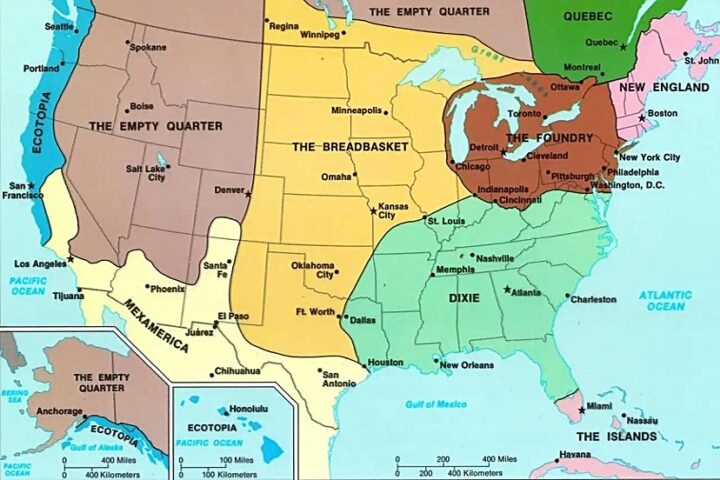
In Mr. Garreau’s opinion, Colorado had split its cultural loyalties between “The Breadbasket” to the east, “The Empty Quarter” to the west, and a bit of “MexAmerica” in the region around Pagosa Springs. After seeing this map, I suddenly began to notice the number of customers who speak Spanish at Walmart.
But in reality, this map was from 1981. Half a lifetime ago.
Or more than half, if you’re a cigarette smoker.
Some of us were not even out of high school in 1981. (I’m not counting the guys who dropped out in 10th grade and became truck drivers.)
A more recent book, American Nations: History of the Eleven Rival Regional Cultures of North America by Colin Woodard was published in 2011, subsequent to practically every Daily Post reader graduating from high school or learning to drive trucks. Mr. Woodard expanded on Mr. Garreau’s general idea — the idea that we might be one nation under God but we sure as hell have different ideas about what to eat for dinner. He also expanded the number of purported regions from nine to eleven, and added some background history on how we got this way.
In 2011, the map on the book’s cover looked like this:
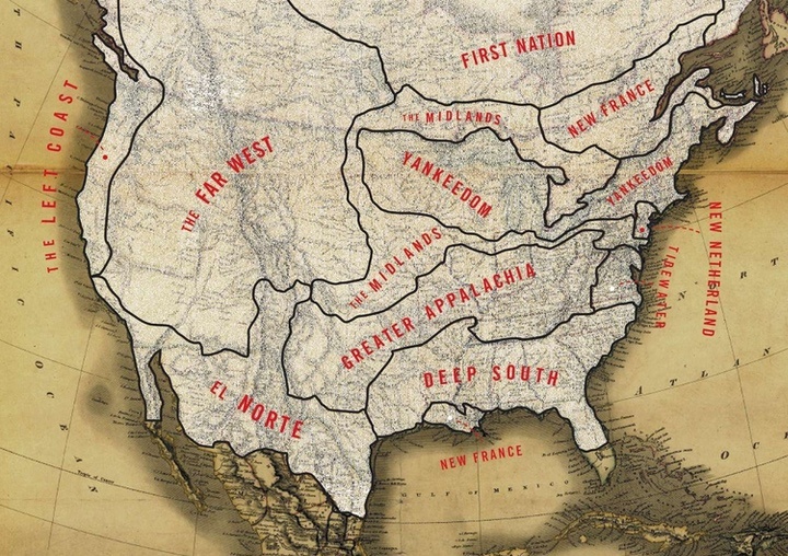
Mr. Woodard didn’t even bother to show the state boundaries, but Pagosa still looks (to me) like part of a Spanish-influenced culture, now named “El Norte”. (We might note that the southern tip of Florida is not one of the eleven nations — it’s part of the “Caribbean” — which could cause one to ask whether Donald Trump was actually an American citizen when he got elected. But don’t ask.)
Apparently, Mr. Woodard was just getting started on telling us how different we are from one another, because he’s been tracking and refining his ideas since 2011, and breaking down the U.S. according to Census and DNA data. This additional research has generated a new (and more colorful map) that shows 17 rival regional cultures. (With southern Florida restored to its rightful national affiliation. So see, you didn’t need to ask.)
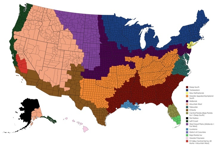
His latest maps are refined to the ‘county’ level, and although Colorado is still split up — now into four rival cultures — Archuleta County no longer appears to be part of “El Norte”. We’re now part of the “Mountain West” along with Utah, Nevada, Idaho and portions of several other states.
There is no way Utah should be in the same regional culture as the rest of us. In my humble opinion.
But many of us are aware of another recent map that divides up the U.S.
The map based on how states voted in the November election.
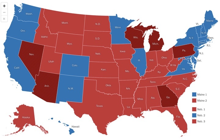
How in the world did we get here? Where Colorado is an island of blue, practically surrounded by a sea of red?
The state with the nation’s first openly gay Governor?
The highest percentage of EV sales in 2024 Q3? Passing up California and Washington?
Immigrants can get a real driver’s license?
Abortion is guaranteed in the Constitution?
Importing wolves?
I mean, like, actual meat-eating wolves?
I can think of only one explanation for this strange situation, in a state that — on other well-researched maps — is split up into three or four “rival regional cultures”.
Legalized marijuana.

