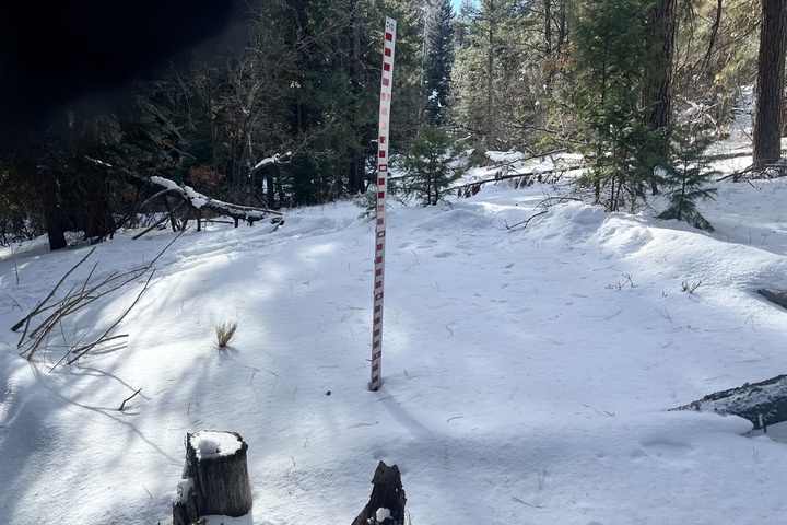
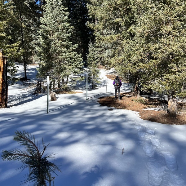
Photo: A trail camera captures the installation of a snowtography research site on Jackson Mountain in the fall of 2023.
By Alex Handloff
On a beautiful sunny winter day, five people trudge up Jackson Mountain to an undisclosed location. Sure, it’s for fun — how could it not be enjoyable — but they’re also on a scientific mission: to better understand snowfall in forested areas as part of a regional network.
“We enjoy snowshoeing and learning about the science of snowtography, it’s been a fun and informative experience,” says Bob Milford, resident of Pagosa Springs, President of Pagosa Area Trails Council and member of the San Juan Headwaters Forest Health Partnership.
Milford, along with other volunteers from the San Juan Outdoor Club, Steve Earle, Mike Cianciolo, Bill Milner, Joe Tedder, Jeff Reichel, and Rob Barlow, will take the trek up to the site twice a month over the winter months. Today, they’re here as part of a training on how to capture and record monitoring data. It takes approximately one hour to reach the site, tucked away behind Ponderosa pine and blue spruce where there’s a line of sticks submerged in the ground, covered by the year’s sparse early season snowfall. What may seem rudimentary at first glance is in fact a robust monitoring system, putting the proverbial microscope to snow in forested areas.
“Snowtography is an approachable method to quantify how forest structure and forest management impacts snow accumulation, retention, and subsequent water yields,” explains Dr. Kurzweil, the Hydrologist and Associate Director of the Water Program at Mountain Studies Institute (MSI). “We utilize snow stakes and game cameras to get snow depth daily, we then build regressions with the bi-monthly snow water equivalent data collected to get daily snow water equivalent. We also have soil moisture sensors at multiple depths to understand water availability for vegetation or aquifer recharge.”
Dr. Kurzweil and Lenka Doskocil, Water Program Research Associate at MSI, are leading the training for the local Pagosa crew on how to gather data, preserve the integrity of the site, and stay safe. There are other sites in the San Juan Mountain — five in total — that are being managed by Mountain Studies Institute, each with a team of dedicated data gatherers.
The Jackson Mountain site was spearheaded by the San Juan Headwaters Forest Health Partnership with the help of numerous collaborative partners. The location is of particular interest for Headwaters and the Pagosa Springs community given that it’s a hotbed of sorts for research, community interests like recreation, forest restoration projects, and elk migration.
In October, Doskocil led a group to Jackson Mountain to install the snowtography site that has just begun capturing vital information that can eventually help natural resource managers plan for future conditions.
“These sites are designed to be low tech, but you don’t realize how much work it takes to get them installed,” says Doskocil. “There’s always a bit of a question if what makes sense in the summer during installation will still work when there’s snow on the ground and you’re sending people up and down trees in a ladder. It’s really rewarding to see things running relatively smoothly after a big lift from both MSI staff and some awesome volunteers.”

Snow in our forested mountain systems is the primary source of water for municipal, agricultural, recreational, and industrial water demands, representing 75-90% of our water supply. However, we currently have very little information on how snow accumulates and melts in different forest types, such as dense areas, meadows, north and south facing edges, different tree species, and inside forest restoration project boundaries.
High alpine snow monitoring exists, called SNOTEL, but doesn’t capture what’s happening at lower altitudes and in those different forest types.
“The goal of our network is to fill in the data gaps of the SNOTEL network by quantifying snow water equivalent across a multitude of forest types, forest structures, management types, aspects, and elevations,” adds Dr. Kurzweil. “Having this type of data also allows us to work with forest managers to ensure our forest treatments are multi-beneficial, creating climate resilient forests and water supplies.”
The project will help establish a baseline dataset that better understands the reality of snow in the forest. After that, the data can be used to forecast, plan, and adapt to changing forest and water conditions notably caused by climate change. Eventually, the data can help move beyond forecasting and planning into actions, like forest restoration, wildfire mitigation, and meadow enhancement in a way that can have significant benefits to snow retention.
“We just want to help make the Pagosa area where we live and play a better place now and in the future,” says Milford.

Snowtography presents an opportunity for community members like Milford and the others from the San Juan Outdoor Club to get involved, learn, and care about our natural environment while contributing to scientific research and management actions across the San Juan Mountains. Milford and the other workers are vital to the success of the project, which speaks to the collaborative effort this type of endeavor requires to be successful. The snowtography network across the San Juans is made possible by funding and support from: The Nature Conservancy, Colorado Water Conservation Board, Southwest Basin Roundtable, Southwestern Water Conservation District, San Juan Headwaters Forest Health Partnership, San Juan Water Conservancy District, Pagosa Area Water and Sanitation District, Dolores Watershed Resilient Forest Collaborative, and the Town of Silverton.
If you are interested in learning more about snowtography, forest restoration and wildfire mitigation, and San Juan Headwaters Forest Health Partnership… reach out to Alex Handloff, the SJHFHP Coordinator, at alex@mountainstudies.org or visit our website at www.sanjuanheadwaters.org.
Alex Handloff is Collaborative Communications Manager with Mountain Studies Institute.

