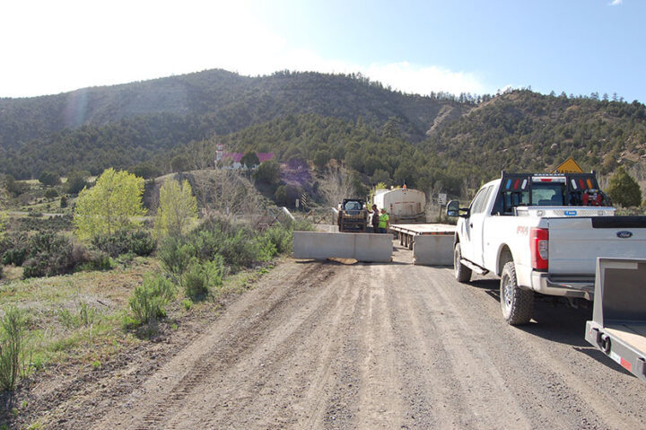
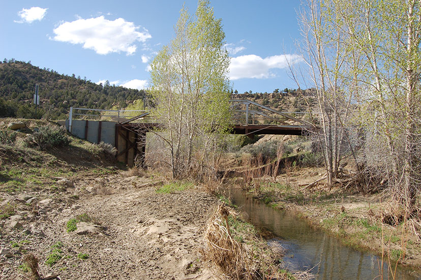
PHOTO: The failing Pagosa Junction Bridge over Cat Creek, May 5, 2023.
I’m sitting at the table with Laura Vanoni, who recently resigned from her position as director of the Archuleta County Transportation Department — the department that operates the Mountain Express Transit bus system here in Pagosa Springs. She’s now employed by the County to assist with grant writing and grant management… in particular, in connection with the proposed bus facility planned in Harman Park, adjacent to the Sheriff’s offices and County Courthouse.
She’s also familiar with the problems on County Road 500, aka Trujillo Road, and agreed to an interview.
It’s May 5, the day Archuleta County is scheduled to close the Pagosa Junction Bridge. (The closure happened later that day.)
Ms. Vanoni:
“When I first started with the County in October, 2020, I just did nothing but transit… but I started getting involved [in the CR 500 issues] because I knew there was a problem, and I knew it was on Southern Ute land. And I had worked previously with tribes in New Mexico and Texas; I’ve worked with Indian Affairs; I worked for the Pueblo of Sandia [in Albuquerque] as a planner. So I knew enough about federal highways, roads, tribal land and offered to assist the interim Public Works director, who started forwarding me all the information of what had gone on, before, and I contacted [the staff at the Southern Ute Indian Tribe].
“CDOT had given the County some grant money for the Pagosa Junction Bridge. $266,000, with $53,200 from the County. This was before I got here…”
Bob Perry, who was the County’s previous Public Works Director and who had written that grant, contacted Davis Engineering to produce a rough sketch of the bridge. When Ms. Vanoni was provided the drawing, she asked Davis Engineering about the next steps, and was told that the engineering couldn’t be completed, because Archuleta County didn’t have a ‘right-of-way’ for CR 500. Additionally, the required environmental studies had not been done, for the same reason.
At this point in time, the County had also become seriously concerned about a different section of CR 500 that was being eroded by the San Juan River.
“So I started doing some research, and basically, there was no right-of-way for the entire road. There was one MOU from 1974, between the County, the BOR [Bureau of Reclamation], the BIA, and the Tribe. The BIA was supposed to do a survey of one stretch of County Road 500… I looked for documentation that the survey had been done, and there was nothing. I contacted BIA; they didn’t have anything. I contacted the engineer in Alburquerque who was regional director and who would have that information; he didn’t have anything… so I called a friend at the Pueblo of Sandia to get some leads. In the meantime, I was talking with BOR about the road damage from the river…”
The federal Bureau of Reclamation gets involved in projects affecting the San Juan River, because they are responsible for the lands south of a stretch of CR500, along with the reservoirs within the Colorado River Basin, including the Navajo Reservoir in the southwest corner of Archuleta County, fed by the San Juan River…
“I knew that all tribes get federal highway funding for roads, which are inventoried by RIFDS…”
Here are a few highway-related acronyms, to help confuse us.
BIA/DOT: The Bureau of Indian Affairs Division of Transportation
IRR: Indian Reservation Roads programs
IRRBP: Indian Reservation Roads Bridge programs
FHWA: Federal Highway Administration
ITIMS: Integrated Transportation Information and Management System
RIFDS: Road Inventory Field Data System
The BIA IRR program is responsible for over 100,000 miles of roads, and more than 900 bridges, and uses specific software tools to provide oversight and management of the IRR program, including RIFDS.
“When I looked in the RIFDS records, it said that there is a 40-foot right-of-way on either side [of CR 500]. So, 80 feet. In talking with the Tribe, they claim there is no right-of-way they have on record…
“So we’re in a dilemma. The Tribe says there is no right-of-way. The RIFDS says there is. But there’s nothing on paper that shows a right-of-way. We wanted to get grant money for the sluff area, and we can’t, because there’s no right-of-way, and we can’t get engineering done.”
Ms. Vanoni’s main concern, initially, was the eroding roadway close to Mile Marker 34, but then the letter arrived from CDOT last November, requiring Archuleta County to repair or replace the failing Pagosa Junction Bridge. The County still has the previous grant for $266,000 for the bridge, but the cost for a new bridge has likely doubled since then. Maybe, more than doubled?
“The issue for the bridge is, you can’t just remove a bridge and plop another one down. Even if you had the right-of-way and you’re working inside that right-of-way, you’re involved with a tributary [Cat Creek] to the San Juan River, which is a tributary to the Waters of the United States. So the U.S. Army Corps of Engineers is not going to let you excavate and just start drilling. Even removing material is a problem…”
The project will require an environmental study, which Ms. Vanoni suggests, by itself, might use up a large pprtion of the $266,000 grant. But of course, no study has been done, because no right-of-way exists, and the County still doesn’t have the Tribe’s permission to enter into agreements regarding the right-of way issues.
At the moment, the bridge is closed.

“So even if we were to get a right-of-way, it’s going to take a ‘little bit of time’, to deal with the environmental issues, and the cultural issues. Because we will be disturbing land that both belongs to the Tribe, and is in the waterway of the U.S. So it’s a problem…”
I understood her to mean, by ‘a little bit of time’, actually ‘a great deal of time’.
As noted, the lack of a right-of-way is preventing work on two key CR 500 problems.
The Pagosa Junction Bridge.
And the erosion of the road at Mile Marker 34…

