The Pagosa Springs East End Multimodal Plan creates a stronger connection between the East End and other areas of town, while providing a better-functioning multimodal environment that supports access to businesses and recreational opportunities for residents and visitors alike…
— from Chapter 3 of the East End Multimodal Transportation Plan, 2022.
It’s a complicated challenge. Here we have roughly 44 acres of mainly commercial property… mildly dysfunctional in terms of transportation options, and devoid of residential housing. Can the Town of Pagosa Springs, in cooperation with the Colorado Department of Transportation (CDOT), make this district more attractive to pedestrians, cyclists and bus transportation?
The 179-page ‘East End Multimodal Transportation Plan’ suggests that they can.
We understand that urban planners are playing a ‘long game’ when they start re-designing a neighborhood to accommodate a wider range of transportation options. A long, and sometimes expensive, game.
I mentioned, yesterday in Part Two, the 30-year effort to build the River Walk along the San Juan River. Back in 1993, when my family and I departed from Alaska and moved into a small house on San Juan Street, the River Walk extended from Town Park to South Sixth Street, less than half a mile. That pedestrian-friendly pathway now extends almost two miles, from Yamaguchi Park to the intersection of First Street and Highway 160.
The River Walk is a lovely recreational pathway, well-traveled by tourists and people walking their dogs. Unfortunately, it has almost no connection to any commercial businesses. Yes, a pedestrian (and his or her dog) will stroll past the Root House coffee shop, and past the bridge leading to the Springs Resort. But that’s about the extent of it, in terms of commercial connections.
If, by some miracle, the River Walk were extended to the east — say, across a new pedestrian bridge — into the East End commercial district, then we might be getting somewhere.
The Town of Pagosa Springs is attempting to make that miracle happen, and the $180,000 ‘East End Multi-Modal Transportation Plan’ is part of their long-range effort. The Town is already working on a safer pedestrian crosswalk at the First Street-Highway 160 intersection, and also looking at grants to fund a safe pedestrian bridge leading from First Street, across the river to the East End commercial area.
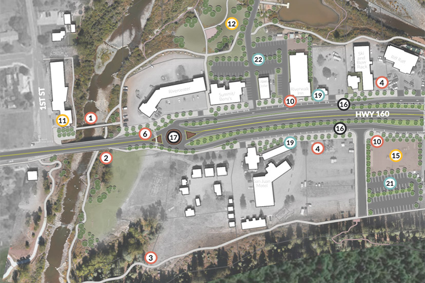
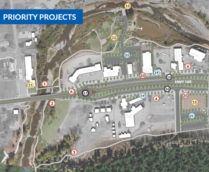
Back in Part One, we shared the following map. Dot Number 1 indicates a proposed pedestrian bridge leading from First Street to the River Center parking lot, which would facilitate pedestrians and cyclists to access the district without crossing the “perceived to be dangerous” First Street vehicle bridge.
We can also see a network of pedestrian/cycling pathways surrounding the commercial district. These pathways do not currently exist, other than in short segments here and there. As far as I know, the Town does not currently have the easement for these pathways, but property owners are sometimes willing to grant such easement. Or sell them.
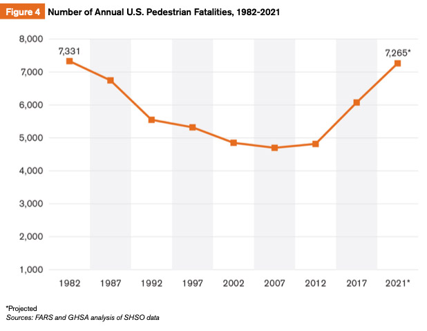
We also mentioned, previously, the fact that motor vehicles making left turns are among the most dangerous hazards in modern life. The hazards apply especially, perhaps, to cyclists and pedestrians. During the recent decade, U.S. pedestrian fatalities increased from 4,302 in 2010 to an estimated 6,607 in 2020, representing approximately 17% of all traffic deaths. Preliminary data suggest more than 7,200 pedestrian deaths in 2021.
According to the National Safety Council, 1,260 bicyclists were killed by vehicles in 2020, up 16% from the year before and an increase of 44% over the past decade. Preliminary figures recently released by the National Highway Traffic Safety Administration indicate cycling fatalities rose another 5% in 2021.
Something I didn’t know before researching this topic: the demographic group most prone to getting killed by a vehicle are not young children playing in traffic, but rather, seniors age 65 and older. Especially endangered are seniors over the age of 75.
You can probably come up with your own likely explanations for that statistic.
As we come to believe that walking and cycling are healthful activities, cars are killing us in greater numbers, thanks largely to the fact that streets and highways were originally designed to accommodate low-speed travel — horse-drawn wagons and bicycles — but were later usurped by motorized vehicles.
Looking at the map again, the feature indicated by Dot Number 17 is a roundabout.
At that location, we currently find a simple ‘driveway’ ingress/egress into the River Center parking lot and the north frontage road. The existing ingress-egress for the south frontage road is located another 50 yards to the east. The Plan’s roundabout would accommodate access to both frontage roads from one roundabout.
We also see a pedestrian crosswalk at Dot Number 6, as part of the roundabout design. We might hope this crosswalk is never used by people 75 and older.
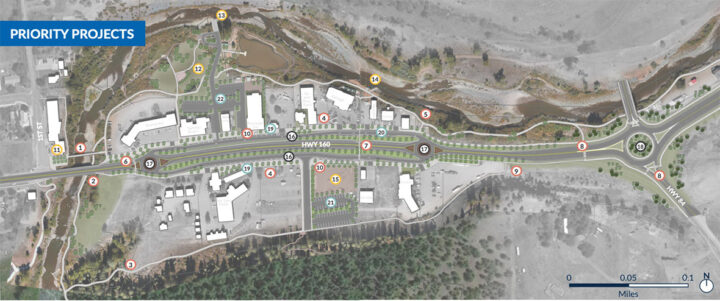
The full half-mile re-design for the East End includes three roundabouts; one at each end of the East End commercial district, and one at the nearby intersection of Highways 160 and 84. (You can click the map for a larger version.)
From the ‘Plan’, page 52:
Roundabouts help with vehicular circulation and eliminate the left turns that are difficult/dangerous to make and that cause backups on the frontage roads… They lead to a 30-50% increase in traffic capacity at each intersection, allowing traffic to flow more freely, and boast 90% fewer fatalities and 75% fewer injuries than other intersection types.
Assuming this general information is true (and why not make that assumption?) we still ought to be a bit more specific. How do roundabouts — of the size shown in the Plan — function on a rural highway plied by a steady stream of semi-trucks and 30-foot RVs, and in a climate where show plowing is a common requirement?
Here’s a comment from a citizen participant:
From a local friend with 15 yrs. experience with our Roads Dept. and now clearing snow at Wolf Creek Pass:
‘A roundabout is a bad idea with the large number of tractor-trailers and large RVs passing through. They create congestion & accidents as many drivers are unable to negotiate tight turns. Curbs on the outer-ring are damaged. Snow plows have difficulty plowing this configuration. The best solution to slow traffic here is a BIG traffic light. Use big warning signs before to alert drivers…’
I found these statements interesting, so I drove down to the East End to take a first-hand look at the intersections in question…
…because I suspect the construction of roundabouts would cost a pretty penny.


