At the conclusion of our lunch at a local Chinese restaurant, my friend and I were provided with the traditional bill accompanied by two Fortune Cookies.
I don’t normally give much weight to Fortune Cookie messages, but now and then, they seem to be speaking directly to me. This particular fortune reminded me, “Truth can be harsh, but it can be helpful.”
The Pagosa Daily Post may sometimes come across as ‘harsh’… but our intention is to be helpful.
We’re discussing the ‘East End Multimodal Transportation Plan’, the result of a year-long, $180,000 effort funded by the Town of Pagosa Springs and the Colorado Department of Transportation (CDOT). The process included three in-person public meetings and one ‘virtual’ public meeting, to get input from the general public and, in particular, from East End business owners.
Not everyone will have time to read through the 179-page ‘East End Multimodal Transportation Plan’, now adopted by the Pagosa Springs Town Council. Nor will everyone have an interest in reading the plan… nor in spending time thinking deeply about the issues posed.
In fact, I would be surprised if more than a dozen Pagosa Springs citizens eventually read the entire document. But that doesn’t make it an unimportant plan. In all likelihood, it will lead, eventually, to the expenditure of millions of taxpayer dollars.
To make life better, hopefully, for all of us.
As mentioned in Part One, the East End commercial district was developed in the 1960s and 1970s, more than half a century after the commercial and residential core of downtown Pagosa Springs. Unlike the rest of downtown, it built out after transportation by horse and bicycle had been abandoned in favor of automobile transportation. Our assumption, during most of the second half of the 20th century, was that gasoline would be forever affordable, and buying a new car or truck every few years was a sign of success.
Another difference in the development of the East End concerns the frontage roads. During the 1960s and 1970s, the Colorado Department of Transportation (CDOT) had come to the gradual realization that an automobile-centric lifestyle was causing more and more transportation fatalities and injuries, and that part of the problem was street and highway design leftover from the days of horse and buggy, when people traveled at 5 MPH instead of 45 MPH.
So when the East End commercial district began to build out, CDOT rolled out a different highway design.
Frontage roads.
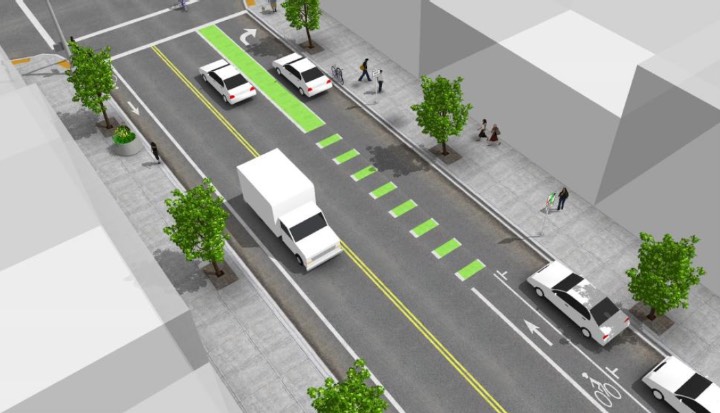
Here’s a CDOT drawing of a typical downtown street design that includes dedicated bike lanes, and nice wide sidewalks for pedestrians. This urban design echoes the days of horse and buggy travel, with modern enhancements to try and keep cyclists from getting killed.
This looks somewhat like the striping pattern CDOT has adopted for Highway 160, going through our historical downtown.
I live downtown, and occasionally ride my bike downtown. But I avoid the bike lanes on Highway 160, because downtown Pagosa has side streets and alleys that seem so much safer than a highway bike lane. In fact, over the past 10 years that we’ve had bike lanes striped into Highway 160, I think I’ve observed at most three, maybe four, people riding their bikes in those lanes.
We may ride bicycles, but we’re not crazy.
The basic transportation pattern, downtown, is based on the idea that people will park their car next to the sidewalk, and then walk to the restaurant or retail store or other business. It’s actually a pretty good arrangement, in terms of pedestrian safety.
But the Town of Pagosa Springs was not satisfied with that pattern, and began requiring businesses to provide private, on-site parking lots.
On-site parking lots provide a real measure of convenience, because I can park my car directly in front of the business, and won’t have to walk two blocks, or cross a dangerous highway.
But then we have the problem of people driving into, and out of, private parking lots… and making left turns.
Left turns, when other vehicles are traveling at 45 MPH, get people killed and injured. And that includes pedestrians and cyclists, getting killed. And when every business on the street needs a driveway into and out of their private parking lot, you’re talking a lot of potential accidents.
When the East End commercial district was getting platted, CDOT had the bright idea of including frontage roads. In this particular instance, CDOT designed a frontage road on both sides of the main highway thoroughfare, with a limited number of access points.
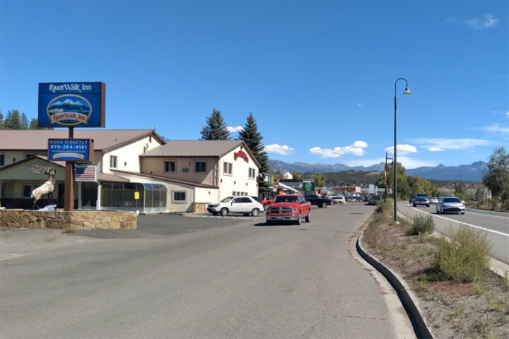
In this photo, from the ‘East End Multi-Modal Transportation Plan’, we can see the frontage road on the left and the main highway on the right.
This street design keeps dangerous left turns to a minimum, and slows the traffic in front of the commercial buildings.
But what CDOT forgot were the nice wide sidewalks, and any kind of pedestrian- or bicycle-access from the rest of downtown. I suppose they thought, well, Americans had stopped walking, and had stopped riding bicycles. We didn’t need sidewalks in 1965. We drove cars, and we parked right in front of each business.
Fast forward to 2022. We’ve realized that walking and bicycling are healthful activities, and driving cars is not. We’ve been warned that excessive automobile use may be ruining the global climate. The price of gasoline has increased (especially in Pagosa Springs.)
Over the past 30 years, the Town of Pagosa Springs has invested millions of dollars into making the historical downtown more pedestrian- and bicycle-friendly. A pleasant and scenic walking trail extends from the town’s southern boundary at Yamaguchi Park… following the San Juan River, past three pedestrian bridges and four public parks, to stop at First Street.
20 years ago, the Town built a nice, wide sidewalk the length of Hot Springs Boulevard, even though most of the parcels on either side of the boulevard have remained stubbornly vacant.
Lots of money has been put into making our five downtown parks more enjoyable.
Very little has been done by the Town government, over the past 30 years, to improve the consumer’s experience in the East End…


