I never studied Samuel Taylor Coleridge’s poem The Rime of the Ancient Mariner in English class, so I wasn’t familiar with the origin of a particular metaphor.
Having an albatross hanging around one’s neck.
In Coleridge’s poem, a sailor kills a harmless albatross — a bird considered lucky in maritime folklore — and the act triggers misfortune for the whole crew.
As penance, the sailor is forced to wear the animal’s carcass around his neck.
Ah! well a-day! What evil looks
Had I from old and young!
Instead of the cross, the Albatross
About my neck was hung…
The derivative metaphor is still in use today, to characterize an unpleasant circumstance that’s seemingly impossible to avoid.
While we watch the Pagosa Springs economy stumble into 2023, with a housing crisis albatross hung around its neck, our municipal government has other priorities to consider.
Other albatrosses, perhaps?
Take the ‘East End’, for example. The East End is a somewhat functional commercial area east of the San Juan River bridge, developed long after the Town of Pagosa Springs was first platted back in 1883.

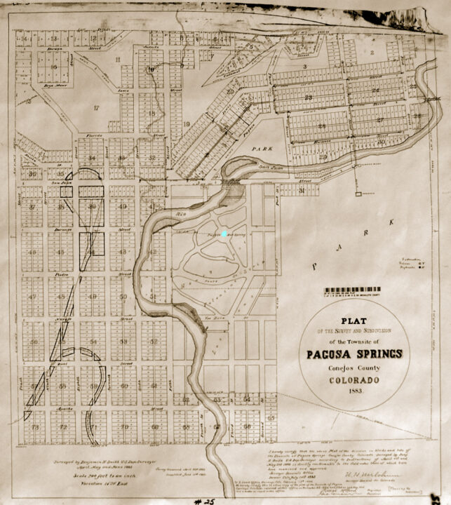
As imagined by the surveyors who drew the first ‘Town of Pagosa Springs’ map, above, the one-square-mile community was centered around the Pagosa Hot Spring pool, with a sizable park occupying the southeast corner (the park now known as Reservoir Hill) and with residential homes and businesses surrounding the hot spring on three sides. The eastern limit of downtown, at First Street, was tucked into an elbow of the San Juan River.
The area east of the San Juan River? Ranches? Sawmills? Dairy farms? Wilderness? The surveyors imagined a bridge heading east, but whatever that bridge would lead to, wouldn’t be part of the town itself.
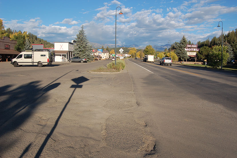
Sometime around 1964 (as far as I can tell) a new commercial area began to grow up on the other side of the First Street Bridge. Unlike the historical downtown neighborhoods, this development was purely commercial; no residential homes were included. As such, the development was also conceived as automobile-centric. The developers assumed that anyone patronizing the shops and restaurants would arrive by car or pickup truck.
In line with those assumptions, no sidewalks were installed. No crosswalks were included. Any pedestrian access from downtown — if such a thing was even imagined — was via a narrow sidewalk over a narrow vehicular bridge.
Nor was such automobile-centric development unusual in the 1960s and 1970s. Nearly every development in Archuleta County after 1960 assumed that people would transport themselves in private vehicles, and would park directly in front of, or at least near, any business or government office they were visiting.
The entire 21-square mile Pagosa Lakes development, to the west of downtown, was designed without sidewalks. Ditto Aspen Springs. Ditto Loma Linda. Ditto San Juan River Village. Ditto Alpha Subdivision. Ditto Vista mobile home park.
Sidewalks? How old-fashioned.
Crosswalks? Who would ever use them?
Even in the historical downtown, sidewalks were installed only in commercial areas.
Times have changed, and government funding for transportation has changed, too.
Much of the ‘transportation’ funding available from state and federal agencies is now tied to the concept of ‘multi-modal transportation’. Rather than pouring money exclusively into more travel lanes for vehicles, a project seeking funding from the Colorado Department of Transportation (CDOT) or from the Federal Highway Administration (FHWA) is typically expected to include pedestrian, bicycle, and/or public transit amenities.
Over the past 30 years, the Town of Pagosa Springs staff has been honing their grant-writing skills in an attempt, whenever possible, to make local improvements without using local taxes. This has occasionally led the Town administration to apply their focus to far-fetched projects such as, for instance, the long-suffering and improbable ‘Town to Lakes Trail’ project.
Rather than focusing mainly on the most serious high-priority needs of the community, our local governments sometimes follow, instead, the path that leads to the most convenient grant funding.
Recently, the Town of Pagosa Springs was blessed with a $157,000 CDOT grant to study transportation improvements at the East End. It appears the Town also spent an additional $40,000 in local tax revenues on the study.
I am not yet able to locate the ‘Pagosa Springs Multimodal Transportation Plan’ on the Town website, but I imagine it will appear there soon enough. Anyone who eager to review the plan can download it from the Daily Post Dropbox using this link… but the file is very large and may take 15 minutes or longer to download.
The Town is planning to spend $600,000 more on the project, over the next few years. Whether that will be grant funding, or local tax revenues, or private investment, is not yet clear. However, I was unable to locate, anywhere in the 179-page plan, an estimate of what any of the proposed ‘priority projects’ would cost.
I mention private investment specifically, because the ‘Pagosa Springs East End Multi-Modal Transportation Plan’ doesn’t mention private business funding, to help cover the millions of dollars such an extensive re-development plan would likely cost… even though nearly all of the properties that would benefit from the plan appear to be private commercial businesses.
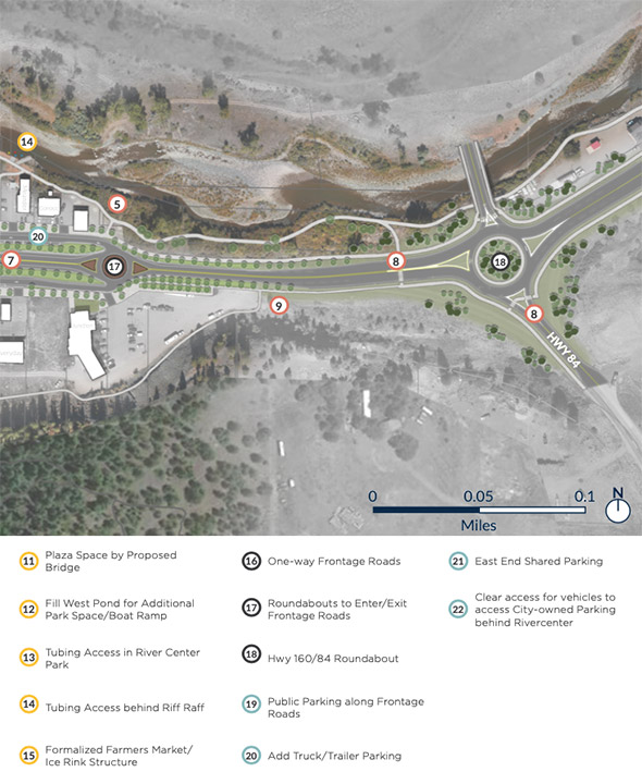
Here are two of the maps that came out of that study. Note that some of the numbered items shown on the first map are named in the second map text, and vice versa.
 The plan mentions these ‘Overarching Comments”:
EXCITEMENT FOR THE PROPOSED PROJECTS
- Like the wide sidewalk and organized frontage roads
- Looking forward to an ice rink/farmers market shelter
- Prefer angled parking since it allows for more spaces, and people are more familiar with how to park
- Excited to be able to bike to this area much more easily with these improvements in place
- More river access will be beneficial
CONCERNS ABOUT THE PROPOSED PROJECTS
- Like the wide sidewalk and organized frontage roads
- Would rather see money spent on acquiring space for parking than filling in the pond
- Roundabouts are not preferred by many
ADDITIONAL THOUGHTS TO CONSIDER
- Look into drought-resistant plantings in areas where plants are shown as proposed
- Ensure there is adequate trailer and RV access
- Dedicated bike facilities would be safer
- Prioritize less traffic coming into downtown
- Consider including boat/tube access at the Hwy 160/84 roundabout
One additional thought to consider. Are we looking at an expensive albatross?


