And why am I interested in monitoring this particular lake? In years past I have been able to paddle my kayak from Pearce Ferry, on the east end of Lake Mead, into the very pretty western Grand Canyon, but in the past few years (writing in 2005), the east end of the lake has dried up, making an enjoyable outing impossible until the water rises again — assuming it ever does…
— from Paul Lutus’ ‘Arachnoid.com’ blog, tracking the decline of Lake Mead.
We posted an opinion piece yesterday morning by activist Gary Wockner, one of the Coloradans most skeptical of the Colorado Water Plan and the ongoing efforts by numerous agencies to divert ever more water out of our streams and rivers.
His op-ed refers to the Federal Energy Regulation Commission (FERC) permit approval for a new water diversion out of Lake Powell:
FERC identified in its order numerous and fatal flaws of this project including lack of access to tribal and federal lands, no consent from the Navajo Nation, failure to initiate government-to-government consultation with the tribe, infeasibility of the project due to climate change, and the effects of the project on water rights and water resources, threatened and endangered species, and water quality, among others. Despite these red flags, FERC cursorily dismissed each of the concerns as premature and inconsequential, and granted the permit.
Mr. Wockner also quotes Samantha Ruscavage-Barz, Legal Director at WildEarth Guardians:
“Basic climate science reveals that Lake Powell is not a reliable water source for this ill-conceived project.”
The reference to ‘basic climate science’ refers to recent computer models that show a drier climate throughout the American Southwest over the next few decades, allegedly due to the continued use of fossil fuels all around the globe. But even without access to clever computer models, we have all seen Lake Powell and Lake Mead — America’s two largest water reservoirs — struggle to remain even half full, as we watch water users extract more water than nature can replace.
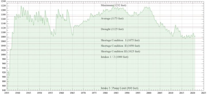
At the beginning of today’s installment, I shared a brief quote from Paul Lutus’ ‘Arachnoid.com’ website, where he discusses the falling water level in America’s largest water reservoir, Lake Mead. Mr. Lutus also maintains, on his website, a regularly-updated graph of the water levels in Lake Mead, apparently because he is a recreationalist.
As we can see from this chart, Lake Mead — created by the new Hoover Dam in 1935 — was nearly full in the summer of 1941, but its ability to remain full has been challenged by climatic variations. Following 2001, the reservoir levels took on a steady decline, and recently have been barely above “Shortage Condition I”.
The federally-funded reservoir had two main purposes. First, it was designed to smooth out the damaging and unpredictable “flooding, drought, flooding, drought” cycle of the Colorado River as it flowed past Arizona and Utah, and then along the border between California and Arizona toward the Gulf of Mexico. Second, the Hoover dam generates hydroelectric power.
It has done those two things. It has also done things that were, perhaps, not foreseen — such as fostering the explosive growth of Las Vegas, Nevada.
Our federal engineers and politicians, in 1935, did not value the natural flow of rivers in the American West, and believed we would all be happier with a well-tamed river. And the Colorado River was not the only one “harnessed” during the first half of the 20th century.
From the Bureau of Reclamation website:
Between 1988 and 1994, Reclamation underwent major reorganization as construction on projects authorized in the 1960s and earlier drew to an end. Reclamation wrote that “The arid West essentially has been reclaimed. The major rivers have been harnessed and facilities are in place or are being completed to meet the most pressing current water demands and those of the immediate future.”
I’m not sure when, exactly, the Bureau opined that “The arid West has been reclaimed.” If you read the rest of the brief history shared on the Reclamation website — and if you read between the lines — you get a sense that its current federal employees suspect that at least some of the activities between 1902 and 1994 were, in hindsight, damaging to the longterm health of the American West… especially, perhaps, its environmental health. Were the dams worth the price… now that some of them are nearing the end of their useful lives?
Has the American West created an artificial (and ultimately fragile) economy built upon unsustainable water infrastructure?
Some discussions at recent San Juan Water Conservancy District board meetings have focused on the environmental health of the San Juan River, especially following the release of the “West Fork Water Rights” draft report created by Lakewood-based Wilson Water Group.
Note: I currently serve as a volunteer member of the SJWCD board. This editorial series expresses my own research and opinions, and does not necessarily reflect the opinions of any other SJWCD Board members, nor the decisions and policies of the SJWCD Board as a whole.
We’re now a half century past the Bureau of Reclamation’s heyday during the 1960s, when we were making the American West great again by harnessing and taming its rivers. We’re half a century past the time when the Southwestern Water Conservation District filed for the right to build a 32,000 acre-foot reservoir at the base of Wolf Creek Pass, with a plan to someday stymie the flow of the West Fork of the San Juan River.
Time to let go of that dream?
Time to abandon those water rights and allow the San Juan River to flow naturally and unhindered?
I wonder what our local taxpayers think about these questions.


