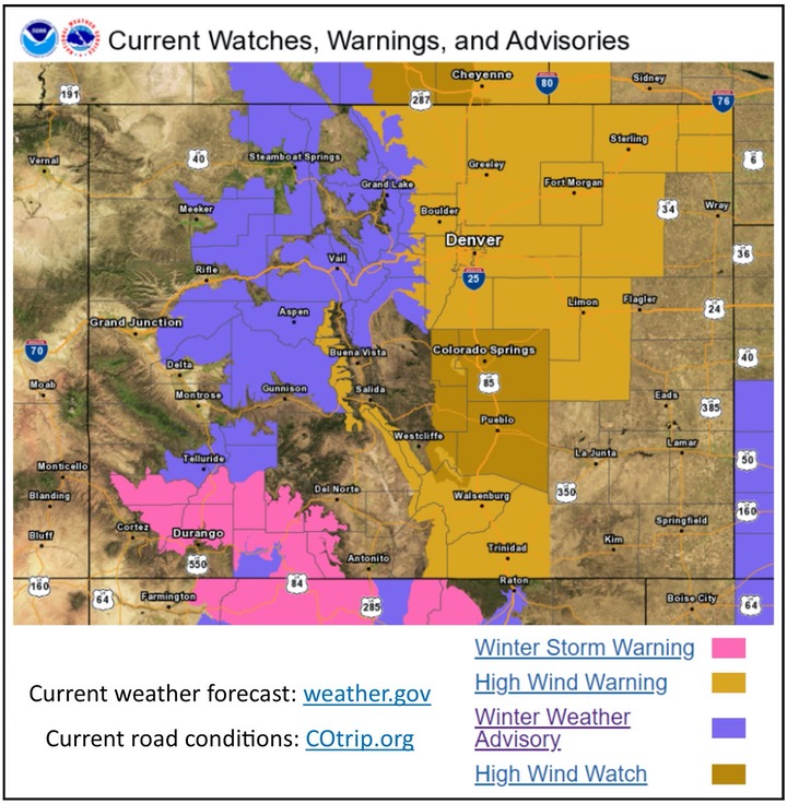
The Colorado Department of Transportation urges motorists to plan for severe weather and heavy traffic during the Martin Luther King Jr. Holiday weekend. CDOT asks holiday travelers to always check road and weather conditions for the route you plan to take before beginning your trip. Road conditions are always available at cotrip.org (mobile-friendly). Please take note of a new brochure available online for tourists visiting Colorado.

High wind watches and warnings are in effect for most of the front range, including Denver and the I-25 corridor, from 1pm Friday to 2pm Saturday. High profile vehicles should be prepared for the potential of high wind advisories and high wind restrictions on roadways throughout the state. Visibility will also be a concern with high winds and snowfall, which could cause ground blizzards.
SOUTHWEST COLORADO
A Winter Storm Warning is currently in effect for The San Juan Mountains until Friday night. More consistent, longer-lasting and heavier snowfall accumulations are expected compared to other parts of Colorado. Southwest Colorado high country areas will also experience high winds, resulting in blowing snow and reduced visibility on roadways. CDOT asks travelers to be aware of potential road closures if the storm causes unsafe driving conditions, particularly along CO 145 Lizard Head Pass, US 550 mountain pass corridor and US 160 Wolf Creek Pass.
I-70 MOUNTAIN CORRIDOR & NORTHWEST COLORADO
CDOT anticipates extreme conditions on I-70 for the peak traffic period on Friday, as motorists head into the mountains for the holiday weekend. CDOT asks motorists to delay travel on the I-70 Mountain Corridor until Saturday, unless drivers are equipped with proper tires for winter travel in the mountains. The National Weather Service is forecasting a fast, heavy snowstorm on Friday, January 17. Snow showers are expected to develop by sunrise Friday, with a heavy burst of snow and wind is expected along the corridor between 10am – 1pm. Snow totals may not seem significant (3” – 7”) but heavy snowfall rates in a short period of time will likely affect a high number of drivers on the road. The storm is anticipated to affect Rabbit Ears Pass as well. Snow will likely decrease during Friday afternoon with little additional accumulation expected after about 8pm. Drier weather is expected for the rest of the weekend.
I-25 CORRIDOR
CDOT anticipates high winds will also dramatically affect weekend holiday traffic on Friday along the I-25 corridor. The National Weather Service has issued a High Wind Watch Friday morning through Friday evening for the foothills and northern plains up to the Wyoming border. Westerly winds are expected to be between 25-35mph and possible gusts up to 70 mph. Closures north of Fort Collins along I-25 may occur depending on the wind event. Previous high winds have affected tractor trailers as well as small vehicles. Light snow showers are also expected on Friday along the Front Range foothills.
WHOLE SYSTEM. WHOLE SAFETY
In early 2019, CDOT announced its Whole System. Whole Safety initiative to heighten safety awareness. This initiative takes a systematic, statewide approach to safety combining the benefits of CDOT’s programs that address driving behaviors, our built environment and the organization’s operations. The goal is to improve the safety of Colorado’s transportation network by reducing the rate and severity of crashes and improving the safety of all transportation modes. The program has one simple mission – to get everyone home safely.
CDOT has approximately 3,000 employees located throughout Colorado, and manages more than 23,000 lane miles of highway and 3,429 bridges. CDOT also manages grant partnerships with a range of other agencies, including metropolitan planning organizations, local governments and airports. It also administers Bustang, the state-owned and operated inter-regional express service. Gov. Jared Polis has charged CDOT to further build on the state’s multimodal mobility options.
