We rarely get a chance to hear local businessman Bill Dawson speak in a public meeting; he’s somewhat more reclusive than his long-time business partner Matt Mees. In fact, in my 12 years of reporting on politics and development issues in Pagosa Springs, I can’t recall ever hearing Mr. Dawson address a government board at a public meeting.
Of course, the September 17 executive session was not exactly a public meeting. That is to say, the Town Council and the Springs Partners assumed it was not a public meeting. But the audio recording – of the portion of that meeting that included the participation of Springs Partners Mees and Dawson — has now become a public record, so perhaps we could say that the Springs Partners’ testimony was “destined to be shared publicly.”
We are now listening to Bill Dawson, who started off by thanking the Council for the opportunity to speak with them. [Portions of the audio recording are inaudible.]
“We began in 2003 with a very, very basic plan for our project. In 2004, we went with [Dewindt?] & Associates in Santa Fe, a well respected architecture and land planning company. We finished up in 2005 when we sold [the Springs Resort] to the Whittingtons; we retained 31 acres [of vacant travertine meadow south of the Springs Resort.] In 2007 .. we sold the 31 acres to the Whittingtons. And when we did that, we released four acres for them to build the new [Ecoluxe Hotel]. We sold that property for $4.5 million.
“In 2012 … [inaudible] … we got the property back in a foreclosure, and then we had some legal issues … [inaudible] .. and so we have the property back. But we’re kind of in idle, until we know if the Town is going to build the bridge. The two [Sketch Plans] provide for totally different options. We’re looking at a total expenditure of from $150 million to $250 million, depending on which of the Plans take place.
“Plan A is with the bridge. Plan B, which was basically approved by Town Council, is without the bridge, and it provides for more of a resort type development… with the main access being Hot Springs Boulevard.”
We’ll pause here for some background. The Town of Pagosa Springs has a Comprehensive Plan that supposedly guides the future development of the incorporated municipality, by recommending refinements to the Town’s Land Use and Development Code, the LUDC. (You can download the ‘Comp Plan’ on the Town website here. You can download the LUDC from the same page.) The Town spent tens of thousands of dollars on consultants while developing the Comp Plan, and utilized hundreds of hours of volunteer input from local citizens.
One of the tools used to control future development is “zoning.” A municipal “zone” defines what types of buildings may be built within that zone. If you buy property within a certain “zone” you are basically granted an automatic right to build any of the types of buildings allowed in the zone, so long as you meet the code requirements for each building type. The vacant 27 acres owned by the Springs Partners is zoned “Mixed-Use Residential” which allows for a wide range of building types. In addition, the Springs Partners obtained from the Town Council, in 2012, specific “vested” rights preserving their right to build out a certain mix of building types during a ten-year period, from 2012 until 2022.
As we can recall, the future of the Pagosa Springs economy looked a bit shaky in 2012, and no one was building out any large subdivisions. So the Springs Partners asked for their land use rights to be preserved for 10 years — in fact, they requested the option for two possible and specific development plans consisting of lodging, commercial and residential. Here’s Sketch Plan A, as approved in 2012:
In a special effort to insure the vitality of the historic downtown, the Town Council augmented the Comp Plan during 2006 by spending many more thousands of dollars on consultants and many more hours working with volunteer citizens, to develop a ‘Downtown Master Plan.’
You can download the Downtown Master Plan from this web page.
The general idea with the Downtown Master Plan was to define some esthetic values and some multi-modal transportation patterns that would make downtown more ‘attractive’ and ‘pedestrian friendly.’ The plan was officially adopted by the Town Council in 2007. The three pedestrian bridges that now direct foot traffic towards the Springs Partners’ vacant 27-acre property are components of this pedestrian-friendly plan.
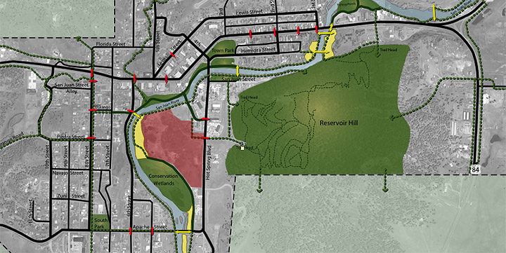
In other words, for many years, the Town has been striving to discourage automobile traffic within the downtown area, and to promote, instead, bicycle and foot traffic. According to the Downtown Master Plan, the pedestrian traffic we wanted to encourage would follow these routes… someday:
(I have highlighted in pink in the approximate location of the Springs Partners’ 27 acres.)
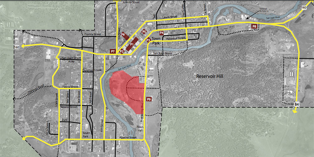
When we look at the Downtown Master Plan’s vehicle circulation traffic map for downtown Pagosa…
…we clearly see that there is no bridge at South 5th Street. (How many thousands of dollars did this map cost? I cannot say.) The vacant 27 acres (actually, 31 acres in 2007) is served in this plan by the Hot Springs Boulevard bridge and by a semi-circular roadway within the proposed development. For some reason, the Town Council believed — in 2007 — that a proposed $250 million, 31-acre development could be conveniently served by our existing system of pedestrian and vehicle bridges.
This plan seemed acceptable to everyone… until the Whittington family walked away from the purchase of the vacant 27 acres. That was probably a sensible move on their part, considering that downtown Pagosa is seeing almost no commercial development; several existing empty lots right on Highway 160 have been sitting vacant, and on the market, for ten years now. Who would want to pay the property taxes on 27 vacant acres, when the demand for new buildings in Pagosa is basically non-existent?
Springs Partner Bill Dawson:
“Sketch Plan B has more of a resort type look, and the main access off Hot Springs Boulevard. And the question you have to ask yourself is, can Hot Springs Boulevard support the density of the approved plan? Probably not!”
Then Mr. Dawson made an [inaudible] joke — something about Town Attorney Bob Cole and the 2012 vested rights agreement and a lawsuit — which elicited some laughter, including from Mr. Cole.
Mr. Dawson:
“So we have [commercial businesses] all up and down Putt Hill, and what we need is to develop [the vacant 27 acres] to create a revenue stream for the Town to put back into downtown redevelopment. And really, that never really happened. And I guess this is the last chance I see, for the Town to really take the bull by the horns, and by building the 5th Street bridge we really can create another expansion of the downtown, create a truly operational downtown — quite a bit larger. We would have a concentration of retail shops on both sides of the highway … [inaudible] … Matt and Mike Davis [of Davis Engineering] have put together a plan for the road access, and it kind of shocked me. I thought the [right-of-way for the bridge] would take up about 2 acres, but now it looks more like 3 acres.”
In the approved 2012 plan, the right-of-way for the proposed South 5th Street bridge occupies 1.13 acres. The rest of the internal road system takes up almost four acres.
The parking lots for vehicles, combined with the vehicle roadways, appear to take up maybe 50 percent of the development… or more? To put it simply, this is not a pedestrian-friendly development.


